
-
Federal
AMSR-E/AMSR2 Unified L3 Daily 12.5 km Brightness Temperatures, Sea Ice Concentration, Motion & Snow Depth Polar Grids V001
National Aeronautics and Space Administration —
This data set reports average daily horizontally and vertically polarized brightness temperatures; sea ice concentrations; and snow depths over sea ice on 12.5 km... -
Federal
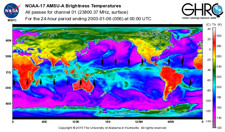
ADVANCED MICROWAVE SOUNDING UNIT-A (AMSU-A) SWATH FROM NOAA-17 V1
National Aeronautics and Space Administration —
AMSU-A, the Advanced Microwave Sounding Unit, is a 15-channel passive microwave radiometer used to profile atmospheric temperature and moisture from the earth's... -
Federal
Defense Meteorological Satellite Program (DMSP)
National Oceanic and Atmospheric Administration, Department of Commerce —
The Defense Meteorological Satellite Program (DMSP) satellites collect visible and infrared cloud imagery as well as monitoring the atmospheric, oceanographic,... -
Federal
SMAP L1A Radiometer Time-Ordered Parsed Telemetry V002
National Aeronautics and Space Administration —
Each Level-1A (L1A) granule incorporates all radiometer data downlinked from the Soil Moisture Active Passive (SMAP) spacecraft for one specific half orbit. The data... -
Federal
TROPICS05 L2B Tropical Cyclone Intensity Estimate (TCIE) Algorithm V1.0
National Aeronautics and Space Administration —
The "Time-Resolved Observations of Precipitation structure and storm Intensity with a Constellation of Smallsats" (TROPICS) mission has a goal of providing nearly... -
Federal
AMSR-E/AMSR2 Unified L3 Daily 6.25 km Polar Gridded 89 GHz Brightness Temperatures V001
National Aeronautics and Space Administration —
This data set reports 6.25 km resolution, horizontally and vertically polarized average daily 89.0 GHz brightness temperatures for the Advanced Microwave Scanning... -
Federal
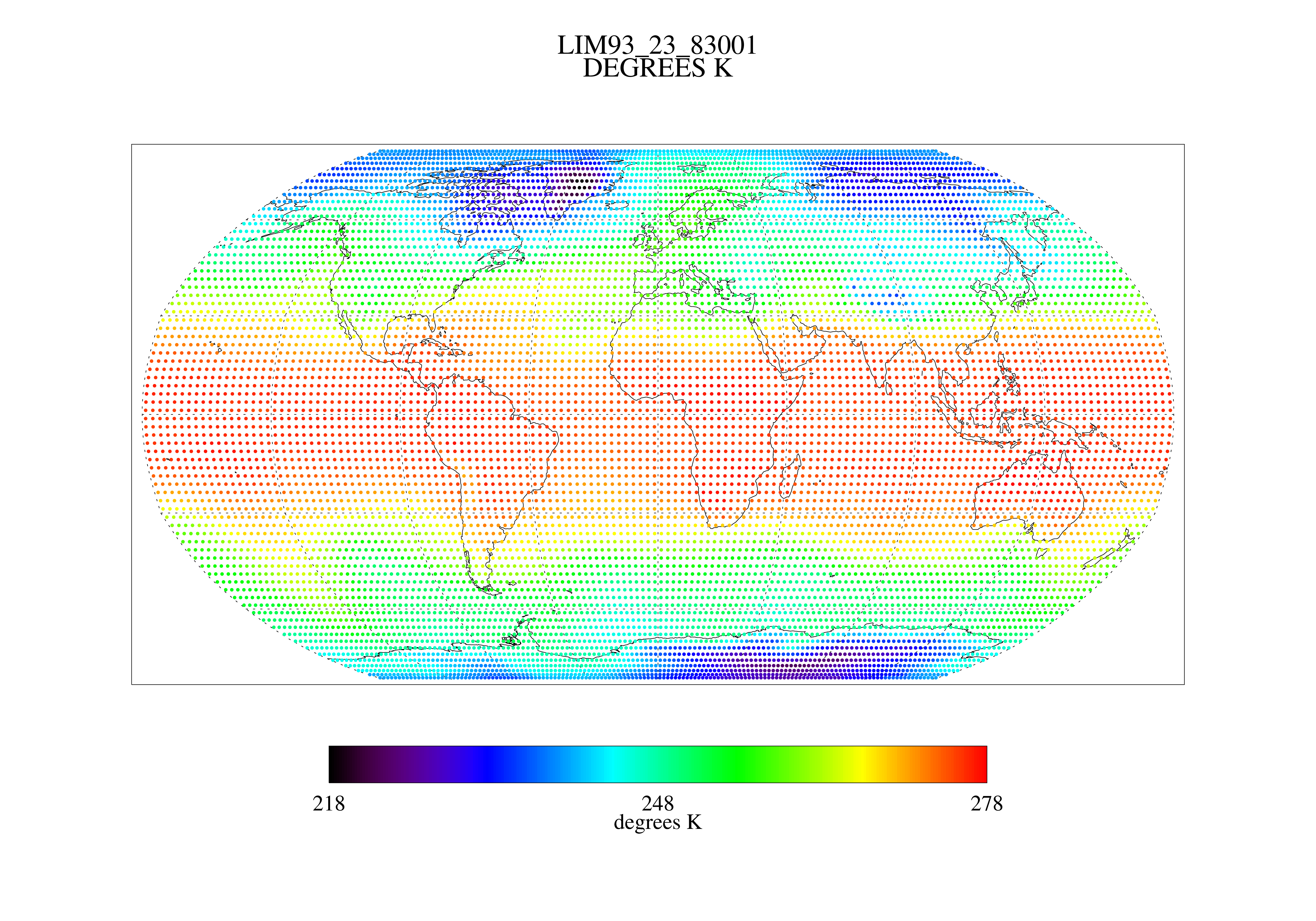
MSU Ch 2/3 Daily Lower Troposphere Temps with Limb93 Correction L3 1 day 2.5 degree x 2.5 degree V001 (MSULTT) at GES DISC
National Aeronautics and Space Administration —
The Microwave Sounding Unit (MSU) Lower Troposphere Deep Layer Temperature product (MSULTT) provides gridded lower tropospheric temperatures derived from MSU... -
Federal
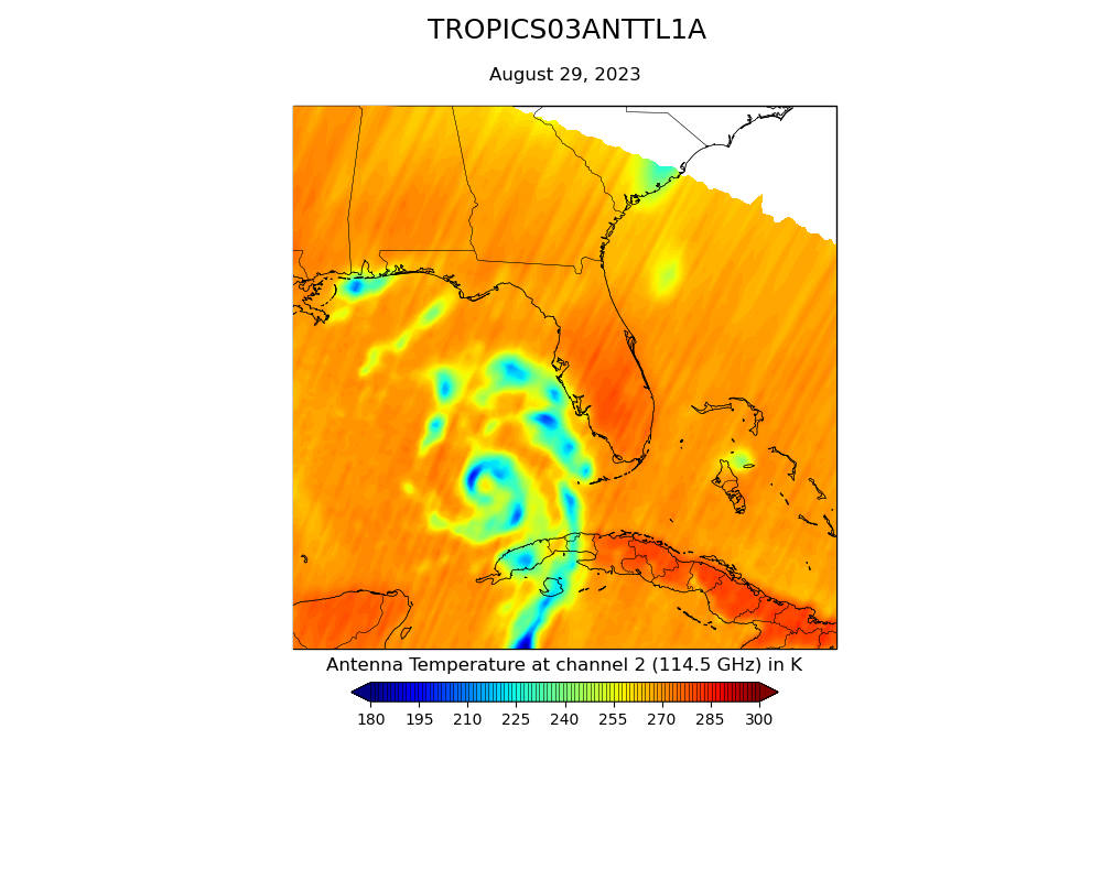
TROPICS03 L1A Orbital Geolocated Native-Resolution Antenna Temperatures V1.0
National Aeronautics and Space Administration —
The "Time-Resolved Observations of Precipitation structure and storm Intensity with a Constellation of Smallsats" (TROPICS) mission has a goal of providing nearly... -
Federal
SMAP L2 Radar/Radiometer Half-Orbit 9 km EASE-Grid Soil Moisture V003
National Aeronautics and Space Administration —
This Level-2 (L2) soil moisture product provides estimates of global land surface conditions retrieved by both the Soil Moisture Active Passive (SMAP) radar and... -
Federal
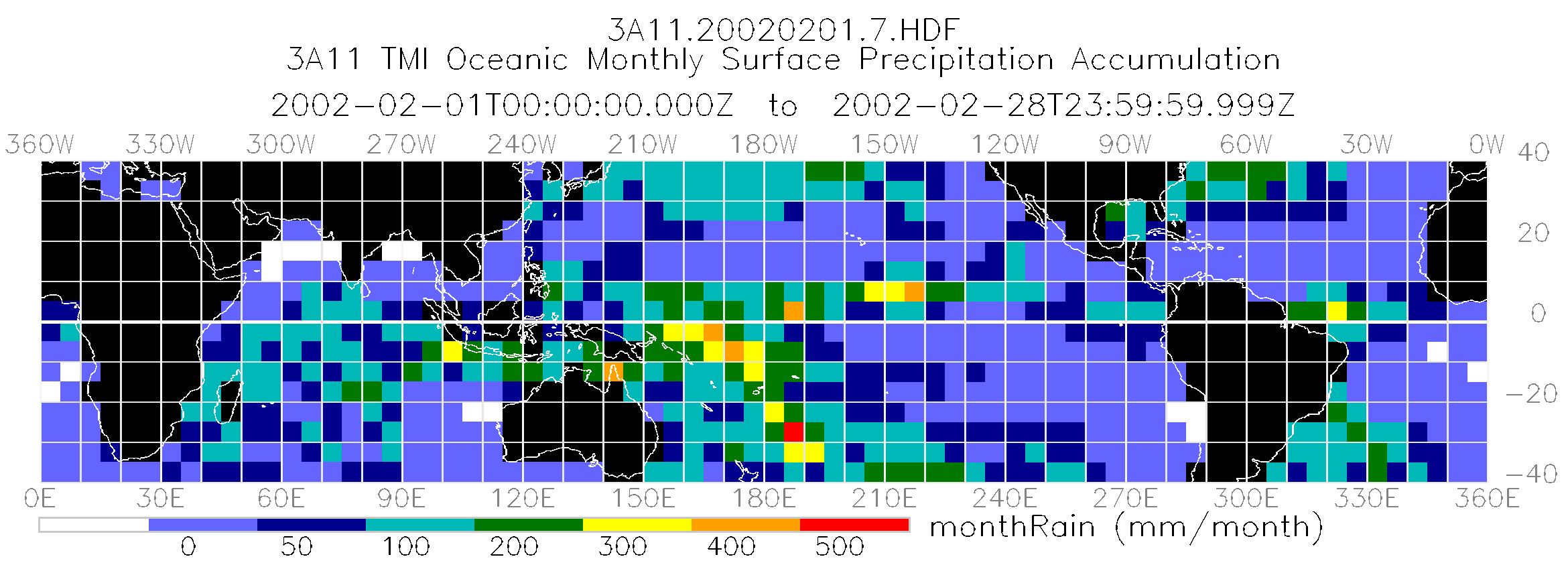
TRMM Microwave Imager Oceanic Rainfall L3 1 month 5 degree x 5 degree V7 (TRMM_3A11) at GES DISC
National Aeronautics and Space Administration —
The new equivalent for this dataset should be searched for as "GPM_3GPROFTRMMTMI_CLIM". The TMI Gridded Oceanic Rainfall Product, also known as TMI Emission, consists... -
Federal
AMSR-E/Aqua Daily L3 Surface Soil Moisture, Interpretive Parameters, & QC EASE-Grids V002
National Aeronautics and Space Administration —
This gridded Level-3 land surface product (AE_Land3) includes daily measurements of surface soil moisture and vegetation/roughness water content interpretive... -
Federal
SMAP L3 Radar/Radiometer Global Daily 9 km EASE-Grid Soil Moisture V003
National Aeronautics and Space Administration —
This Level-3 (L3) soil moisture product provides a daily composite of global land surface conditions retrieved by both the Soil Moisture Active Passive (SMAP) radar... -
Federal
GPM GROUND VALIDATION CONICAL SCANNING MILLIMETER-WAVE IMAGING RADIOMETER (COSMIR) GCPEX V1
National Aeronautics and Space Administration —
The GPM Ground Validation Conical Scanning Millimeter-wave Imaging Radiometer (COSMIR) GCPEx dataset used the Conical Scanning Millimeter-wave Imaging Radiometer... -
Federal
TROPICS06 L1A Orbital Geolocated Native-Resolution Antenna Temperatures V1.0
National Aeronautics and Space Administration —
The "Time-Resolved Observations of Precipitation structure and storm Intensity with a Constellation of Smallsats" (TROPICS) mission has a goal of providing nearly... -
Federal
TROPICS05 L1A Orbital Geolocated Native-Resolution Antenna Temperatures V0.2
National Aeronautics and Space Administration —
The "Time-Resolved Observations of Precipitation structure and storm Intensity with a Constellation of Smallsats" (TROPICS) mission has a goal of providing nearly... -
Federal
SMAPVEX16 Manitoba Radiometer Brightness Temperature Data V001
National Aeronautics and Space Administration —
This data set contains brightness temperatures obtained by in situ L-band radiometers. The data were collected for the Soil Moisture Active Passive Validation... -
Federal
SMAP L2 Radar/Radiometer Half-Orbit 9 km EASE-Grid Soil Moisture V003
National Aeronautics and Space Administration —
This Level-2 (L2) soil moisture product provides estimates of global land surface conditions retrieved by both the Soil Moisture Active Passive (SMAP) radar and... -
Federal
AMSR-E/Aqua Daily L3 6.25 km 89 GHz Brightness Temperature Polar Grids V003
National Aeronautics and Space Administration —
This Level-3 gridded product (AE_SI6) includes brightness temperatures at 89.0 GHz. Data are mapped to a polar stereographic grid at 6.25 km spatial resolution. This... -
Federal
SMAPVEX16 Manitoba Radiometer Brightness Temperature Data V001
National Aeronautics and Space Administration —
This data set contains brightness temperatures obtained by in situ L-band radiometers. The data were collected for the Soil Moisture Active Passive Validation...

Official websites use .gov
A
.gov website belongs to an official government
organization in the United States.
Secure .gov websites use HTTPS
A
lock (
) or https:// means you’ve safely connected to
the .gov website. Share sensitive information only on official,
secure websites.