
-
Federal
Tropical Cyclone PRecipitation, Infrared, Microwave, and Environmental Dataset (TC PRIMED)
National Oceanic and Atmospheric Administration, Department of Commerce —
The central components of this dataset are satellite passive microwave observations centered on tropical cyclones from imagers such as AMSR2, AMSR-E, AMSU-B, ATMS,... -
Federal
ADVANCED MICROWAVE SOUNDING UNIT-A (AMSU-A) SWATH FROM NOAA-15 V1
National Aeronautics and Space Administration —
AMSU-A, the Advanced Microwave Sounding Unit, is a 15-channel passive microwave radiometer used to profile atmospheric temperature and moisture from the earth's... -
Federal
Defense Meteorological Satellite Program (DMSP)
National Oceanic and Atmospheric Administration, Department of Commerce —
The Defense Meteorological Satellite Program (DMSP) satellites collect visible and infrared cloud imagery as well as monitoring the atmospheric, oceanographic,... -
Federal
SMAP L3 Radiometer Global Daily 36 km EASE-Grid Soil Moisture V009
National Aeronautics and Space Administration —
This Level-3 (L3) soil moisture product provides a composite of daily estimates of global land surface conditions retrieved by the Soil Moisture Active Passive (SMAP)... -
Federal
NOAA Climate Data Record (CDR) of MSU and AMSU-A Mean Layer Temperatures, UAH Version 6.0
National Oceanic and Atmospheric Administration, Department of Commerce —
This dataset includes monthly gridded temperature anomalies on a global 2.5 x 2.5 degree grid derived from Microwave Sounding Unit (MSU) and Advanced Microwave... -
Federal
SMAP Enhanced L1C Radiometer Half-Orbit 9 km EASE-Grid Brightness Temperatures V004
National Aeronautics and Space Administration —
This enhanced Level-1C (L1C) product contains calibrated and geolocated brightness temperatures acquired by the Soil Moisture Active Passive (SMAP) radiometer during... -
Federal
AMSR-E/AMSR2 Unified L3 Daily 12.5 km Brightness Temperatures, Sea Ice Concentration, Motion & Snow Depth Polar Grids V001
National Aeronautics and Space Administration —
This data set reports average daily horizontally and vertically polarized brightness temperatures; sea ice concentrations; and snow depths over sea ice on 12.5 km... -
Federal
SMAPVEX16 Iowa PALS Brightness Temperature and Soil Moisture Data V001
National Aeronautics and Space Administration —
This product contains data derived from permanent in situ soil stations and observations by the Passive Active L-band System (PALS) microwave aircraft instrument. The... -
Federal
NOAA Climate Data Record (CDR) of SSMI(S) and AMSR2 Microwave Brightness Temperatures, CSU Version 2
National Oceanic and Atmospheric Administration, Department of Commerce —
This NOAA Fundamental Climate Data Record (FCDR) from Colorado State University (CSU) contains brightness temperatures that have been improved and quality-controlled... -
Federal
TROPICS01 Pathfinder L2B Atmospheric Vertical Temperature and Moisture Profiles (AVTP, AVMP) V1.0
National Aeronautics and Space Administration —
The "Time-Resolved Observations of Precipitation structure and storm Intensity with a Constellation of Smallsats" (TROPICS) mission has a goal of providing nearly... -
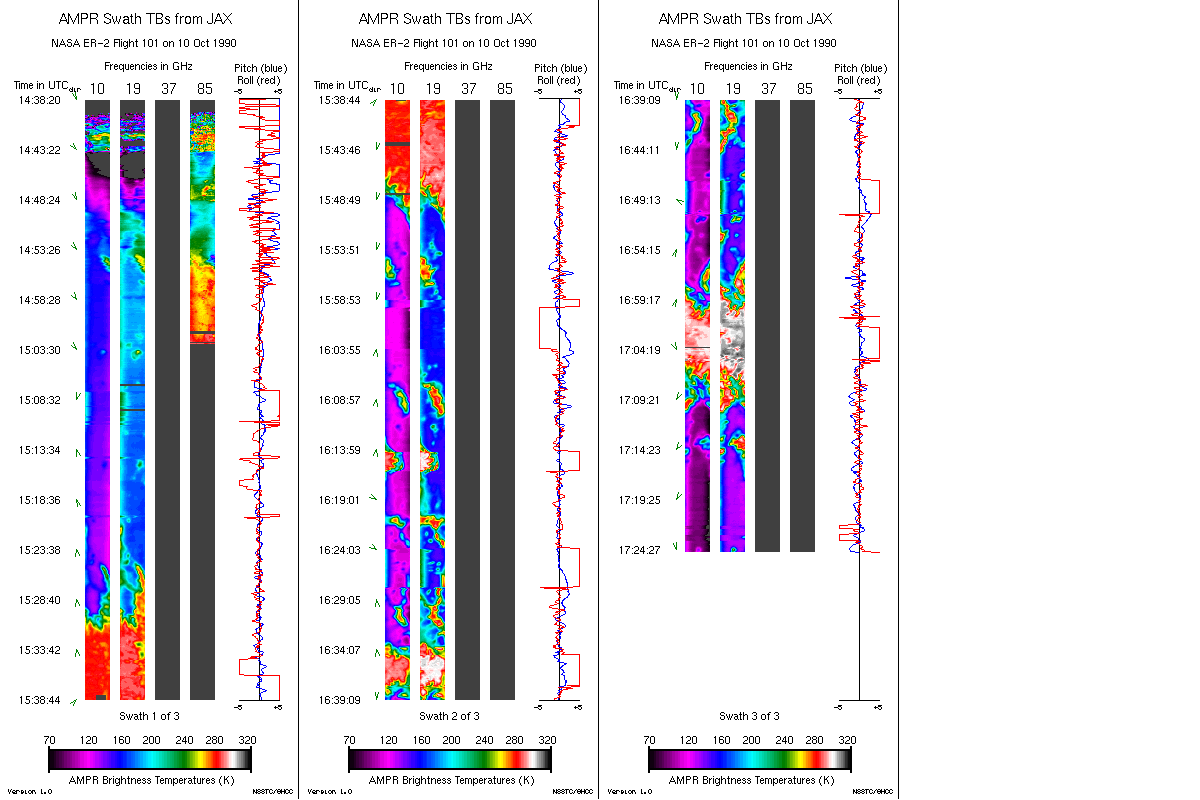
Federal
AMPR JACKSONVILLE BRIGHTNESS TEMPERATURE (TB) V2
National Aeronautics and Space Administration —
The Advanced Microwave Precipitation Radiometer (AMPR) was deployed in Jacksonville, FL for the initial AMPR instrument validation. AMPR data were collected at four... -
Federal
ESMR/Nimbus-5 Images of Brightness Temperature on 70 mm Film V001 (ESMRN5IM) at GES DISC
National Aeronautics and Space Administration —
ESMRN5IM is the Nimbus-5 Electrically Scanning Microwave Radiometer (ESMR) data product containing daily brightness temperature images from 70-mm photofacsimile film... -
Federal
Aquarius L3 Weekly Polar-Gridded Brightness Temperature and Sea Surface Salinity V005
National Aeronautics and Space Administration —
The data set consists of weekly gridded Level-3 products of Aquarius L-band radiometer brightness temperature (TB) observations and Sea Surface Salinity (SSS)... -
Federal
SMAP Enhanced L3 Radiometer Global and Polar Grid Daily 9 km EASE-Grid Soil Moisture V006
National Aeronautics and Space Administration —
This enhanced Level-3 (L3) soil moisture product provides a composite of daily estimates of global land surface conditions retrieved by the Soil Moisture Active... -
Federal
AMSR-E/Aqua Daily L3 6.25 km 89 GHz Brightness Temperature Polar Grids V003
National Aeronautics and Space Administration —
This Level-3 gridded product (AE_SI6) includes brightness temperatures at 89.0 GHz. Data are mapped to a polar stereographic grid at 6.25 km spatial resolution. This... -
Federal
NOAA Fundamental Climate Data Record (CDR) of AMSU-B and MHS Brightness Temperature, Version 1
National Oceanic and Atmospheric Administration, Department of Commerce —
The NOAA Climate Data Record (CDR) of Advanced Microwave Sounding Unit-B (AMSU-B) and Microwave Humidity Sounder (MHS) brightness temperature (Tb) in "window... -
Federal
DMSP SSM/I- Microwave Imager
National Oceanic and Atmospheric Administration, Department of Commerce —
The SSM/I is a seven-channel, four frequency, linearly-polarized, passive microwave radiometric system which measures atmospheric, ocean and terrain microwave... -
Federal
BASE Temperature Data Record (TDR) from the SSM/I and SSMIS Sensors, CSU Version 1
National Oceanic and Atmospheric Administration, Department of Commerce —
The BASE Temperature Data Record (TDR) dataset from Colorado State University (CSU) is a collection of the raw unprocessed antenna temperature data that has been... -
Federal
AMPR FIRE III ACE V1
National Aeronautics and Space Administration —
The Advanced Microwave Precipitation Radiometer (AMPR) was deployed during the First ISCCP Regional Experiment-III Arctic Cloud Experiment (FIRE-III/ACE). AMPR data... -
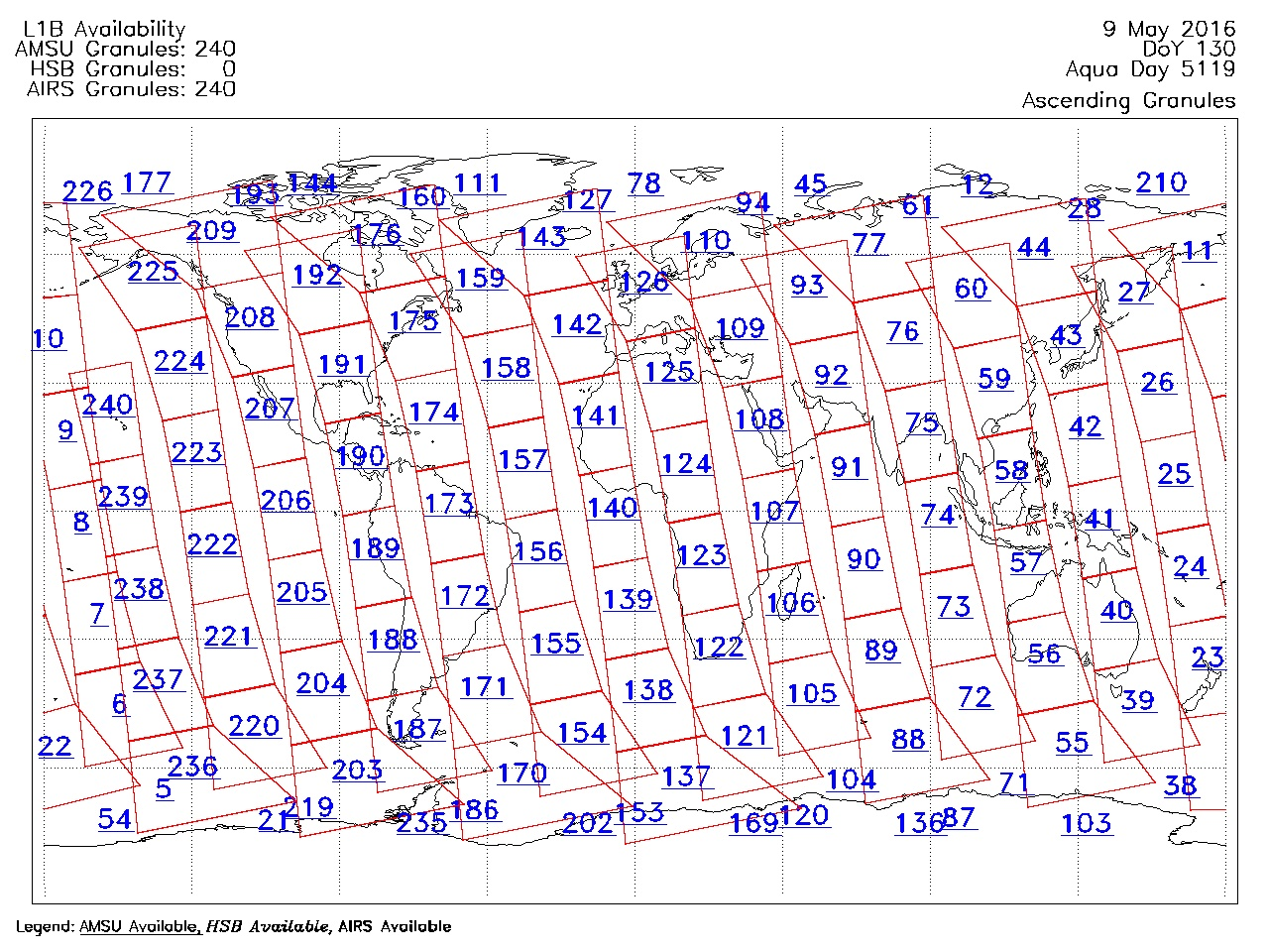
Federal
AIRS/Aqua Granule map product V005 (AIRXAMAP) at GES DISC
National Aeronautics and Space Administration —
The Atmospheric Infrared Sounder (AIRS) is a grating spectrometer (R = 1200) aboard the second Earth Observing System (EOS) polar-orbiting platform, EOS Aqua. In...

Official websites use .gov
A
.gov website belongs to an official government
organization in the United States.
Secure .gov websites use HTTPS
A
lock (
) or https:// means you’ve safely connected to
the .gov website. Share sensitive information only on official,
secure websites.