

MSU Ch 2/3 Daily Lower Troposphere Temps with Limb93 Correction L3 1 day 2.5 degree x 2.5 degree V001 (MSULTT) at GES DISC
Access & Use Information
Public: This dataset is intended for public access and use.
License: No license information was provided. If this work was prepared by an officer or employee of the United States government as part of that person's official duties it is considered a U.S. Government Work.
Downloads & Resources
-
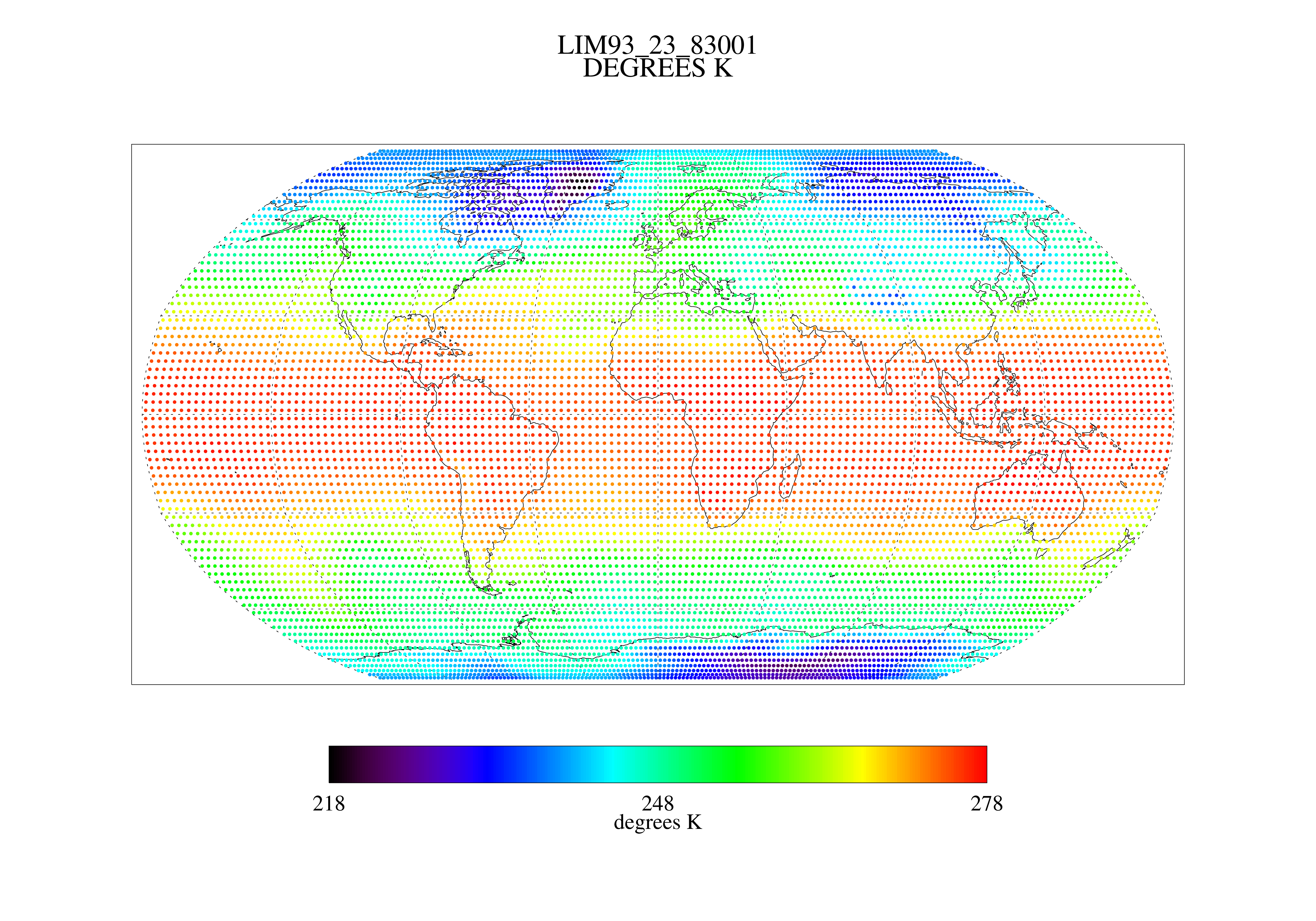
Get a related visualizationPNG
MSULTT_001.png
-
This dataset's landing pageHTML
Access the dataset landing page from the GES DISC website.
-
Download this dataset through a directory mapHTML
Access the data via HTTPS.
-
View this dataset's read me documentPDF
MSU Limb93 Data Documentation
-
View documentation related to this datasetPDF
This is an MSU legacy data guide. Some information may be obsolete.
-
Landing PageLanding Page
Dates
| Metadata Created Date | November 12, 2020 |
|---|---|
| Metadata Updated Date | August 23, 2025 |
Metadata Source
- Data.json Data.json Metadata
Harvested from NASA Data.json
Additional Metadata
| Resource Type | Dataset |
|---|---|
| Metadata Created Date | November 12, 2020 |
| Metadata Updated Date | August 23, 2025 |
| Publisher | NASA/GSFC/SED/ESD/GCDC/GESDISC |
| Maintainer | |
| Identifier | C1261530310-GES_DISC |
| Data First Published | 1979-01-01 |
| Language | en-US |
| Data Last Modified | 2025-07-17 |
| Category | TOVS Pathfinder, geospatial |
| Public Access Level | public |
| Bureau Code | 026:00 |
| Metadata Context | https://project-open-data.cio.gov/v1.1/schema/catalog.jsonld |
| Schema Version | https://project-open-data.cio.gov/v1.1/schema |
| Catalog Describedby | https://project-open-data.cio.gov/v1.1/schema/catalog.json |
| Harvest Object Id | f617e2df-6fbe-4e0a-9aba-bae004805bda |
| Harvest Source Id | 58f92550-7a01-4f00-b1b2-8dc953bd598f |
| Harvest Source Title | NASA Data.json |
| Homepage URL | https://cmr.earthdata.nasa.gov:443/search/concepts/C1261530310-GES_DISC.html |
| Metadata Type | geospatial |
| Old Spatial | -180.0 -89.0 180.0 89.0 |
| Program Code | 026:001 |
| Source Datajson Identifier | True |
| Source Hash | a5dd7861fd8249d12409cadbf3c8bfa94f33c6b7e38100eed7d4209a099e439d |
| Source Schema Version | 1.1 |
| Spatial | |
| Temporal | 1979-01-01T00:00:00Z/1994-12-31T23:59:59.999Z |
Didn't find what you're looking for? Suggest a dataset here.