
-
Federal
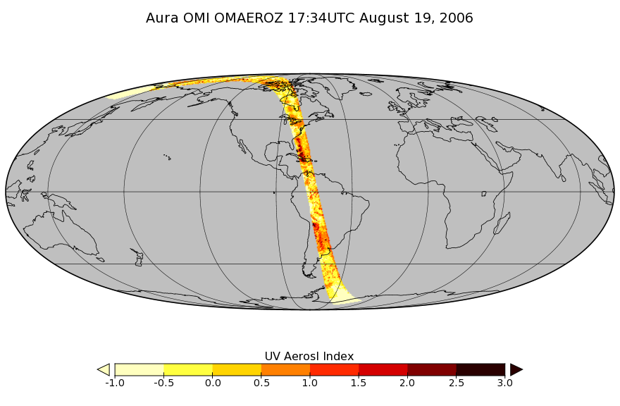
OMI/Aura Aerosol product Multi-wavelength Algorithm Zoomed 1-Orbit L2 Swath 13x12km V003 (OMAEROZ) at GES DISC
National Aeronautics and Space Administration —
The reprocessed OMI/Aura Level-2 Zoomed Aerosol data product OMAEROZ at 13x12 km resolution have been made available from the NASA Goddard Earth Sciences Data and... -
Federal
OLCI+SLSTR/Sentinel-3A L2 Surface Reflectance and Aerosol parameters over Land
National Aeronautics and Space Administration —
The OLCI+SLSTR/Sentinel-3A L2 Surface Reflectance and Aerosol parameters over Land product with shortname S3A_SY_2_SYN, is generated by combining data acquired by the... -
Federal
OLCI/Sentinel-3A L1 Reduced Resolution Top of Atmosphere Reflectance
National Aeronautics and Space Administration —
The OLCI/Sentinel-3A L1 Reduced Resolution Top of Atmosphere Reflectance, S3A_OL_1_ERR is generated from the data aquired by the Ocean and Land Colour Instrument... -
Federal
OMI/Aura Chlorine Dioxide (OClO) Total Column 1-orbit L2 Swath 13x24 km V003 (OMOCLO) at GES DISC
National Aeronautics and Space Administration —
The Aura Ozone Monitoring Instrument (OMI) collection-3 Chlorine Dioxide Product OMOCLO is now available from the NASA Goddard Earth Sciences Data and Information... -
Federal
OCO-2 Level 1A collated, parsed, science or calibration data, Retrospective Processing V11r (OCO2_L1aIn_Sample) at GES DISC
National Aeronautics and Space Administration —
Version 11r is the current version of the data set. Older versions will no longer be available and are superseded by Version 11r. The Orbiting Carbon Observatory is... -
Federal
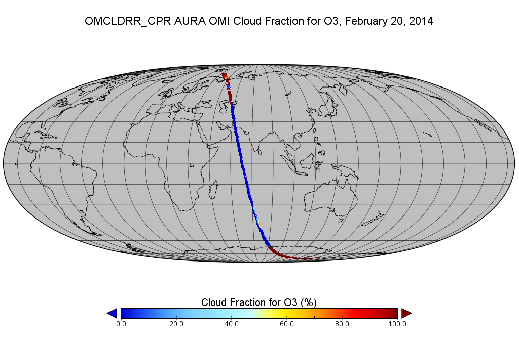
OMI/Aura Cloud Pressure and Fraction (Raman Scattering) 200-km swath subset along CloudSat track V003 (OMCLDRR_CPR) at GES DISC
National Aeronautics and Space Administration —
This is the OMI/Aura Cloud Pressure and Fraction (Raman Scattering) subset along CloudSat tracks, for the purposes of the A-Train mission. The original data product... -
Federal
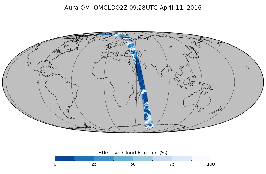
OMI/Aura Cloud Pressure and Fraction (O2-O2 Absorption) Zoomed 1-Orbit L2 Swath 13x12km V003 (OMCLDO2Z) at GES DISC
National Aeronautics and Space Administration —
The reprocessed Aura Ozone Monitoring Instrument (OMI) Level-2 zoomed cloud data product OMCLDO2Z at 13x12 km resolution is now available from the NASA Goddard Earth... -
Federal
OCO-3 Level 2 CO2 prior based on CO2 monthly flask record, global meteorology, and age of air, Retrospective Processing V11r (OCO3_L2_CO2Prior) at GES DISC
National Aeronautics and Space Administration —
Version 11r is the current version of the data set. Older versions will no longer be available and are superseded by Version 11r. The Orbiting Carbon Observatory -3... -
Federal
OCO-3 Level 2 spatially ordered geolocated retrievals screened using the A-band Preprocessor, Forward Processing V10 (OCO3_L2_ABand) at GES DISC
National Aeronautics and Space Administration —
Version 10 is the current version of the data set. Older versions will no longer be available and are superseded by Version 10. The Orbiting Carbon Observatory -3... -
Federal
OCO-3 Level 1B calibrated, geolocated calibration spectra, Retrospective Processing V10r (OCO3_L1B_Calibration) at GES DISC
National Aeronautics and Space Administration —
Version 10r is the current version of the data set. Older versions will no longer be available and are superseded by Version 10r. The Orbiting Carbon Observatory -3... -
Federal
OCO-3 Level 1B calibrated, geolocated calibration spectra, Retrospective Processing V11r (OCO3_L1B_Calibration) at GES DISC
National Aeronautics and Space Administration —
Version 11r is the current version of the data set. Older versions will no longer be available and are superseded by Version 11r. The Orbiting Carbon Observatory -3... -
Federal
OCO-3 Level 1B calibrated, geolocated science spectra, Forward Processing V10 (OCO3_L1B_Science) at GES DISC
National Aeronautics and Space Administration —
Version 10 is the current version of the data set. Older versions will no longer be available and are superseded by Version 10. The Orbiting Carbon Observatory -3... -
Federal
Northwest Atlantic and northeast Pacific oceans measurements collected during Sea Education Association (SEA) cruises
National Aeronautics and Space Administration —
Measurements made in the northwest Atlantic and northeast Pacific oceans between 2008 and 2009. -
Federal
ROSETTA-ORBITER 67P RSI 1/2/3 COMET ESCORT 3 0902 V1.0
National Aeronautics and Space Administration —
This is a Rosetta Radio Science data set, collected during the COMET ESCORT 3 phase 2015-07-01 to 2015-10-21. It is a Global Gravity measurement at the comet 67P and... -
Federal
Voyager 1 48-s Triaxial Fluxgate Magnetometer (MAG) Magnetic Field Data Near and Beyond Termination Shock in ASCII Format
National Aeronautics and Space Administration —
The main science objectives for the VOYAGER interplanetary mission are as \nfollows: \n- investigate the structure of the solar wind magnetic fields and plasma in... -
Federal
Voyager 1 Jupiter Ephemeris in System III (1965) Coordinates, Version 1.1, 96 s Browse Data
National Aeronautics and Space Administration —
- Data Set Overview\n =================\n\n Version 1.1\n ===========\n\nThe SEDR based Data provided as Part of this Data Set were originally...
-
Federal
ROSETTA-ORBITER 67P RSI 1/2/3 COMET ESCORT 2 0702 V1.0
National Aeronautics and Space Administration —
This is a Rosetta Radio Science data set, collected during the COMET ESCORT 2 phase 2015-03-11 to 2015-06-30. It is a Global Gravity measurement at the comet 67P and... -
Federal
ROSETTA-ORBITER 67P OSIWAC 2 PRL-MTP001 EDR V3.0
National Aeronautics and Space Administration —
This CODMAC level 2 data set contains uncalibrated image data in DN unit, acquired by the OSIRIS Wide Angle Camera on the Rosetta spacecraft during the PRELANDING... -
Federal
VG2 NEP MAG RESAMP SUMMARY HELIOGRAPHIC COORDS 48SEC V1.0
National Aeronautics and Space Administration —
This data set includes data from the Low Field Magnetometer (LFM) during the inbound Neptune encounter beginning in the solar wind and continuing until the first... -
Federal
ROSETTA-ORBITER 67P OSIWAC 4 ESC4-MTP023 RDR V1.0
National Aeronautics and Space Administration —
This CODMAC level 4 data set contains radiometric calibrated and geometric distortion corrected (resampled) image data in W/m^2/sr/nm acquired by the OSIRIS Wide...

Official websites use .gov
A
.gov website belongs to an official government
organization in the United States.
Secure .gov websites use HTTPS
A
lock (
) or https:// means you’ve safely connected to
the .gov website. Share sensitive information only on official,
secure websites.