
-
Federal
ROSETTA-ORBITER 67P SREM 5 PRELANDING MTP009 V1.0
National Aeronautics and Space Administration —
This data set contains derived electron and proton flux energies in MeV from the Standard Radiation Environment Monitor (SREM) instrument on the Rosetta spacecraft,... -
Federal
ROSETTA-ORBITER 67P RSI 1/2/3 COMET ESCORT 1 0510 V1.0
National Aeronautics and Space Administration —
This is a Rosetta Radio Science data set, collected during the COMET ESCORT 1 phase 2014-11-20 to 2015-03-10. It is a Global Gravity measurement at the comet 67P and... -
Federal
ROSETTA-ORBITER COMET ESCORT 2 OSIWAC 2 EDR MTP015 V2.0
National Aeronautics and Space Administration —
This data set contains images acquired by the OSIRIS Wide Angle Camera during the COMET ESCORT 2 phase of the Rosetta mission at the comet 67P, covering the period... -
Federal
ROSETTA-ORBITER 67P NAVCAM 2 ROSETTA EXTENSION 1 MTP027 V1.0
National Aeronautics and Space Administration —
This dataset contains ROSETTA NAVCAM RAW DATA of the Escort Phase 4 from 8th March 2016 to 5th Apr 2016 when at the vicinity of target 67P/CG. -
Federal
MARS EXPRESS MARS MRS 1/2/3 EXTENDED MISSION 7 4147 V1.0
National Aeronautics and Space Administration —
This is a Mars Express Radio Science data set, collected during the extended mission phase 2019-01-01 to 2020-12-31. It is a Occultation measurement and covers the... -
Federal
ROSETTA-ORBITER 67P MIRO 3 ESC1 V3.0
National Aeronautics and Space Administration —
This data set contains Spectroscopic and Continuum, level 3 data, in the form of table files, taken during the ROSETTA COMET ESCORT 1 phase of the Rosetta mission to... -
Federal
Voyager 1 Hourly Magnetic Field Data from 1977-1989
National Aeronautics and Space Administration —
This data set contains hour averages of the interplanetary magnetic field (IMF) measurements obtained by the triaxial fluxgate magnetometer (MAG) experiment on... -
Federal
GRAIL MOON LGRS DERIVED GRAVITY SCIENCE DATA PRODUCTS V1.0
National Aeronautics and Space Administration —
This data set contains archival derived science data, acquired from the Lunar Gravity Ranging System (LGRS) on the two spacecraft comprising the Gravity Recovery and... -
Federal
ROSETTA-ORBITER LUTETIA MIRO 2 AST2 LUTETIA V1.0
National Aeronautics and Space Administration —
This data set contains Spectroscopic, Continuum and Engineering data, in the form of table files, taken during the LUTETIA flyby phase of the Rosetta mission by the... -
Federal
SMEX04 Site Photographs, Arizona, Version 1
National Aeronautics and Space Administration —
Notice to Data Users: The documentation for this data set was provided solely by the Principal Investigator(s) and was not further developed, thoroughly reviewed, or... -
Federal
ABoVE/ASCENDS: Atmospheric Backscattering Coefficient Profiles from CO2 Sounder, 2017
National Aeronautics and Space Administration —
This dataset provides atmospheric backscattering coefficient profiles collected during Active Sensing of CO2 Emissions over Nights, Days, and Seasons (ASCENDS)... -
Federal
SMEX03 QuikSCAT/SeaWinds Backscatter Data, Oklahoma, Version 1
National Aeronautics and Space Administration —
This data set includes data collected over the Soil Moisture Experiment 2003 (SMEX03) areas of Alabama, Georgia, and Oklahoma, USA. -
Federal
Satellite SPOT Extracted Data (FIFE)
National Aeronautics and Space Administration —
The Site Reflectances Extracted from SPOT HRV Imagery Data Set contains the average instrument corrected spectral radiances for each of the spectral bands (3 in XS... -
Federal
Satellite Laser Ranging (SLR) Predictions from NASA CDDIS
National Aeronautics and Space Administration —
Predicted satellite orbits for Satellite Laser Ranging (SLR) tracking of satellites equipped with corner cube retroreflectors. SLR stations download these prediction... -
Federal
Satellite Laser Ranging (SLR) data from NASA CDDIS
National Aeronautics and Space Administration —
In Satellite Laser Ranging (SLR), a short pulse of coherent light generated by a laser (Light Amplification by Stimulated Emission of Radiation) is transmitted in a... -
Federal
SatCORPS CERES GEO Edition 4 GOES-13 Southern Hemisphere Version 1.0
National Aeronautics and Space Administration —
CER_GEO_Ed4_GOE13_SH_V01 is the Satellite Cloud and Radiation Property retrieval System (SatCORPS) Clouds and the Earth's Radiant Energy System (CERES) Geostationary... -
Federal
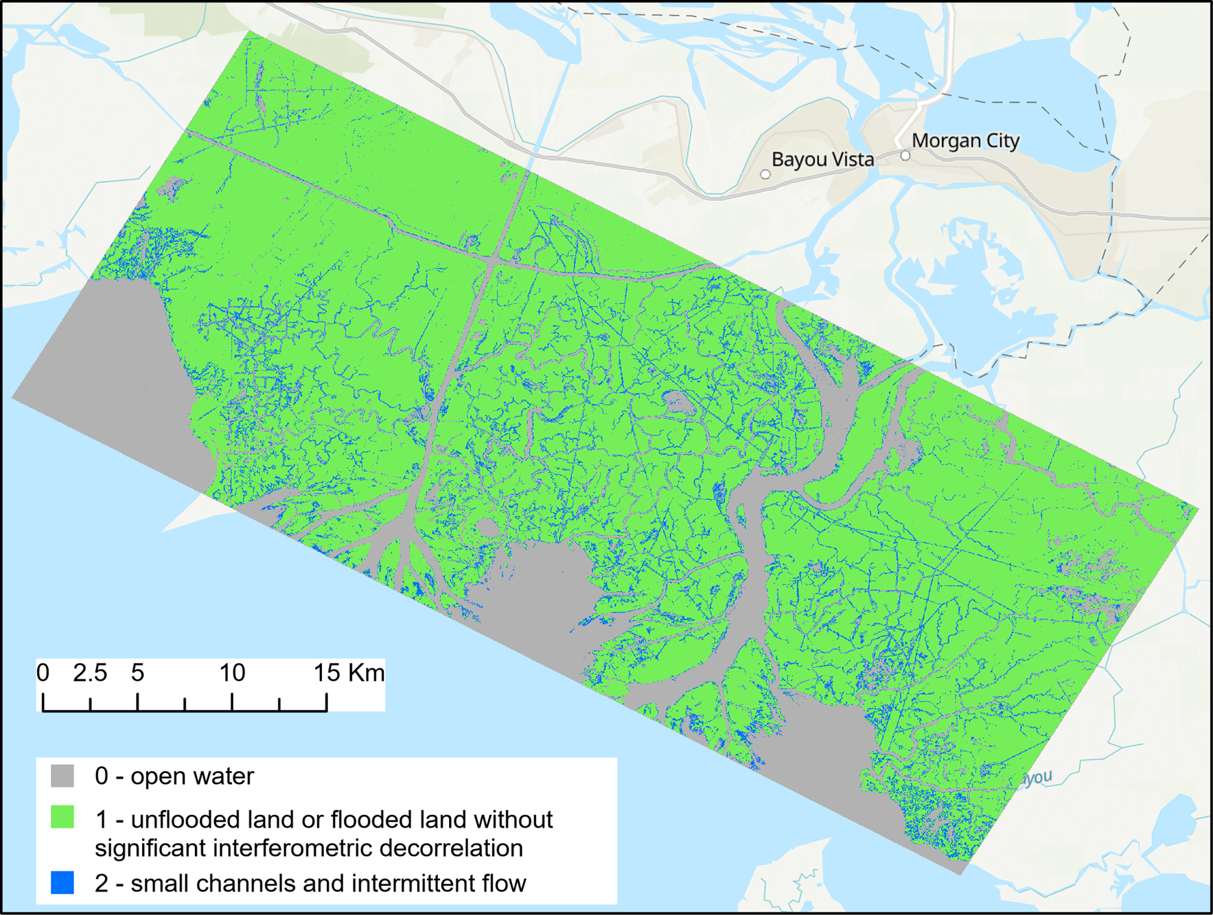
Pre-Delta-X: UAVSAR Georeferenced Channel Maps, Atchafalaya Basin, LA, USA, 2016, V2
National Aeronautics and Space Administration —
This dataset provides spatial data on water channels in the estuary of the Atchafalaya Basin of the Mississippi River Delta of coastal Louisiana. These Level-3 (L3)... -
Federal
OMI/Aura Level 2 Sulphur Dioxide (SO2) Trace Gas Column Data 1-Orbit Subset and Collocated Swath along CloudSat V003 (OMSO2_CPR) at GES DISC
National Aeronautics and Space Administration —
This is a CloudSat-collocated subset of the original product OMSO2, for the purposes of the A-Train mission. The goal of the subset is to select and return OMI data... -
Federal
OCO-3 Level 1A collated, parsed, science or calibration data V11 (OCO3_L1aIn_Sample) at GES DISC
National Aeronautics and Space Administration —
Version 11 is the current version of the data set. Older versions will no longer be available and are superseded by Version 11. The Orbiting Carbon Observatory is the...

Official websites use .gov
A
.gov website belongs to an official government
organization in the United States.
Secure .gov websites use HTTPS
A
lock (
) or https:// means you’ve safely connected to
the .gov website. Share sensitive information only on official,
secure websites.