
-
Federal
Optical Thickness Data: Ground (OTTER)
National Aeronautics and Space Administration —
Field sun photometer data collected from 1990 through 1991 is used to provide quantitative atmospheric correction to remotely sensed data of forest reflectance and... -
Federal
OMPS-N21 LP NRT Aerosol Extinction Vertical Profile swath multi-wavelength orbital 3slit
National Aeronautics and Space Administration —
The OMPS-N21 Level 2 LP Aerosol Extinction Vertical Profile swath level 2 3slit (AER) product contains the retrieved aerosol extinction coefficients measured by the... -
Federal
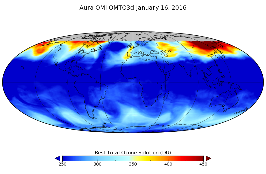
OMI/Aura TOMS-Like Ozone, Aerosol Index, Cloud Radiance Fraction L3 1 day 1 degree x 1 degree V3 (OMTO3d) at GES DISC
National Aeronautics and Space Administration —
The OMI science team produces this Level-3 daily global TOMS-Like Total Column Ozone gridded product OMTO3d (1 deg Lat/Lon grids). The OMTO3d product is produced by... -
Federal
OMI/Aura Near UV Aerosol Optical Depth and Single Scattering Albedo 1-orbit L2 Swath 13x24 km V003 NRT
National Aeronautics and Space Administration —
The OMI/Aura level-2 near UV Aerosol data product 'OMAERUV', recently re-processed using an enhanced algorithm, is now released (April 2012) to the public. The data... -
Federal
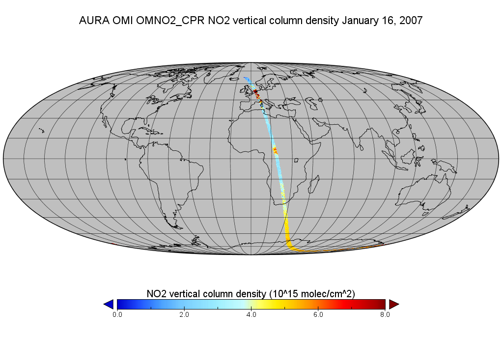
OMI/Aura Level 2 Nitrogen Dioxide (NO2) Trace Gas Column Data 1-Orbit subset Swath along CloudSat track 1-Orbit Swath 13x24 km
National Aeronautics and Space Administration —
This is a CloudSat-collocated subset of the original product OMNO2, for the purposes of the A-Train mission. The goal of the subset is to select and return OMI data... -
Federal
OMI/Aura Level 1B Solar Irradiances V003 (OML1BIRR) at GES DISC
National Aeronautics and Space Administration —
The OMI Level 1B solar irradiance product is the radiometrically calibrated and geolocated measurements of the UV and Visible channels of the spectral solar... -
Federal
OCO-3 Level 2 spatially ordered geolocated retrievals screened using the A-band Preprocessor, Forward Processing V11 (OCO3_L2_ABand) at GES DISC
National Aeronautics and Space Administration —
Version 11 is the current version of the data set. Older versions will no longer be available and are superseded by Version 11. The Orbiting Carbon Observatory -3... -
Federal
NRT VIIRS/MODIS Dark Target Deep Blue Aerosol AOD with QA for Data Assimilation 24-Hour 1 Degree L3
National Aeronautics and Space Administration —
The VIIRS/MODIS L3 product is designed to facilitate both evaluation and NRT applications for the NASA Dark Target (DT) and Deep Blue (DB) aerosol products for both... -
Federal
Portable Remote Imaging Spectrometer (PRISM) COral Reef Airborne Laboratory (CORAL) Regional Reflectance Data
National Aeronautics and Space Administration —
Flight line reflectance measurements from the Portable Remote Imaging Spectrometer (PRISM) instrument aboard the Tempus Applied Solutions Gulfstream-IV (G-IV)... -
Federal
Portable Remote Imaging SpectroMeter (PRISM) from Elkhorn Slough to Monterey Bay, California
National Aeronautics and Space Administration —
The estuarine waters of Elkhorn Slough terminating in Monterey Bay, California present an excellent study site for testing the limits of hyperspectral imaging... -
Federal
QuikSCAT Level 2B Ocean Wind Vectors in 12.5km Slice Composites Version 3.1
National Aeronautics and Space Administration —
This dataset contains the latest reprocessed version 3.1 of the Level 2B science-quality ocean surface wind vector retrievals from the QuikSCAT scatterometer. The... -
Federal
OCO-2 Level 1A collated, parsed, calibration data V11.2 (OCO2_L1aIn_Pixel) at GES DISC
National Aeronautics and Space Administration —
Version 11.2 is the current version of the data set. Older versions will no longer be available and are superseded by Version 11.2. The Orbiting Carbon Observatory is... -
Federal
OCO-2 Level 0 spacecraft attitude data V11.2 (OCO2_Att) at GES DISC
National Aeronautics and Space Administration —
Version 11.2 is the current version of the data set. Older versions will no longer be available and are superseded by Version 11.2 The Orbiting Carbon Observatory is... -
Federal
Ocean color calibration and validation measurements off the New Jersey and New York coasts
National Aeronautics and Space Administration —
Measurements made off the New Jersey and New York coasts between 2005 and 2009. -
Federal
OMPS/NPP PCA SO2 Total Column 1-Orbit L2 Swath 50x50km NRT
National Aeronautics and Space Administration —
The OMPS-NPP L2 NM Sulfur Dioxide (SO2) Total and Tropospheric Column swath orbital collection 2 version 2.0 product contains the retrieved sulfur dioxide (SO2)... -
Federal
OMPS-NPP L2 NM Nitrogen Dioxide (NO2) Total and Tropospheric Column swath orbital V2 (OMPS_NPP_NMNO2_L2) at GES DISC
National Aeronautics and Space Administration —
The OMPS-NPP L2 NM Nitrogen Dioxide (NO2) Total and Tropospheric Column swath orbital collection 2 version 2.0 product contains the retrieved nitrogen dioxide (NO2)... -
Federal
OMPS-NPP L2 NP Ozone (O3) Vertical Profile swath orbital NRT
National Aeronautics and Space Administration —
The OMPS-NPP L2 NP Ozone (O3) Total Column swath orbital product provides ozone profile retrievals from the Ozone Mapping and Profiling Suite (OMPS) Nadir-Profiler... -
Federal
OMI/Aura Sulphur Dioxide (SO2) Total Column 1-orbit L2 Swath 13x24 km V003 NRT
National Aeronautics and Space Administration —
The Ozone Monitoring Instrument (OMI) was launched aboard the EOS-Aura satellite on July 15, 2004 (1:38 pm equator crossing time, ascending mode). OMI with its 2600... -
Federal
OMPS-N20 NM PCA SO2 Step 1 Total Column 1-Orbit L2 Swath 17x13km NRT
National Aeronautics and Space Administration —
The OMPS-N20 NM PCA SO2 Step1 Total Column 1-Orbit L2 Swath 17x13km collection 1 product contains the retrieved sulfur dioxide (SO2) measured by the Ozone Mapping and...

Official websites use .gov
A
.gov website belongs to an official government
organization in the United States.
Secure .gov websites use HTTPS
A
lock (
) or https:// means you’ve safely connected to
the .gov website. Share sensitive information only on official,
secure websites.