
-
Federal
CORONA Satellite Photographs from the U.S. Geological Survey
National Aeronautics and Space Administration —
The first generation of U.S. photo intelligence satellites collected more than 860,000 images of the Earth’s surface between 1960 and 1972. The classified military... -
Federal
OPERA Dynamic Surface Water Extent from Harmonized Landsat Sentinel-2 provisional product (Version 1)
National Aeronautics and Space Administration —
This dataset contains Level-3 Dynamic OPERA provisional surface water extent product version 1. The data are provisional surface water extent observations beginning... -
Federal
Poverty Mapping Project: Poverty and Food Security Case Studies
National Aeronautics and Space Administration —
The Poverty Mapping Project: Poverty and Food Security Case Studies data set consists of small area estimates of poverty, inequality, food security and related... -
Federal
Aircraft Scanners
National Aeronautics and Space Administration —
The National Aeronautics and Space Administration (NASA) Aircraft Scanners data set contains digital imagery acquired from several multispectral scanners, including... -
Federal
CDDIS_VLBI_data
National Aeronautics and Space Administration —
Very Long Baseline Interferometry (VLBI) is a geometric technique: it measures the time difference between the arrival at two Earth-based antennas of a radio... -
Federal
CLASIC07 Land Cover Classification Map V001
National Aeronautics and Space Administration —
This data set consists of land cover classification data derived from satellite imagery as part of the Cloud and Land Surface Interaction Campaign 2007 (CLASIC07).... -
Federal
SMAPVEX12 Land Cover Classification Map V001
National Aeronautics and Space Administration —
This data set consists of land cover classification data derived from satellite imagery as part of the Soil Moisture Active Passive Validation Experiment 2012... -
Federal
Global Multihazard Mortality Risks and Distribution
National Aeronautics and Space Administration —
The Global Multihazard Mortality Risks and Distribution is a 2.5 minute grid identifying and characterizing the nature of multihazard risk at the global scale. For... -
Federal
Land Cover Classification, Snow Cover, and Fractional Snow-Covered Area Maps from Maxar WorldView Satellite Images V001
National Aeronautics and Space Administration —
This data set includes: (1) fine-scale snow and land cover maps from two mountainous study sites in the Western U.S., produced using machine-learning models trained... -
Federal
Daily and Annual PM2.5, O3, and NO2 Concentrations at ZIP Codes for the Contiguous U.S., 2000-2016, v1.0
National Aeronautics and Space Administration —
The Daily and Annual PM2.5, O3, and NO2 Concentrations at ZIP Codes for the Contiguous U.S., 2000-2016, v1.0 data set contains daily and annual concentration... -
Federal
CLASIC07 Soil Texture Data V001
National Aeronautics and Space Administration —
This data set contains soil texture data obtained for the Cloud and Land Surface Interaction Campaign 2007 (CLASIC07). The original data were extracted from a multi-... -
Federal
SnowEx21 Prairie Station In Situ Dielectric Soil Moisture and Soil Temperature V001
National Aeronautics and Space Administration —
This data set consists of soil moisture and soil temperature measurements taken during the SnowEx 2021 field campaign. Soil moisture probes were deployed at 9... -
Federal
SMAPVEX12 Soil Texture Map V001
National Aeronautics and Space Administration —
This data set consists of soil texture classification data derived from field surveys as part of the Soil Moisture Active Passive Validation Experiment 2012... -
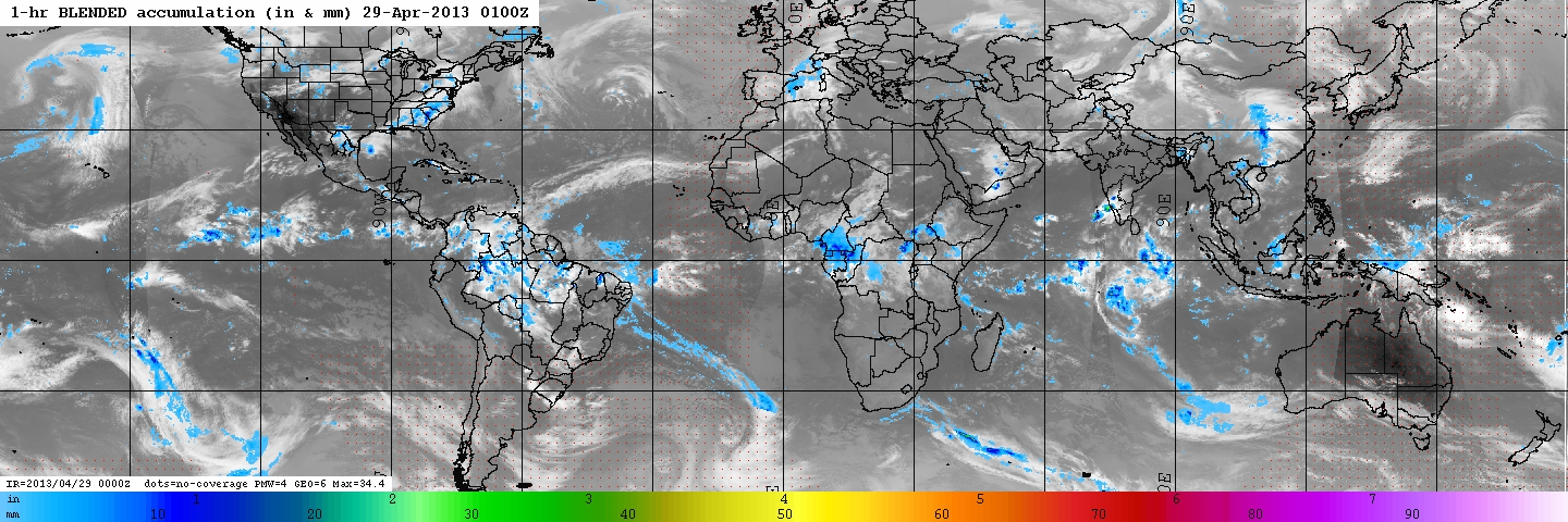
Federal
GPM Ground Validation Naval Research Laboratory (NRL) Near-Real Time Rain Rates IFloodS V1
National Aeronautics and Space Administration —
The GPM Ground Validation Naval Research Laboratory (NRL) Near-Real Time Rain Rates IFloodS data product was created for the GPM Iowa Flood Studies (IFloodS) field... -
Federal
SnowEx20 Grand Mesa In Situ Dielectric Soil Moisture V001
National Aeronautics and Space Administration —
This data set consists of soil moisture and soil temperature measurements taken during the SnowEx 2020 field campaign. Soil moisture probes were deployed at 10... -
Federal
SnowEx20 Grand Mesa Reference GIS Data Sets V001
National Aeronautics and Space Administration —
This data set contains geolocation information of the infrastructure locations for the SnowEx20 Intensive Observation Period (IOP) and Time Series (TS) campaigns.... -
Federal
SnowEx17 Laser Snow Microstructure Specific Surface Area Data V001
National Aeronautics and Space Administration —
This data set reports vertical profiles of snow reflectance, specific surface area (SSA), and optical equivalent diameter (grain size) at Grand Mesa, Colorado, USA, a... -
Federal
SnowEx23 Oct22 Laser Snow Microstructure Specific Surface Area Low-snow V001
National Aeronautics and Space Administration —
This data set reports vertical profiles of snow reflectance and specific surface area (SSA) collected in October 2022 as part of the NASA SnowEx 2023 Alaska field... -
Federal
SMAPVEX12 Soil Texture Map V001
National Aeronautics and Space Administration —
This data set consists of soil texture classification data derived from field surveys as part of the Soil Moisture Active Passive Validation Experiment 2012... -
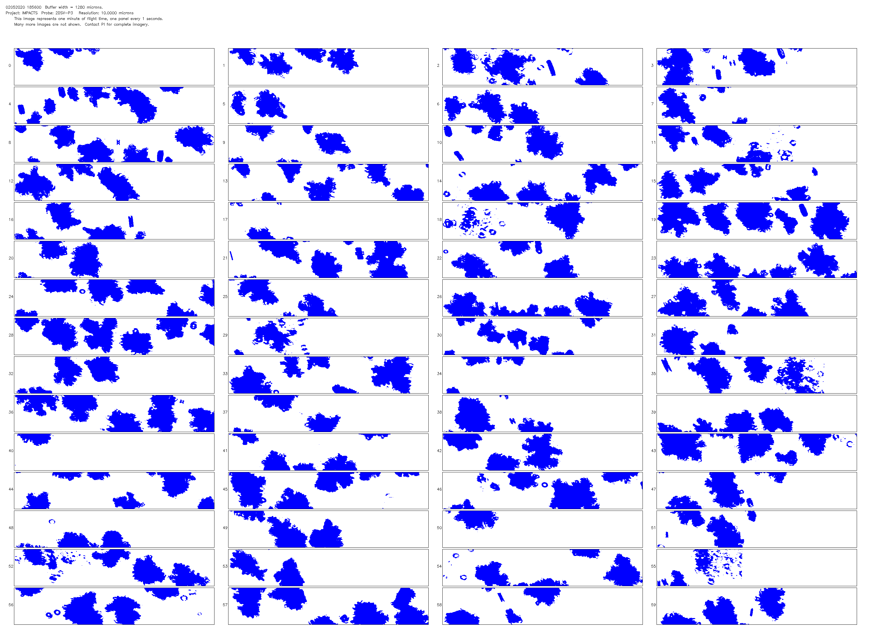
Federal
NCAR Particle Probes IMPACTS V1
National Aeronautics and Space Administration —
The NCAR Particle Probes IMPACTS dataset consists of data collected from six instruments on the NASA P-3 aircraft, the SPEC Hawkeye Cloud Particle Imager (CPI), the...

Official websites use .gov
A
.gov website belongs to an official government
organization in the United States.
Secure .gov websites use HTTPS
A
lock (
) or https:// means you’ve safely connected to
the .gov website. Share sensitive information only on official,
secure websites.