
-
Federal
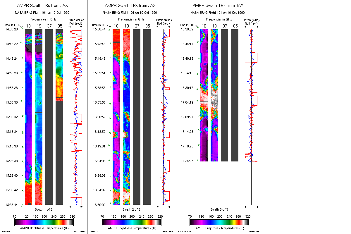
AMPR BRIGHTNESS TEMPERATURE CAMEX-1 V2
National Aeronautics and Space Administration —
The Advanced Microwave Precipitation Radiometer (AMPR) was deployed during the Convection and Moisture Experiments (CAMEX-1) conducted at Wallops Island, VA. AMPR... -
Federal
TROPICS07 L2A Unified Resolution Brightness Temperatures V0.2
National Aeronautics and Space Administration —
The "Time-Resolved Observations of Precipitation structure and storm Intensity with a Constellation of Smallsats" (TROPICS) mission has a goal of providing nearly... -
Federal
TROPICS01 Pathfinder L2A Unified Resolution Brightness Temperatures V1.0
National Aeronautics and Space Administration —
The "Time-Resolved Observations of Precipitation structure and storm Intensity with a Constellation of Smallsats" (TROPICS) mission has a goal of providing nearly... -
Federal
ESMR/Nimbus-5 Images of Brightness Temperature on 70 mm Film V001 (ESMRN5IM) at GES DISC
National Aeronautics and Space Administration —
ESMRN5IM is the Nimbus-5 Electrically Scanning Microwave Radiometer (ESMR) data product containing daily brightness temperature images from 70-mm photofacsimile film... -
Federal
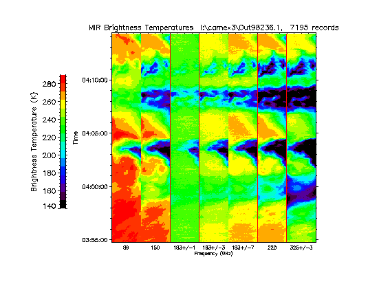
CAMEX-3 ER-2 Millimeter-wave Imaging Radiometer (MIR) V1
National Aeronautics and Space Administration —
The CAMEX-3 ER-2 Millimeter-wave Imaging Radiometer (MIR) dataset is a browse-only dataset containing plots of brightness temperature measurements collected by the... -
Federal
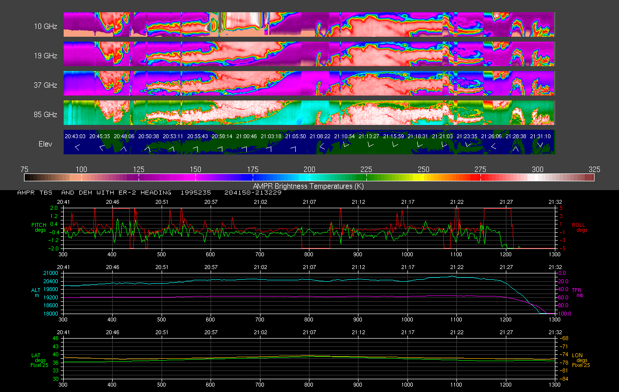
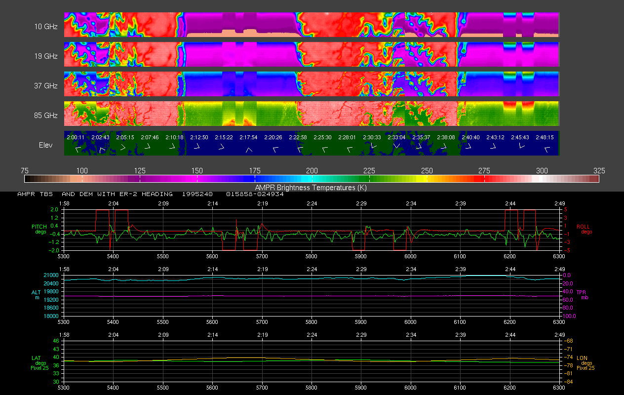
AMPR BRIGHTNESS TEMPERATURE CAMEX-2 V2
National Aeronautics and Space Administration —
The Advanced Microwave Precipitation Radiometer (AMPR) was deployed during the Convection and Moisture Experiment 2 (CAMEX-2). AMPR data were collected at a... -
Federal
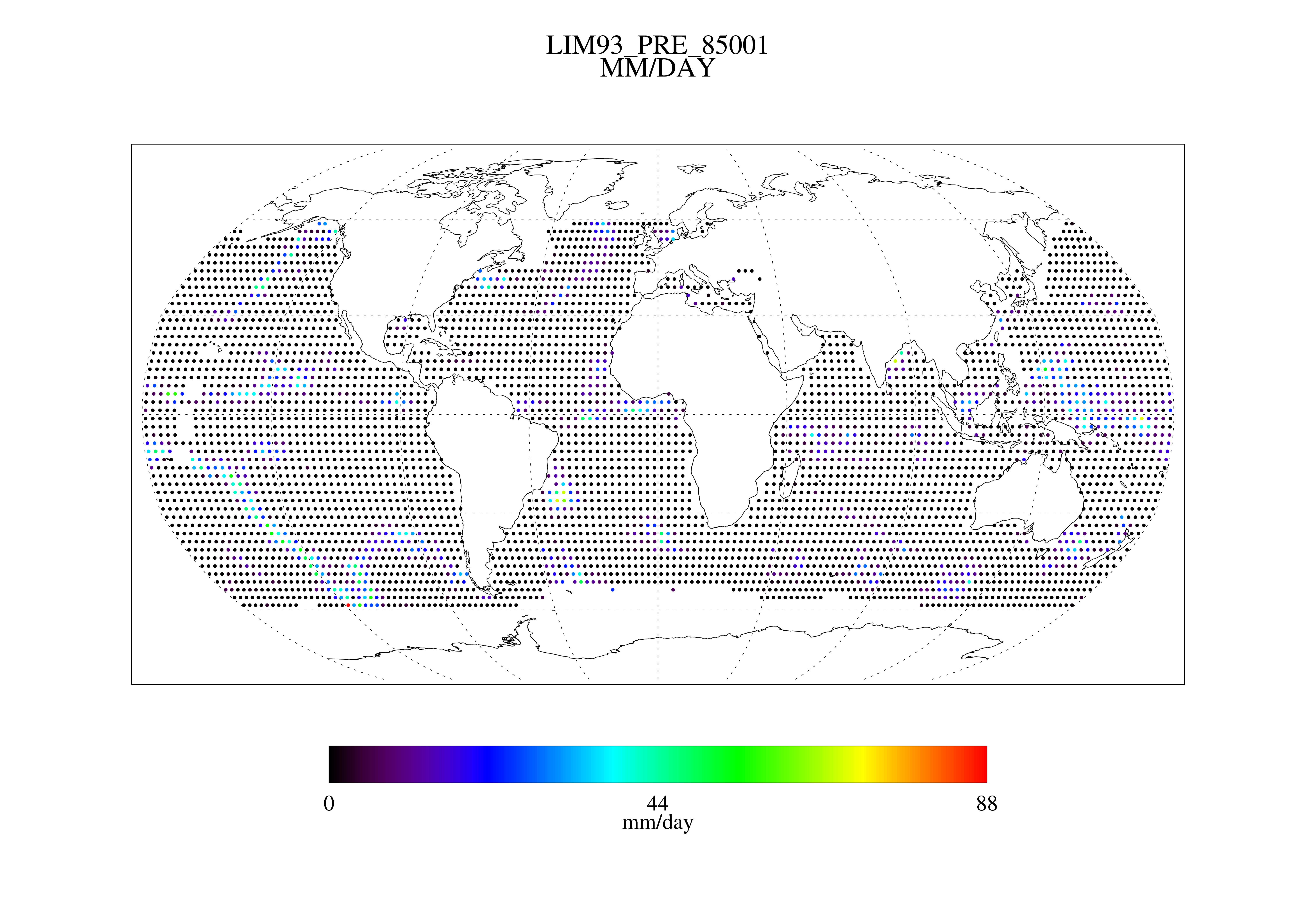
MSU Daily Oceanic Precipitation with Limb93 Correction L3 1 day 2.5 degree x 2.5 degree V001 (MSUOP) at GES DISC
National Aeronautics and Space Administration —
The Microwave Sounding Unit (MSU) Ocean Precipitation product (MSUOP) provides gridded upper tropospheric temperatures derived from MSU instruments on several... -
Federal
TOVS GLA MONTHLY GRIDS from NOAA-10 V01 (TOVSAMNG) at GES DISC
National Aeronautics and Space Administration —
This dataset (TOVSAMNG) contains the TIROS Operational Vertical Sounder (TOVS) level 3 geophysical parameters derived using data from NOAA-10 and the physical... -
Federal
TROPICS03 L2A Unified Resolution Brightness Temperatures V1.0
National Aeronautics and Space Administration —
The "Time-Resolved Observations of Precipitation structure and storm Intensity with a Constellation of Smallsats" (TROPICS) mission has a goal of providing nearly... -
Federal
TROPICS07 L2B Tropical Cyclone Intensity Estimate (TCIE) Algorithm V1.0
National Aeronautics and Space Administration —
The "Time-Resolved Observations of Precipitation structure and storm Intensity with a Constellation of Smallsats" (TROPICS) mission has a goal of providing nearly... -
Federal
TOVS GLA 5 DAY GRIDS from NOAA-9 V01 (TOVSA5NF) at GES DISC
National Aeronautics and Space Administration —
This dataset (TOVSA5NF) contains the TIROS Operational Vertical Sounder (TOVS) level 3 geophysical parameters derived using data from NOAA-9 and the physical... -
Federal
TROPICS06 L2A Unified Resolution Brightness Temperatures V1.0
National Aeronautics and Space Administration —
The "Time-Resolved Observations of Precipitation structure and storm Intensity with a Constellation of Smallsats" (TROPICS) mission has a goal of providing nearly... -
Federal
AMPR JACKSONVILLE BRIGHTNESS TEMPERATURE (TB) V2
National Aeronautics and Space Administration —
The Advanced Microwave Precipitation Radiometer (AMPR) was deployed in Jacksonville, FL for the initial AMPR instrument validation. AMPR data were collected at four... -
Federal
TROPICS01 Pathfinder L1B Orbital Geolocated Native-Resolution Brightness Temperatures V1.0
National Aeronautics and Space Administration —
The "Time-Resolved Observations of Precipitation structure and storm Intensity with a Constellation of Smallsats" (TROPICS) mission has a goal of providing nearly... -
Federal
SWOT Level 2 Radiometer Brightness Temperatures and Troposphere Operational Data Product Version 1.0
National Aeronautics and Space Administration —
The SWOT Level 2 Radiometer Brightness Temperatures and Troposphere Operational Geophysical Data Record (OGDR) Version 1.0 dataset produced by the Surface Water and... -
Federal
TROPICS05 L2B Tropical Cyclone Intensity Estimate (TCIE) Algorithm V1.0
National Aeronautics and Space Administration —
The "Time-Resolved Observations of Precipitation structure and storm Intensity with a Constellation of Smallsats" (TROPICS) mission has a goal of providing nearly... -
Federal
BASE Temperature Data Record (TDR) from the SSM/I and SSMIS Sensors, CSU Version 1
National Oceanic and Atmospheric Administration, Department of Commerce —
The BASE Temperature Data Record (TDR) dataset from Colorado State University (CSU) is a collection of the raw unprocessed antenna temperature data that has been... -
Federal
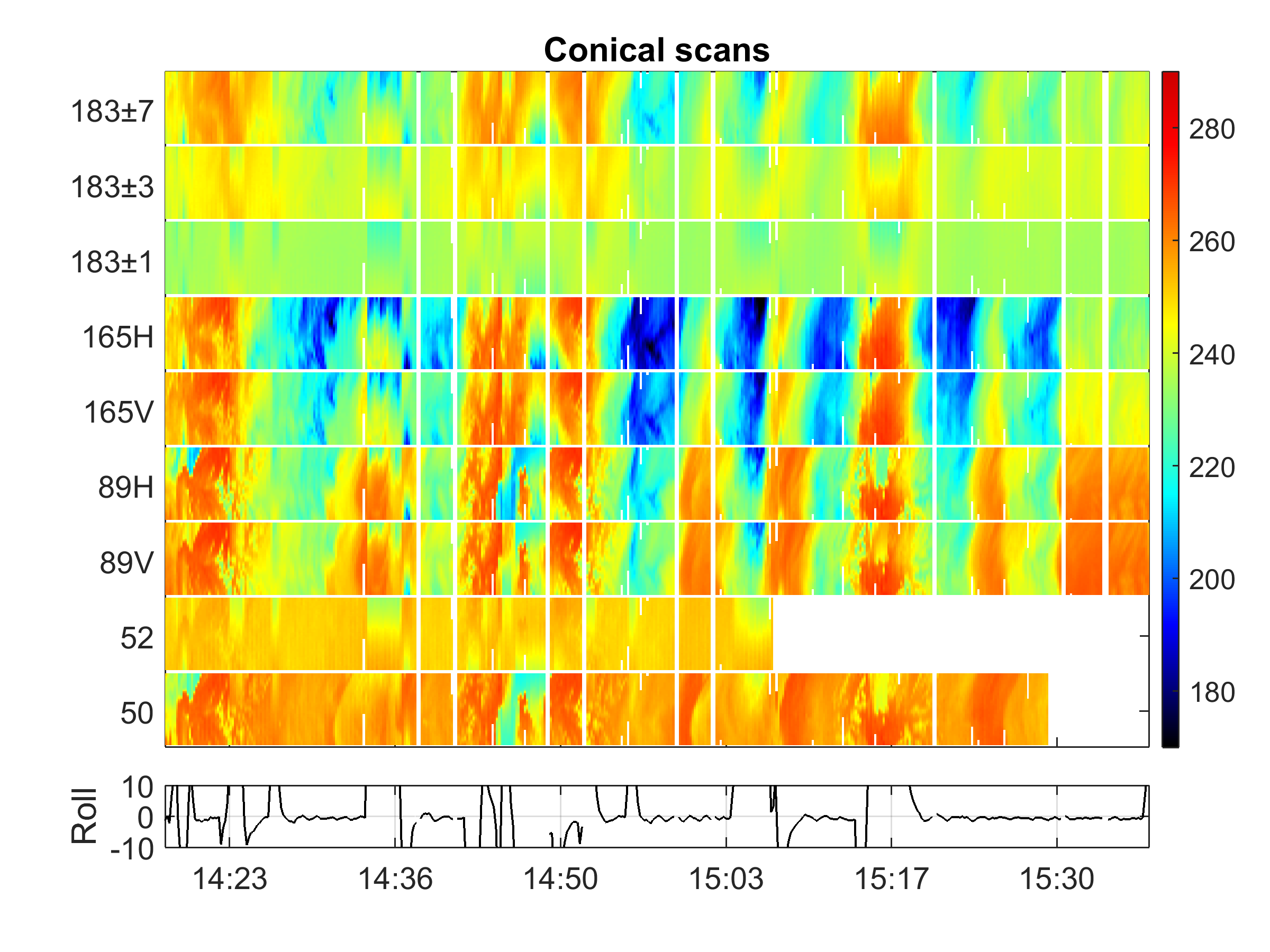
GPM Ground Validation Conical Scanning Millimeter-wave Imaging Radiometer (CoSMIR) OLYMPEX V1
National Aeronautics and Space Administration —
The GPM Ground Validation Conical Scanning Millimeter-wave Imaging Radiometer (CoSMIR) OLYMPEX dataset consists of brightness temperatures from 9 channels as measured... -
Federal
GPM GROUND VALIDATION CONICAL SCANNING MILLIMETER-WAVE IMAGING RADIOMETER (COSMIR) GCPEX V1
National Aeronautics and Space Administration —
The GPM Ground Validation Conical Scanning Millimeter-wave Imaging Radiometer (COSMIR) GCPEx dataset used the Conical Scanning Millimeter-wave Imaging Radiometer... -
Federal
OW ASCAT Ocean Surface Winds
National Oceanic and Atmospheric Administration, Department of Commerce —
The Advanced Scatterometer (ASCAT) sensor onboard the EUMETSAT MetOp polar-orbiting satellite provides ocean surface wind observations by means of radar...

Official websites use .gov
A
.gov website belongs to an official government
organization in the United States.
Secure .gov websites use HTTPS
A
lock (
) or https:// means you’ve safely connected to
the .gov website. Share sensitive information only on official,
secure websites.