
-
Federal
SWOT Level 2 Radiometer Brightness Temperatures and Troposphere Interim Data Product, Version 2.0 recent views
National Aeronautics and Space Administration —
The SWOT Level 2 Radiometer Brightness Temperatures and Troposphere Interim Geophysical Data Record (IGDR) Version 1.0 dataset produced by the Surface Water and Ocean... -
Federal
AVIRIS-Classic: L2 Calibrated Reflectance, Facility Instrument Collection recent views
National Aeronautics and Space Administration —
This dataset contains Level 2 (L2) orthocorrected reflectance from the Airborne Visible / Infrared Imaging Spectrometer (AVIRIS-Classic) instrument. This is the NASA... -
Federal
JASON-1 ENHANCED JASON MICROWAVE RADIOMETER recent views
National Aeronautics and Space Administration —
The enhanced Jason-1 Microwave Radiometer (JMR) corrections contains better wet tropospheric path delay corrections along with better land, rain and ice flagging for... -
Federal
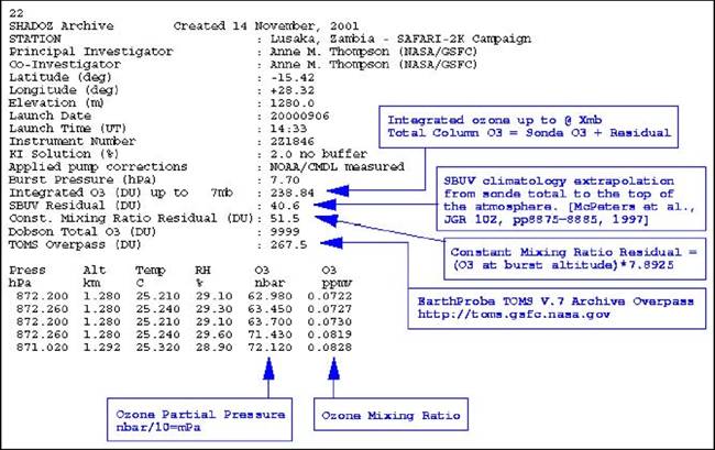
SAFARI 2000 SHADOZ Ozonesonde Data, Zambia and Regional Sites, Dry Season 2000 recent views
National Aeronautics and Space Administration —
Ozonesonde launches were made by the Southern Hemisphere ADditional OZonesondes (SHADOZ) group as part of the SAFARI 2000 Dry Season Campaign in September 2000... -
Federal
High Altitude MMIC Sounding Radiometer (HAMSR) CPEX-AW V1 recent views
National Aeronautics and Space Administration —
The High Altitude MMIC Sounding Radiometer (HAMSR) CPEX-AW dataset includes measurements gathered by the HAMSR instrument during the Convective Processes Experiment –... -
Federal
S-MODE Saildrone Level 1 Observations recent views
National Aeronautics and Space Administration —
This dataset contains a suite of Saildrone in-situ measurements (including but not limited to temperature, salinity, currents, biochemistry, and meteorology) taken... -
Federal
MLS/Aura Level 2 Diagnostics, Geophysical Parameter Grid V004 (ML2DGG) at GES DISC recent views
National Aeronautics and Space Administration —
ML2DGG is the EOS Aura Microwave Limb Sounder (MLS) product containing geophysical diagnostic quantities pertaining directly to the standard geophysical data... -
Federal
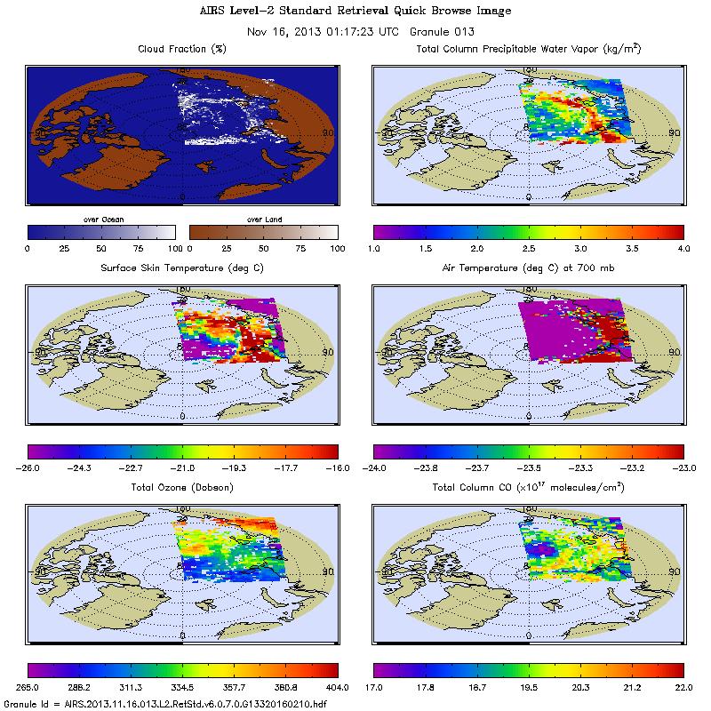
AIRS/Aqua L2 Standard Physical Retrieval (AIRS+AMSU) V006 (AIRX2RET) at GES DISC recent views
National Aeronautics and Space Administration —
The Atmospheric Infrared Sounder (AIRS) is a grating spectrometer (R = 1200) aboard the second Earth Observing System (EOS) polar-orbiting platform, EOS Aqua. In... -
Federal
SMMR/Nimbus-7 Color Images V001 (SMMRN7IM) at GES DISC recent views
National Aeronautics and Space Administration —
SMMRN7IM is the Nimbus-7 Scanning Multichannel Microwave Radiometer (SMMR) Color Image data product scanned from 17" x 15" color prints and saved as JPEG-2000 files.... -
Federal
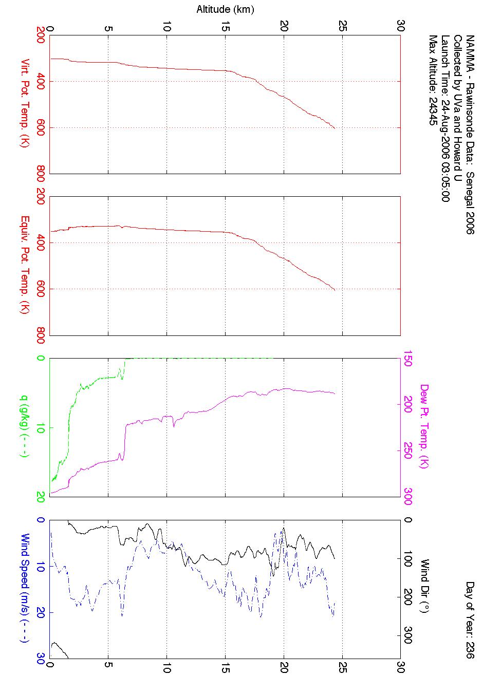
NAMMA SENEGAL RADIOSONDE AND TOWER FLUX DATA V1 recent views
National Aeronautics and Space Administration —
The NAMMA Senegal Radiosonde and Tower Flux data includes measurements of humidity, wind speed/direction and velocity. Additionally, the flux data includes... -
Federal
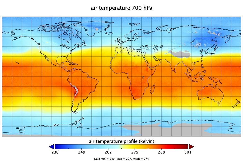
Sounder SIPS: Suomi NPP CrIMSS Level 3 Specific Quality Control Gridded Monthly SiFSAP V2 (SNDRSNIML3SMSFSP) at GES DISC recent views
National Aeronautics and Space Administration —
The SIFSAP (Single Field-of-View Sounder Atmospheric Products) algorithm provides retrieval for each sounder Field of View (FOV), therefore, it has 3-times higher... -
Federal
ECCO Ocean and Sea-Ice Surface Freshwater Fluxes - Daily Mean llc90 Grid (Version 4 Release 4) recent views
National Aeronautics and Space Administration —
This dataset provides daily-averaged ocean and sea-ice surface freshwater fluxes on the native Lat-Lon-Cap 90 (LLC90) model grid from the ECCO Version 4 Release 4... -
Federal
ATom: In-Situ Measurements of Airflow and Aerosols from Multiple Airborne Campaigns recent views
National Aeronautics and Space Administration —
This dataset provides results of selected in-situ measurements of airflow and aerosol particles collected during the following airborne campaigns: NASA Atmospheric... -
Federal
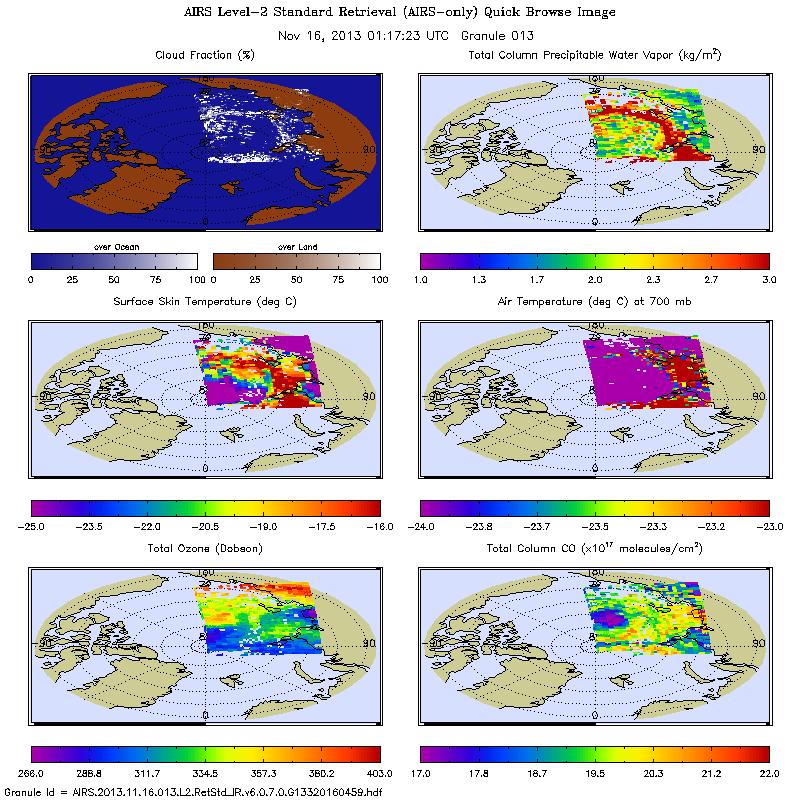
AIRS/Aqua L2 Near Real Time (NRT) Standard Physical Retrieval (AIRS-only) V006 (AIRS2RET_NRT) at GES DISC recent views
National Aeronautics and Space Administration —
The Atmospheric Infrared Sounder (AIRS) Level 2 Near Real Time (NRT) Standard Physical Retrieval (AIRS-only) product (AIRS2RET_NRT_006) differs from the routine... -
Federal
S-MODE L2 Shipboard Thermosalinograph, Meteorology, and Bio-optics Measurements Version 1 recent views
National Aeronautics and Space Administration —
This dataset contains shipboard thermosalinograph (TSG), meteorology, and bio-optics measurements taken during the Sub-Mesoscale Ocean Dynamics Experiment (S-MODE)... -
Federal
CAMEX-4 MIPS SURFACE STATION 2 V1 recent views
National Aeronautics and Space Administration —
The University of Alabama in Huntsville (UAH) Mobile Integrated Profiling System (MIPS) is a mobile atmospheric profiling system. It includes a 915 MHz Doppler... -
Federal
MLS/Aura Level 2 Diagnostics, Geophysical Parameter Grid V005 (ML2DGG) at GES DISC recent views
National Aeronautics and Space Administration —
ML2DGG is the EOS Aura Microwave Limb Sounder (MLS) product containing geophysical diagnostic quantities pertaining directly to the standard geophysical data... -
Federal
MetOp-A ASCAT ESDR Level 2 Modeled Ocean Surface Auxiliary Fields Version 1.0 recent views
National Aeronautics and Space Administration —
This dataset contains the first provisional release of the MEaSUREs-funded Earth Science Data Record (ESDR) of ancillary data corresponding to the MetOp-A ASCAT... -
Federal
ECCO Atmosphere Surface Temperature, Humidity, Wind, and Pressure - Daily Mean 0.5 Degree (Version 4 Release 4) recent views
National Aeronautics and Space Administration —
This dataset contains daily-averaged atmosphere surface temperature, humidity, wind, and pressure interpolated to a regular 0.5-degree grid from the ECCO Version 4... -
Federal
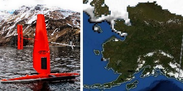
Saildrone 2021 Arctic field campaign for the Multi-Sensor Improved SST (MISST) project recent views
National Aeronautics and Space Administration —
Two Saildrone unmanned surface vehicles (USV) collected data on a 90-day cruise from Dutch Harbor Alaska to the Chukchi Sea and back, during 6 July 2021 to 20 October...

Official websites use .gov
A
.gov website belongs to an official government
organization in the United States.
Secure .gov websites use HTTPS
A
lock (
) or https:// means you’ve safely connected to
the .gov website. Share sensitive information only on official,
secure websites.