

AIRS/Aqua L2 Near Real Time (NRT) Standard Physical Retrieval (AIRS-only) V006 (AIRS2RET_NRT) at GES DISC
Access & Use Information
Public: This dataset is intended for public access and use.
License: No license information was provided. If this work was prepared by an officer or employee of the United States government as part of that person's official duties it is considered a U.S. Government Work.
Downloads & Resources
-
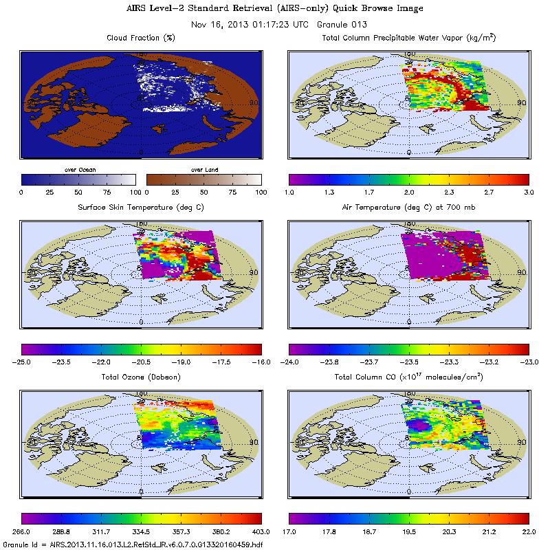
Get a related visualizationJPEG
AIRS2RET_NRT_006.jpeg
-
This dataset's landing pageHTML
Access the dataset landing page from the GES DISC website.
-
Download this dataset through a directory mapHTML
Access the data via HTTPS. User registration is required. Register for a...
-
Use OPeNDAP to access the dataset's dataHTML
Access the data via the OPeNDAP protocol.
-
Download this dataset through Earthdata SearchHTML
Use the Earthdata Search to find and retrieve data sets across multiple data...
-
The dataset's project home pageHTML
AIRS home page at NASA/JPL. General information on the AIRS...
-
View information related to this datasetHTML
AIRS Documentation Page
-
View this dataset's read me documentPDF
README Document
-
View documentation related to this datasetPDF
Memo on NRT vs Standard Product
-
View this dataset's algorithm theoretical...PDF
AIRS ATBD
-
Landing PageLanding Page
References
Dates
| Metadata Created Date | November 12, 2020 |
|---|---|
| Metadata Updated Date | April 11, 2025 |
Metadata Source
- Data.json Data.json Metadata
Harvested from NASA Data.json
Additional Metadata
| Resource Type | Dataset |
|---|---|
| Metadata Created Date | November 12, 2020 |
| Metadata Updated Date | April 11, 2025 |
| Publisher | NASA/GSFC/SED/ESD/GCDC/GESDISC |
| Maintainer | |
| Identifier | C1345119345-GES_DISC |
| Data First Published | 2024-07-03 |
| Language | en-US |
| Data Last Modified | 2025-03-31 |
| Category | Aqua, LANCE, geospatial |
| Public Access Level | public |
| Bureau Code | 026:00 |
| Metadata Context | https://project-open-data.cio.gov/v1.1/schema/catalog.jsonld |
| Schema Version | https://project-open-data.cio.gov/v1.1/schema |
| Catalog Describedby | https://project-open-data.cio.gov/v1.1/schema/catalog.json |
| Harvest Object Id | be85eab6-e55b-4fe6-8484-b205a12a4a62 |
| Harvest Source Id | 58f92550-7a01-4f00-b1b2-8dc953bd598f |
| Harvest Source Title | NASA Data.json |
| Homepage URL | https://cmr.earthdata.nasa.gov:443/search/concepts/C1345119345-GES_DISC.html |
| Metadata Type | geospatial |
| Old Spatial | -180.0 -90.0 180.0 90.0 |
| Program Code | 026:001 |
| Related Documents | https://doi.org/10.5194/acp-14-399-2014, https://doi.org/10.1117/1.JRS.8.084994, https://doi.org/10.1002/2014JD022551, https://doi.org/10.1002/2014JD02166, https://doi.org/10.1002/2016JD024806, https://doi.org/10.1002/2015JD024008, https://doi.org/10.1029/2005/JD007020, https://doi.org/10.1109/TGRS.2002.808236 |
| Source Datajson Identifier | True |
| Source Hash | 92814ca2085adad788beaf5e6061658d16e224c77900250bd30f2a64ce7c91e6 |
| Source Schema Version | 1.1 |
| Spatial | |
| Temporal | 2016-10-15T00:00:00Z/2024-08-12T00:00:00Z |
Didn't find what you're looking for? Suggest a dataset here.