
-
Federal
NNDSS - TABLE 1OO. Viral hemorrhagic fevers, Machupo virus to Viral hemorrhagic fevers, Sabia virus
U.S. Department of Health & Human Services —
NNDSS - TABLE 1OO. Viral hemorrhagic fevers, Machupo virus to Viral hemorrhagic fevers, Sabia virus - 2019. In this Table, provisional cases* of notifiable diseases... -
Federal
Synthesize Data for Emerging Data Cleaning and Fusion Tool Inventory
Department of Transportation —
The Synthesize Data for Emerging Data Cleaning and Fusion Tool dataset is a privacy-preserving synthetic dataset developed to support and demonstrate the... -
Federal
NOAA/WDS Paleoclimatology - Northern Hemisphere Extratropical 1000 Year Temperature Reconstruction
National Oceanic and Atmospheric Administration, Department of Commerce —
This archived Paleoclimatology Study is available from the NOAA National Centers for Environmental Information (NCEI), under the World Data Service (WDS) for... -
Federal
CRED Subsurface Temperature Recorder (STR); MHI, LAN; Long: -156.83701, Lat: 20.87187 (WGS84); Sensor Depth: 13.10m; Data Range: 20060805-20081019.
National Oceanic and Atmospheric Administration, Department of Commerce —
Data from Coral Reef Ecosystem Division (CRED), NOAA Pacific Islands Fisheries Science Center (PIFSC) Subsurface Temperature Recorders (STR) provide a time series of... -
Federal
Walton-Smith CTD, WS0718, WS0718_WS0718_049, 2007-07-12, 25.583N 81.2905W
National Oceanic and Atmospheric Administration, Department of Commerce —
Walton-Smith Conductivity, Temperature, Depth (CTD) - WS0718 - WS0718_WS0718_049 - 2007-07-12 - 25.583N 81.2905W. Hydrographic Measurements in the Gulf of Mexico.... -
Trail Mile Markers
District of Columbia —
The Trail Mile Marker dataset includes mile marker locations on the sections of the Anacostia River Trail, Metropolitan Branch Trail, and Klingle Valley Trail. The... -
Federal
NOAA/WDS Paleoclimatology - Guatemala 300 Year Documentary Hydrological Records
National Oceanic and Atmospheric Administration, Department of Commerce —
This archived Paleoclimatology Study is available from the NOAA National Centers for Environmental Information (NCEI), under the World Data Service (WDS) for... -
Federal
TIGER/Line Shapefile, 2021, County, St. Clair County, MI, All Roads
U.S. Census Bureau, Department of Commerce —
The TIGER/Line shapefiles and related database files (.dbf) are an extract of selected geographic and cartographic information from the U.S. Census Bureau's Master... -
Federal
ROSETTA-ORBITER 67P SREM 5 ESCORT 1 MTP013 V1.0
National Aeronautics and Space Administration —
This data set contains derived electron and proton flux energies in MeV from the Standard Radiation Environment Monitor (SREM) instrument on the Rosetta spacecraft,... -
Federal
Gulf of Alaska Line-Transect Survey (GOALS) II: Marine Mammal Occurrence in the Temporary Maritime Activities Area (TMAA) 2013 Raw Sonobuoy Data
National Oceanic and Atmospheric Administration, Department of Commerce —
The U.S. Navy periodically uses a Temporary Maritime Activities Area (TMAA) in the central Gulf of Alaska (GoA), east of Kodiak Island. Current scientific data on... -
Federal
Global Navigation Satellite System (GNSS) IGS Ionosphere Vertical Total Electron Content (VTEC) Final Product from NASA CDDIS
National Aeronautics and Space Administration —
This derived product set consists of Global Navigation Satellite System Final Ionosphere Vertical Total Electron Content (VTEC) product (daily files) from the NASA... -
Federal
SOUTH AFRICAN ASTRON. OBS. IMAGE DATA FROM SL9 IMPACTS
National Aeronautics and Space Administration —
TBD -
Federal
VG2 SAT CRS RESAMPLED SUMMARY D1 RATE ELEC 192SEC V1.0
National Aeronautics and Space Administration —
not applicable -
Federal
W00438: NOS Hydrographic Survey , External Source Data 2018, 2017-10-09
National Oceanic and Atmospheric Administration, Department of Commerce —
The National Oceanic and Atmospheric Administration (NOAA) has the statutory mandate to collect hydrographic data in support of nautical chart compilation for safe... -
Federal
TIGER/Line Shapefile, 2023, County, Maunabo Municipio, PR, Linear Hydrography
U.S. Census Bureau, Department of Commerce —
The TIGER/Line shapefiles and related database files (.dbf) are an extract of selected geographic and cartographic information from the U.S. Census Bureau's Master... -
Federal
ROSETTA-ORBITER 67P ROSINA 3 EXT1 V2.0
National Aeronautics and Space Administration —
This data set contains CODMAC level 3 science data acquired by the DFMS and RTOF ROSINA sensors between 2016-01-13 and 2016-04-05 during the Extension phase 1 of the... -
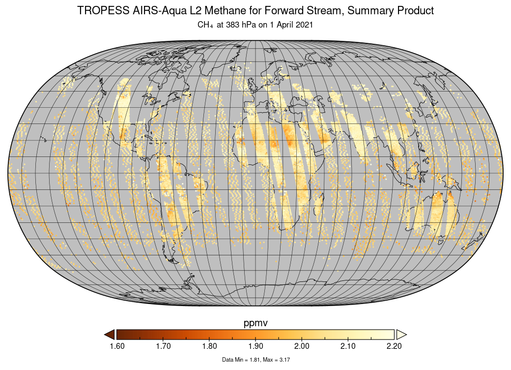
Federal
TROPESS AIRS-Aqua L2 Methane for Forward Stream, Summary Product V1 (TRPSYL2CH4AIRSFS) at GES DISC
National Aeronautics and Space Administration —
The TROPESS AIRS-Aqua L2 Methane for Forward Stream, Summary Product contains the vertical distribution of the retrieved atmospheric state of methane (CH4), and... -
State
ICRC Average Processing Time by Month
State of Iowa —
This measure averages the processing time (in days) for discrimination cases processed and closed by the Iowa Civil Rights Commission in Iowa each month. -
Federal
MODIS/Terra+Aqua BRDF Model Parameters Daily L3 Global 1km SIN Grid V061
National Aeronautics and Space Administration —
The MCD19A3D Version 6.1 data product is a Moderate Resolution Imaging Spectroradiometer (MODIS) Terra and Aqua combined Bidirectional Reflectance Distribution... -
State
Purchase Card (PCard) Fiscal Year 2015
State of Oklahoma —
This dataset contains information on purchases made through the purchase card programs administered by the state and higher ed institutions. The purchase card...

Official websites use .gov
A
.gov website belongs to an official government
organization in the United States.
Secure .gov websites use HTTPS
A
lock (
) or https:// means you’ve safely connected to
the .gov website. Share sensitive information only on official,
secure websites.