
-
Federal
Interpolated groundwater levels and altitudes for Monroe County, West Virginia, 2017-2019
Department of the Interior —
These interpolated groundwater levels and altitudes product, for Monroe County, WV, was derived from groundwater-level data obtained from a U.S. Geological Survey... -
Federal
TIGER/Line Shapefile, 2024, State, Louisiana, Area Landmark
U.S. Census Bureau, Department of Commerce —
The TIGER/Line shapefiles and related database files (.dbf) are an extract of selected geographic and cartographic information from the U.S. Census Bureau's Master... -
University
DISABILITY Percent Civilian Noninstitutional Males by Age CTs 2000
Earth Data Analysis Center, University of New Mexico —
TIGER, TIGER/Line, and Census TIGER are registered trademarks of the Bureau of the Census. The Redistricting Census 2000 TIGER/Line files are an extract of selected... -
Federal
H03826: NOS Hydrographic Survey
National Oceanic and Atmospheric Administration, Department of Commerce —
The National Oceanic and Atmospheric Administration (NOAA) has the statutory mandate to collect hydrographic data in support of nautical chart compilation for safe... -
Federal
TIGER/Line Shapefile, 2024, County, Caribou County, ID, Linear Hydrography
U.S. Census Bureau, Department of Commerce —
The TIGER/Line shapefiles and related database files (.dbf) are an extract of selected geographic and cartographic information from the U.S. Census Bureau's Master... -
City
2021 - 2022 Average Class Size by Borough
City of New York —
Class Size Borough report for middle and high school grades by program type, number of students, number of classes, and average class size. -
Federal
L01274: NOS Hydrographic Survey
National Oceanic and Atmospheric Administration, Department of Commerce —
The National Oceanic and Atmospheric Administration (NOAA) has the statutory mandate to collect hydrographic data in support of nautical chart compilation for safe... -
Federal
CRED Subsurface Temperature Recorder (STR); NWHI, PHR; Long: -175.89442, Lat: 27.91187 (WGS84); Sensor Depth: 2.74m; Data Range: 20080924-20100916.
National Oceanic and Atmospheric Administration, Department of Commerce —
Data from Coral Reef Ecosystem Division (CRED), NOAA Pacific Islands Fisheries Science Center (PIFSC) Subsurface Temperature Recorders (STR) provide a time series of... -
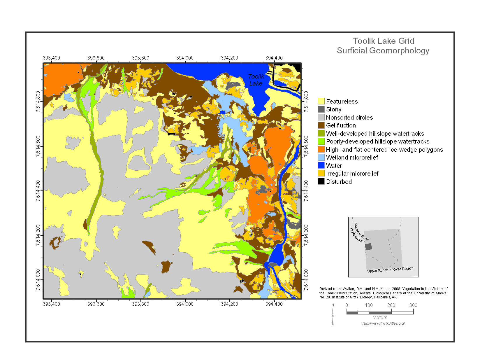
Federal
Maps of Vegetation Types and Physiographic Features, Toolik Lake Area, Alaska
National Aeronautics and Space Administration —
This data set provides the spatial distributions of vegetation types, soil carbon, and physiographic features in the Toolik Lake area, Alaska. Specific attributes... -
Federal
Mineral Commodity Summaries 2023 - IODINE Data Release
Department of the Interior —
This data release contains the U.S. salient statistics and world production data extracted from the IODINE data sheet of the USGS Mineral Commodity Summaries 2023. -
Federal
Southern California Shelf Rockfish Hook and Line Survey (station)
National Oceanic and Atmospheric Administration, Department of Commerce —
This layer is intended to represent the geographic extent of NOAA Fisheriesâ Southern California Shelf Rockfish Hook and Line Survey. The Southern California Shelf... -
Federal
TIGER/Line Shapefile, 2024, County, Ingham County, MI, Address Range-Feature
U.S. Census Bureau, Department of Commerce —
The TIGER/Line shapefiles and related database files (.dbf) are an extract of selected geographic and cartographic information from the U.S. Census Bureau's Master... -
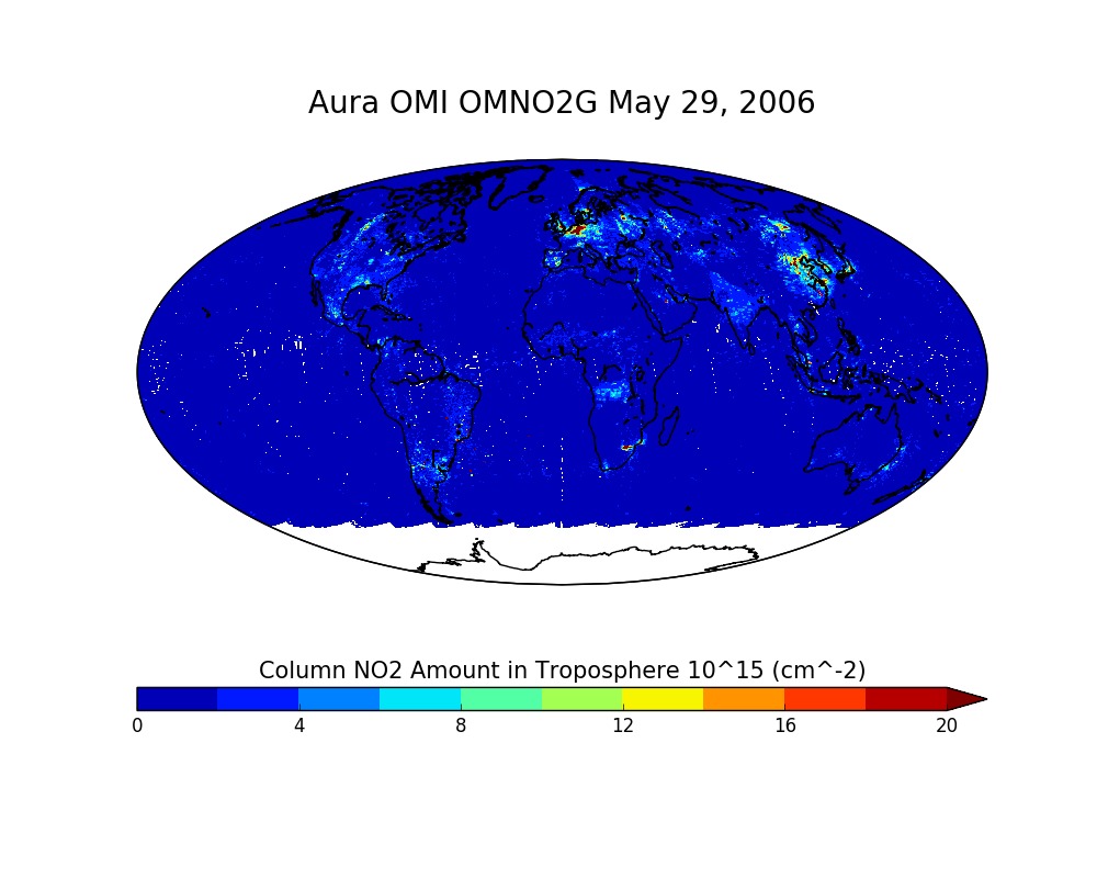
Federal
OMI/Aura NO2 Total and Tropospheric Column Daily L2 Global Gridded 0.25 degree x 0.25 degree V3 (OMNO2G) at GES DISC
National Aeronautics and Space Administration —
This Level-2G daily global gridded product OMNO2G is based on the pixel level OMI Level-2 NO2 product OMNO2. OMNO2G data product is a special Level-2 Gridded Product... -
Federal
FSBBAYA Array, Station AISLE 9, Bottom Temperature
National Oceanic and Atmospheric Administration, Department of Commerce —
Timeseries data from 'FSBBAYA Array, Station AISLE 9, Bottom Temperature' (org_secoora_fsbbaya_aisle_9) -
Federal
Scorecard filters v2.12.4 (cmsdev)
U.S. Department of Health & Human Services —
This is a dataset created for the Medicaid Scorecard website (https://www.medicaid.gov/state-overviews/scorecard/index.html), and is not intended for use outside that... -
Federal
TIGER/Line Shapefile, 2023, County, Ogle County, IL, All Roads
U.S. Census Bureau, Department of Commerce —
The TIGER/Line shapefiles and related database files (.dbf) are an extract of selected geographic and cartographic information from the U.S. Census Bureau's Master... -
Federal
ASD FieldSpecⓇ NG calibration data - collected at Cripple Creek Victor mine, Cripple Creek, Colorado, 2017
Department of the Interior —
HySpex by NEO VNIR-1800 and SWIR-384 imaging spectrometer radiance data were acquired on September 14, 2017 at the Cresson Pit of the Cripple Creek & Victor mine... -
Federal
Early Estimates of Exotic Annual Grass (EAG) in the Sagebrush Biome, USA, 2022, May 18th, 2022
Department of the Interior —
These datasets provide early estimates of 2022 fractional cover for exotic annual grass (EAG) species and one native perennial grass species on a bi-weekly basis from... -
Federal
TIGER/Line Shapefile, 2022, County, Wood County, TX, Address Ranges Relationship File
U.S. Census Bureau, Department of Commerce —
The TIGER/Line shapefiles and related database files (.dbf) are an extract of selected geographic and cartographic information from the U.S. Census Bureau's Master... -
Federal
Fishery-Independent Turtle Excluder Device Catch Assessment Data: Skimmer Trawl Fishery
National Oceanic and Atmospheric Administration, Department of Commerce —
Skimmer trawls are utilized throughout the southeastern United States to target penaeid shrimp (Penaeidae). Because the codends of these trawls can be readily...

Official websites use .gov
A
.gov website belongs to an official government
organization in the United States.
Secure .gov websites use HTTPS
A
lock (
) or https:// means you’ve safely connected to
the .gov website. Share sensitive information only on official,
secure websites.