

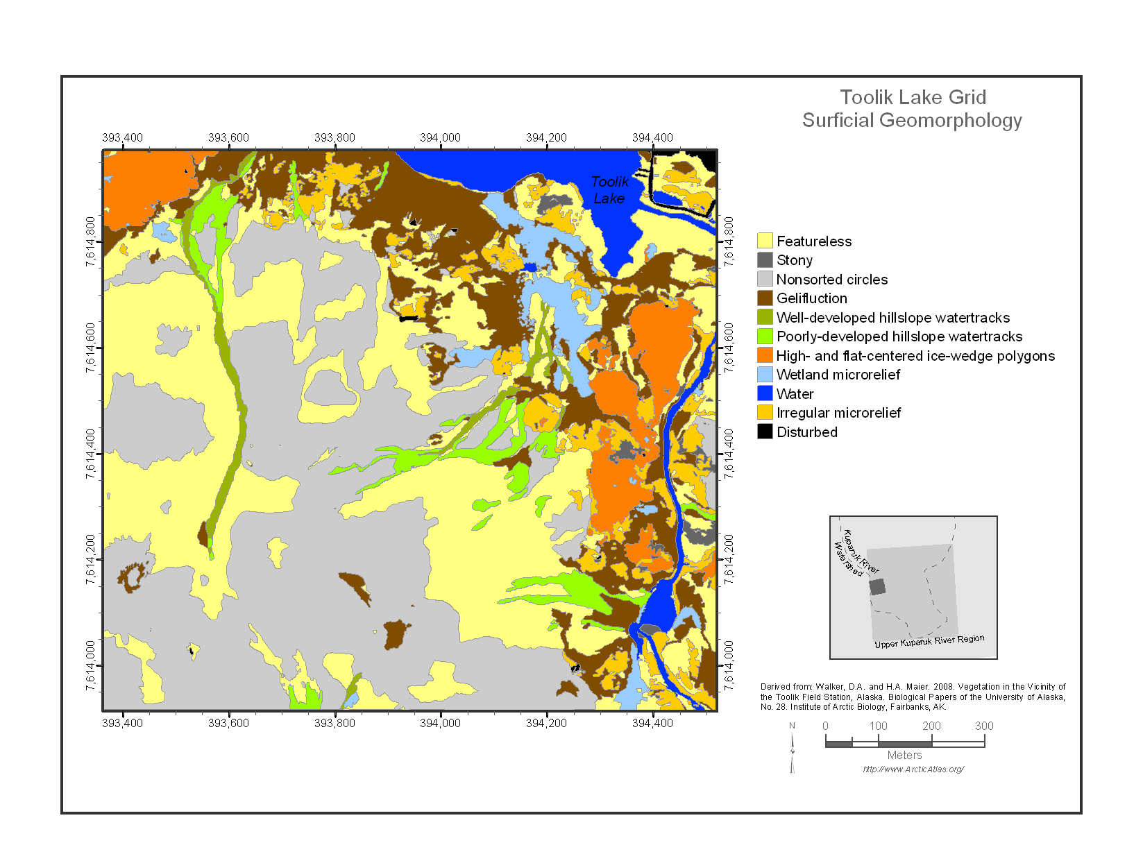
Maps of Vegetation Types and Physiographic Features, Toolik Lake Area, Alaska
Access & Use Information
Public: This dataset is intended for public access and use.
License: No license information was provided. If this work was prepared by an officer or employee of the United States government as part of that person's official duties it is considered a U.S. Government Work.
Downloads & Resources
-
Data Information (Unknown Format)BIN
-
Data Information (HTML)HTML
-
Data Information (ZIP)ZIP
Toolik_Lake_Area_Veg_Maps_1380.zip
-
Data Information (PNG)PNG
Toolik_Lake_Area_Veg_Maps_Fig1.png
-
Data Information (Unknown Format)BIN
-
Data Information (PDF)PDF
Toolik_Lake_Area_Veg_Maps.pdf
-
Data Information (Unknown Format)BIN
aga_toolik_area_geobotanical_walker_2008.kmz
-
Data Information (Unknown Format)BIN
aga_toolik_area_veg_plot_washers_buchhorn_2014.kmz
-
Data Information (Unknown Format)BIN
aga_toolik_grid_geobotanical_walker_2008.kmz
-
Data Information (Unknown Format)BIN
aga_toolik_grid_points_buchhorn_2014.kmz
-
Landing PageLanding Page
Dates
| Metadata Created Date | April 11, 2025 |
|---|---|
| Metadata Updated Date | September 19, 2025 |
Metadata Source
- Data.json Data.json Metadata
Harvested from NASA Data.json
Additional Metadata
| Resource Type | Dataset |
|---|---|
| Metadata Created Date | April 11, 2025 |
| Metadata Updated Date | September 19, 2025 |
| Publisher | ORNL_DAAC |
| Maintainer | |
| Identifier | 10.3334/ORNLDAAC/1380 |
| Data Last Modified | 2025-09-11 |
| Category | Earth Science |
| Public Access Level | public |
| Bureau Code | 026:00 |
| Metadata Context | https://project-open-data.cio.gov/v1.1/schema/catalog.jsonld |
| Schema Version | https://project-open-data.cio.gov/v1.1/schema |
| Catalog Describedby | https://project-open-data.cio.gov/v1.1/schema/catalog.json |
| Harvest Object Id | fb175d86-7393-44db-96c9-c77b93bc4f74 |
| Harvest Source Id | 58f92550-7a01-4f00-b1b2-8dc953bd598f |
| Harvest Source Title | NASA Data.json |
| Homepage URL | https://search.earthdata.nasa.gov/search?q=Toolik_Lake_Area_Veg_Maps_1380&ac=true |
| Old Spatial | {"WestBoundingCoordinate":-149.67,"NorthBoundingCoordinate":68.6561,"EastBoundingCoordinate":-149.546,"SouthBoundingCoordinate":68.6169},"CARTESIAN" |
| Program Code | 026:000 |
| Source Datajson Identifier | True |
| Source Hash | a278cd7edf98fc9ab43fd4d09848783c7fced2bfd5deb3c5516f1225b4b27598 |
| Source Schema Version | 1.1 |
| Spatial | |
| Temporal | 1990-01-01/1990-01-01 |
Didn't find what you're looking for? Suggest a dataset here.