
-
Federal
MKAD (Open Sourced Code)
National Aeronautics and Space Administration —
The Multiple Kernel Anomaly Detection (MKAD) algorithm is designed for anomaly detection over a set of files. It combines multiple kernels into a single optimization... -
Federal
RSW hexahedral grids
National Aeronautics and Space Administration —
RSW hexahedral grids in CGNS (unstructured) and Plot3d (structured) formats generated by ANSYS Germany. Please see AePW_RSW_Grids.pptx below for full description of... -
Federal
BSCW Unstructured Grids - VGRID software
National Aeronautics and Space Administration —
These grids were constructed using VGRID software from NASA Langley. The grids designed for node based (labeled 'nc') and cell-centered solvers are supplied. Grids... -
Federal
HIRENASD Unstructured Grids - VGRID software FINAL
National Aeronautics and Space Administration —
These grids were constructed using VGRID software from NASA Langley. The grids designed for node based (labeled 'nc') and cell-centered (labeled 'cc') solvers are... -
Federal
HIRENASD Unstructured Grids - VGRID software
National Aeronautics and Space Administration —
These grids were constructed using VGRID software from NASA Langley. The grids designed for node based (labeled 'nc') and cell-centered solvers are supplied. Grids... -
Federal
BUV/Nimbus-4 Level 1 Radiance and Housekeeping Data in Telemetry Units V001 (BUVN4L1PDB) at GES DISC
National Aeronautics and Space Administration —
The Nimbus-4 BUV Level-1 Radiance and Housekeeping Data in Telemetry Units collection contains the raw counts measured by the Backscatter Ultraviolet Spectrometer... -
Federal
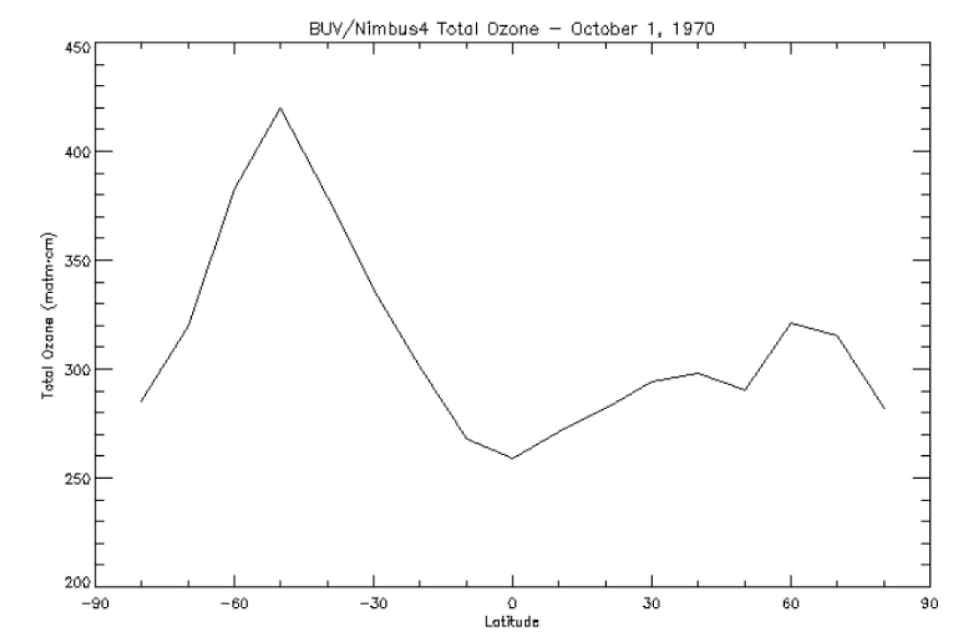
BUV/Nimbus-4 Level 3 Ozone Zonal Means V005 (BUVN4L3ZMT) at GES DISC
National Aeronautics and Space Administration —
The Nimbus-4 BUV Level 3 Ozone Zonal Means collection or ZMT contains total ozone, reflectivities, and ozone mixing ratios averaged in 10 degree latitude zones... -
Federal
BSCW Unstructured Grids - VGRID software FINAL
National Aeronautics and Space Administration —
These grids were constructed using VGRID software from NASA Langley. The grids designed for node based (labeled 'nc') and cell-centered solvers are supplied. Grids... -
Federal
BUV/Nimbus-4 Level 2 Compressed Ozone Profile Data V005 (BUVN4L2CPOZ) at GES DISC
National Aeronautics and Space Administration —
The Nimbus-4 BUV Level 2 Compressed Ozone Profile Data collection or CPOZ contains total ozone, reflectivities, ozone mixing ratios and layer ozone amounts measured... -
Federal
BUV/Nimbus-4 Level 1 Radiance Data V001 (BUVN4L1RUT) at GES DISC
National Aeronautics and Space Administration —
The Nimbus-4 BUV Level-1 Radiance data collection was derived from the Primary Data Base (PDB) product and contains the calibrated and geolocated backscattered... -
Federal
BUV/Nimbus-4 Dark Current Study Master Data V001 (BUVN4L1DCM) at GES DISC
National Aeronautics and Space Administration —
The Nimbus-4 BUV Level-1 Dark Current Study Master Data is derived from the BUV Level 1 Radiance (RUT) product and contains the geophysical indices and... -
Federal
ESMR/Nimbus-5 Images of Brightness Temperature on 70 mm Film V001 (ESMRN5IM) at GES DISC
National Aeronautics and Space Administration —
ESMRN5IM is the Nimbus-5 Electrically Scanning Microwave Radiometer (ESMR) data product containing daily brightness temperature images from 70-mm photofacsimile film... -
Federal
HRIR/Nimbus-2 Level 1 Meteorological Radiation Data V001 (HRIRN2L1) at GES DISC
National Aeronautics and Space Administration —
HRIRN2L1 is the High Resolution Infrared Radiometer (HRIR) Nimbus-2 Level 1 Meteorological Radiance Data (NMRT) product and contains infrared radiances converted to... -
Federal
LRIR/Nimbus-6 Level 2 Inverted Profiles of Temperature and Ozone V001 (LRIRN6L2IPAT) at GES DISC
National Aeronautics and Space Administration —
LRIRN6L2IPAT is the Nimbus-6 Limb Radiance Inversion Radiometer (LRIR) Level 2 Inverted Profiles of Temperature and Ozone data product. The product contains daily... -
Federal
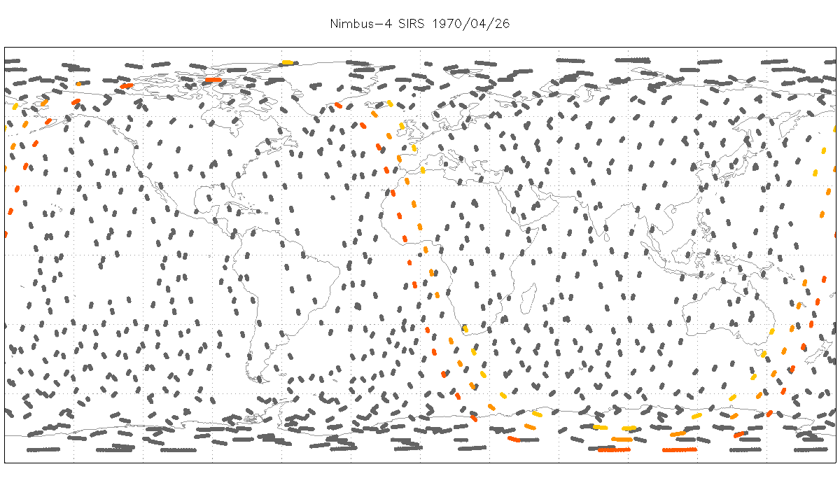
SIRS/Nimbus-4 Level 1 Radiance Data V001 (SIRSN4L1) at GES DISC
National Aeronautics and Space Administration —
SIRSN4L1 is the Nimbus-4 Satellite Infrared Spectrometer (SIRS) Level 1 Radiance Data product. SIRS measured infrared radiation (11 to 36 micrometers) emitted from... -
Federal
SIRS/Nimbus-3 Level 1 Radiance Data V001 (SIRSN3L1) at GES DISC
National Aeronautics and Space Administration —
SIRSN3L1 is the Nimbus-3 Satellite Infrared Spectrometer (SIRS) Level 1 Radiance Data product. SIRS measured infrared radiation (11 to 36 micrometers) emitted from...

Official websites use .gov
A
.gov website belongs to an official government
organization in the United States.
Secure .gov websites use HTTPS
A
lock (
) or https:// means you’ve safely connected to
the .gov website. Share sensitive information only on official,
secure websites.