
-
Federal
CAMEX-3 DC-8 NAVIGATION (DADS) DATA V1
National Aeronautics and Space Administration —
The CAMEX-3 DC-8 Navigation Data Acquisition and Distribution System (DADS) data files contain information recorded by navigation and data collection systems onboard... -
Federal
CAMEX-3 LiDAR Atmospheric Sensing Experiment (LASE) Imagery V1
National Aeronautics and Space Administration —
The CAMEX-3 LiDAR Atmospheric Sensing Experiment (LASE) Imagery dataset is a browse-only dataset that consists of plotted reflectivity data collected by the LiDAR... -
Federal
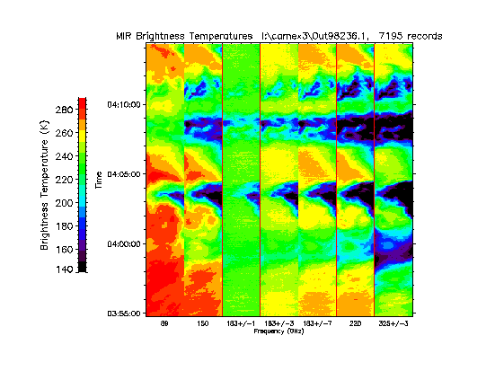
CAMEX-3 ER-2 Millimeter-wave Imaging Radiometer (MIR) V1
National Aeronautics and Space Administration —
The CAMEX-3 ER-2 Millimeter-wave Imaging Radiometer (MIR) dataset is a browse-only dataset containing plots of brightness temperature measurements collected by the... -
Federal
USGS Group on Earth Observations (GEO) Global Agricultural Monitoring (GLAM) Russia
National Aeronautics and Space Administration —
The objective of GEO is to fulfil a vision of a world where decisions and actions are informed by coordinated, comprehensive and sustained Earth Observation (EO).... -
Federal
USGS Group on Earth Observations (GEO) Global Agricultural Monitoring (GLAM) Ethiopia
National Aeronautics and Space Administration —
The objective of GEO is to fulfil a vision of a world where decisions and actions are informed by coordinated, comprehensive and sustained Earth Observation (EO).... -
Federal
High-Resolution Radar Imagery, Digital Elevation Models, and Related GIS Layers for Barrow, Alaska, USA, Version 1
National Aeronautics and Space Administration —
This product set contains high-resolution Interferometric Synthetic Aperture Radar (IFSAR) imagery and geospatial data for the Barrow Peninsula (155.39 - 157.48 deg... -
Federal
USGS Group on Earth Observations (GEO) Global Agricultural Monitoring (GLAM) Australia
National Aeronautics and Space Administration —
The objective of GEO is to fulfil a vision of a world where decisions and actions are informed by coordinated, comprehensive and sustained Earth Observation (EO).... -
Federal
USGS Group on Earth Observations (GEO) Global Agricultural Monitoring (GLAM) Algeria
National Aeronautics and Space Administration —
The objective of GEO is to fulfil a vision of a world where decisions and actions are informed by coordinated, comprehensive and sustained Earth Observation (EO).... -
Federal
SASS (Subsonics Assessment) Ozone and NOx Experiment (SONEX) DC-8 In-Situ Meteorological and Navigation Data
National Aeronautics and Space Administration —
SONEX_TraceGas_AircraftInSitu_DC8_Data_1 is the in-situ meteorological and navigation data collected onboard the DC-8 aircraft during the SASS (Subsonics Assessment)... -
Federal
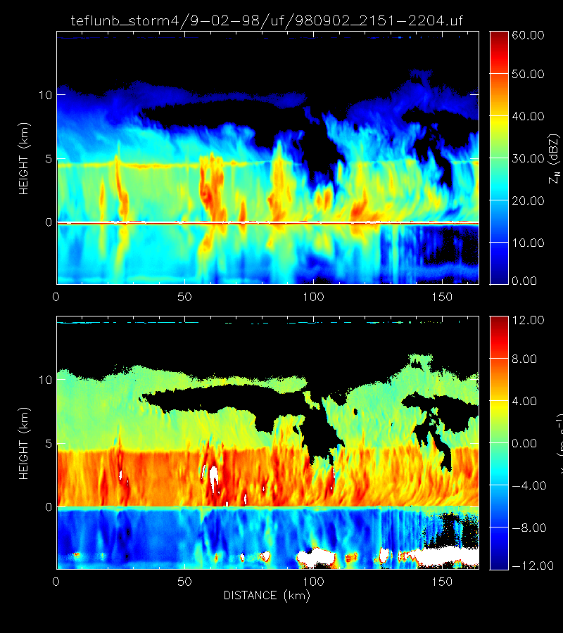
CAMEX-3 ER-2 Doppler Radar (EDOP) V1
National Aeronautics and Space Administration —
The CAMEX-3 ER-2 Doppler Radar (EDOP) dataset is a browse-only dataset that consists of plotted reflectivity and Doppler velocity data collected by the ER-2 Doppler... -
Federal
USGS Group on Earth Observations (GEO) Global Agricultural Monitoring (GLAM) Uganda
National Aeronautics and Space Administration —
The objective of GEO is to fulfil a vision of a world where decisions and actions are informed by coordinated, comprehensive and sustained Earth Observation (EO).... -
Federal
Reduced-Resolution Radar Imagery, Digital Elevation Models, and Related GIS Layers for Barrow, Alaska, USA, Version 1
National Aeronautics and Space Administration —
This product set contains reduced-resolution Interferometric Synthetic Aperture Radar (IFSAR) imagery and geospatial data for the Barrow Peninsula (155.39 - 157.48... -
Federal
USGS Group on Earth Observations (GEO) Global Agricultural Monitoring (GLAM) Ukraine
National Aeronautics and Space Administration —
The objective of GEO is to fulfill a vision of a world where decisions and actions are informed by coordinated, comprehensive and sustained Earth Observation (EO).... -
Federal
USGS Group on Earth Observations (GEO) Global Agricultural Monitoring (GLAM) Pakistan
National Aeronautics and Space Administration —
The objective of GEO is to fulfil a vision of a world where decisions and actions are informed by coordinated, comprehensive and sustained Earth Observation (EO).... -
Federal
USGS Group on Earth Observations (GEO) Global Agricultural Monitoring (GLAM) Argentina
National Aeronautics and Space Administration —
The objective of GEO is to fulfil a vision of a world where decisions and actions are informed by coordinated, comprehensive and sustained Earth Observation (EO).... -
Federal
UARS PEM Level 2 VMAG DC V001 (UARPE2VMAGDC) at GES DISC
National Aeronautics and Space Administration —
The Particle Environment Monitor (PEM) level 2 Vector Magnetometer (VMAG) DC daily product contains the Vector Magnetic Field component, UARS Aspect Magnetometers...

Official websites use .gov
A
.gov website belongs to an official government
organization in the United States.
Secure .gov websites use HTTPS
A
lock (
) or https:// means you’ve safely connected to
the .gov website. Share sensitive information only on official,
secure websites.