
-
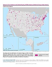
ATSDR Hazardous Waste Site Polygon Data, Version 2 recent views
The Agency for Toxic Substances and Disease Registry (ATSDR) Hazardous Waste Site Polygon Data, Version 2 consists of 2,080 polygons for selected hazardous waste sites that were... -
Methane Plumes Derived from AVIRIS-NG over Point Sources across California, 2016-2017 recent views
This dataset provides maps of methane (CH4) plumes along flight lines over identified methane point-source emitting infrastructure across the State of California, USA collected... -
Effects of Climate Change on Global Food Production from SRES Emissions and Socioeconomic Scenarios recent views
The Effects of Climate Change on Global Food Production from SRES Emissions and Socioeconomic Scenarios is an update to a major crop modeling study by the NASA Goddard Institute... -
Global Estimated Net Migration Grids by Decade: 1970-2000 recent views
The Global Estimated Net Migration by Decade: 1970-2000 data set provides estimates of net migration over the three decades from 1970 to 2000. Because of the lack of globally... -
Annual Land Use and Urban Land Cover: Ethiopia, Nigeria, and South Africa, 2016-2020 recent views
This dataset provides a two-tier annual Land Use (LU) and Urban Land Cover (LC) product suite over three African countries, Ethiopia, Nigeria, and South Africa, across a 5-year... -
Archive of Census Related Products (ACRP): 1980 SAS Transport Files recent views
The 1980 SAS Transport Files portion of the Archive of Census Related Products (ACRP) contains housing and population demographics from the 1980 Summary Tape File (STF3A)... -
Dar es Salaam Land Use and Informal Settlement Data Set recent views
The Dar es Salaam Land Use and Informal Settlement Data Set represents urban land use and consolidation of informal settlements for the years 1982, 1992, 1998, and 2002, in Dar... -
Gridded Population of the World, Version 3 (GPWv3): Population Density Grid, Future Estimates recent views
The Gridded Population of the World, Version 3 (GPWv3): Population Density Grid, Future EstimatesFuture Estimates consists of estimates of human population for the years 2005,... -
IPCC Fourth Assessment Report (AR4) Observed Climate Change Impacts Database recent views
The Intergovernmental Panel on Climate Change (IPCC) Fourth Assessment Report (AR4) Observed Climate Change Impacts Database contains observed responses to climate change across... -
Global Rural-Urban Mapping Project, Version 1 (GRUMPv1): National Identifier Grid recent views
The Global Rural-Urban Mapping Project, Version 1 (GRUMPv1): National Identifier Grid is derived from the land area grid to create a raster surface where pixels (cells) that... -
NACP: Urban Greenhouse Gases across the CO2 Urban Synthesis and Analysis Network, V2 recent views
This dataset provides hourly urban greenhouse gas measurements for cities in the CO2 Urban Synthesis and Analysis (CO2-USA) Data Synthesis Network for 2000 to 2019. Measurements... -
CODATA Catalog of Roads Data Sets, Version 1 recent views
The CODATA Catalog of Roads Data Sets, Version 1 contains 367 entries describing national-level road network data sets for 147 countries and four entries describing global data...

Official websites use .gov
A
.gov website belongs to an official government
organization in the United States.
Secure .gov websites use HTTPS
A
lock (
) or https:// means you’ve safely connected to
the .gov website. Share sensitive information only on official,
secure websites.