Methane Plumes Derived from AVIRIS-NG over Point Sources across California, 2016-2017
Access & Use Information
Downloads & Resources
-
Google Scholar search resultsHTML
Search results for publications that cite this dataset by its DOI.
-
Download this datasetHTML
This link allows direct data access via Earthdata login
-
View documentation related to this datasetHTML
ORNL DAAC Data Set Documentation
-
This dataset's landing pageHTML
Data set Landing Page DOI URL
-
View documentation related to this datasetPDF
California Methane Survey: quantitative plume image data: CH4_Plume_AVIRIS-...
-
Get a related visualizationJPEG
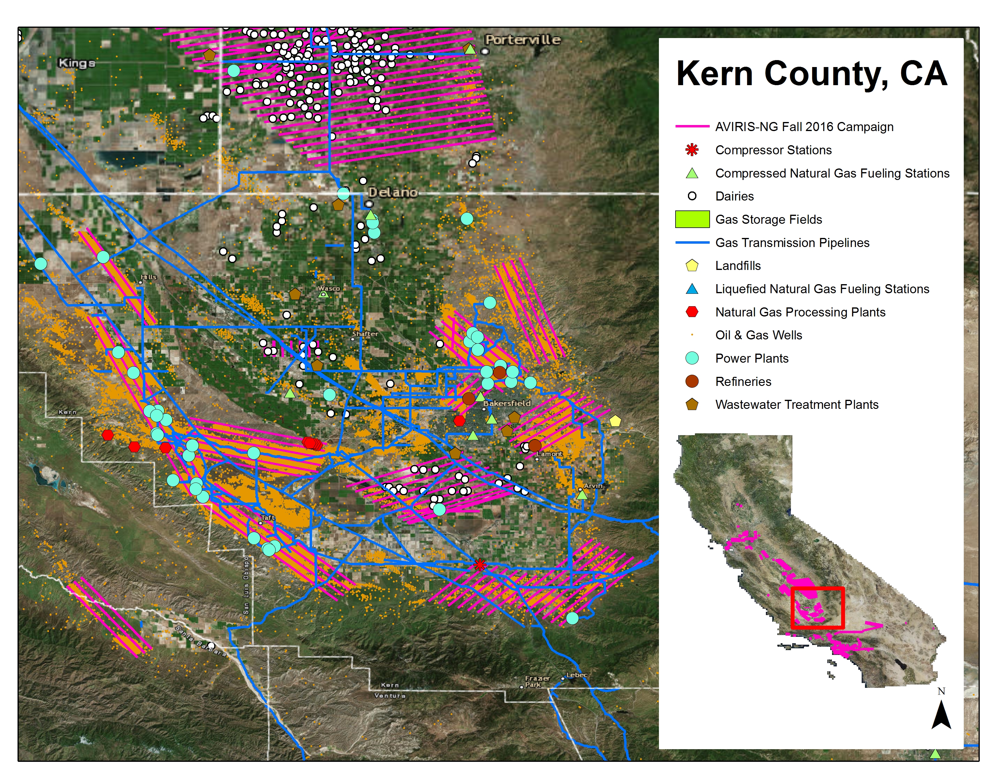
Example of AVIRIS-NG flight lines over the southern San Joaquin Valley, Kern...
-
Use Web Coverage Service (WCS) to download the...HTML
Web Coverage Service for this collection.
-
Landing PageLanding Page
Dates
| Metadata Created Date | December 1, 2022 |
|---|---|
| Metadata Updated Date | December 6, 2023 |
Metadata Source
- Data.json Data.json Metadata
Harvested from NASA Data.json
Graphic Preview

Additional Metadata
| Resource Type | Dataset |
|---|---|
| Metadata Created Date | December 1, 2022 |
| Metadata Updated Date | December 6, 2023 |
| Publisher | ORNL_DAAC |
| Maintainer | |
| Identifier | C2389764676-ORNL_CLOUD |
| Data First Published | 2019-11-12 |
| Language | en-US |
| Data Last Modified | 2023-06-12 |
| Category | CMS, geospatial |
| Public Access Level | public |
| Bureau Code | 026:00 |
| Metadata Context | https://project-open-data.cio.gov/v1.1/schema/catalog.jsonld |
| Metadata Catalog ID | https://data.nasa.gov/data.json |
| Schema Version | https://project-open-data.cio.gov/v1.1/schema |
| Catalog Describedby | https://project-open-data.cio.gov/v1.1/schema/catalog.json |
| Citation | Thorpe, A.K., B.D. Bue, D.R. Thompson, and R.M. Duren. 2019. Methane Plumes Derived from AVIRIS-NG over Point Sources across California, 2016-2017. ORNL DAAC, Oak Ridge, Tennessee, USA. https://doi.org/10.3334/ORNLDAAC/1727 |
| Graphic Preview Description | Example of AVIRIS-NG flight lines over the southern San Joaquin Valley, Kern County, CA, in Fall 2016 and displaying the Vista-CA potential methane emitting facilities and infrastructure for the three primary sectors (energy, agriculture, and waste). Source: Duren et al. (2019) |
| Graphic Preview File | https://daac.ornl.gov/CMS/guides/CH4_Plume_AVIRIS-NG_Fig1.jpg |
| Harvest Object Id | 45441144-3e2b-46cd-b321-f41ffcad8010 |
| Harvest Source Id | 58f92550-7a01-4f00-b1b2-8dc953bd598f |
| Harvest Source Title | NASA Data.json |
| Homepage URL | https://doi.org/10.3334/ORNLDAAC/1727 |
| Metadata Type | geospatial |
| Old Spatial | -125.77 32.35 -113.73 42.51 |
| Program Code | 026:001 |
| Source Datajson Identifier | True |
| Source Hash | 92b17c6d369b4d9836ecafa3c41fa4530db75df4a3dac6e03cebb8dfa44a56f6 |
| Source Schema Version | 1.1 |
| Spatial | |
| Temporal | 2016-09-10T00:00:00Z/2017-11-13T23:59:59Z |
Didn't find what you're looking for? Suggest a dataset here.

