
-
GPM IMERG Final Precipitation L3 1 month 0.1 degree x 0.1 degree V07 (GPM_3IMERGM) at GES DISC recent views
Version 07 is the current version of the data set. Older versions will no longer be available and have been superseded by Version 07. The Integrated Multi-satellitE Retrievals... -
OCO-2 GEOS Level 3 daily, 0.5x0.625 assimilated CO2 V10r (OCO2_GEOS_L3CO2_DAY) at GES DISC recent views
This is the Gridded Daily OCO-2 Carbon Dioxide assimilated dataset. The OCO-2 mission provides the highest quality space-based XCO2 retrievals to date. However, the instrument... -
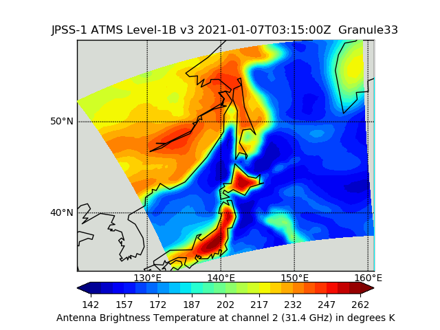
JPSS-1 ATMS Level 1B Brightness Temperature V3 (SNDRJ1ATMSL1B) at GES DISC recent views
The Advanced Technology Microwave Sounder (ATMS) Level 1B data files contain brightness temperature measurements along with ancillary spacecraft, instrument, and geolocation... -
Global Fire Emissions Database, Version 4.1 (GFEDv4) NGDA recent views
This dataset provides global estimates of monthly burned area, monthly emissions and fractional contributions of different fire types, daily or 3-hourly fields to scale the... -
MODIS/Terra+Aqua Land Cover Type Yearly L3 Global 500m SIN Grid V061 NGDA recent views
The Terra and Aqua combined Moderate Resolution Imaging Spectroradiometer (MODIS) Land Cover Type (MCD12Q1) Version 6.1 data product provides global land cover types at yearly... -
Global Maps of Atmospheric Nitrogen Deposition, 1860, 1993, and 2050 recent views
This data set provides global gridded estimates of atmospheric deposition of total inorganic nitrogen (N), NHx (NH3 and NH4+), and NOy (all oxidized forms of nitrogen other than... -
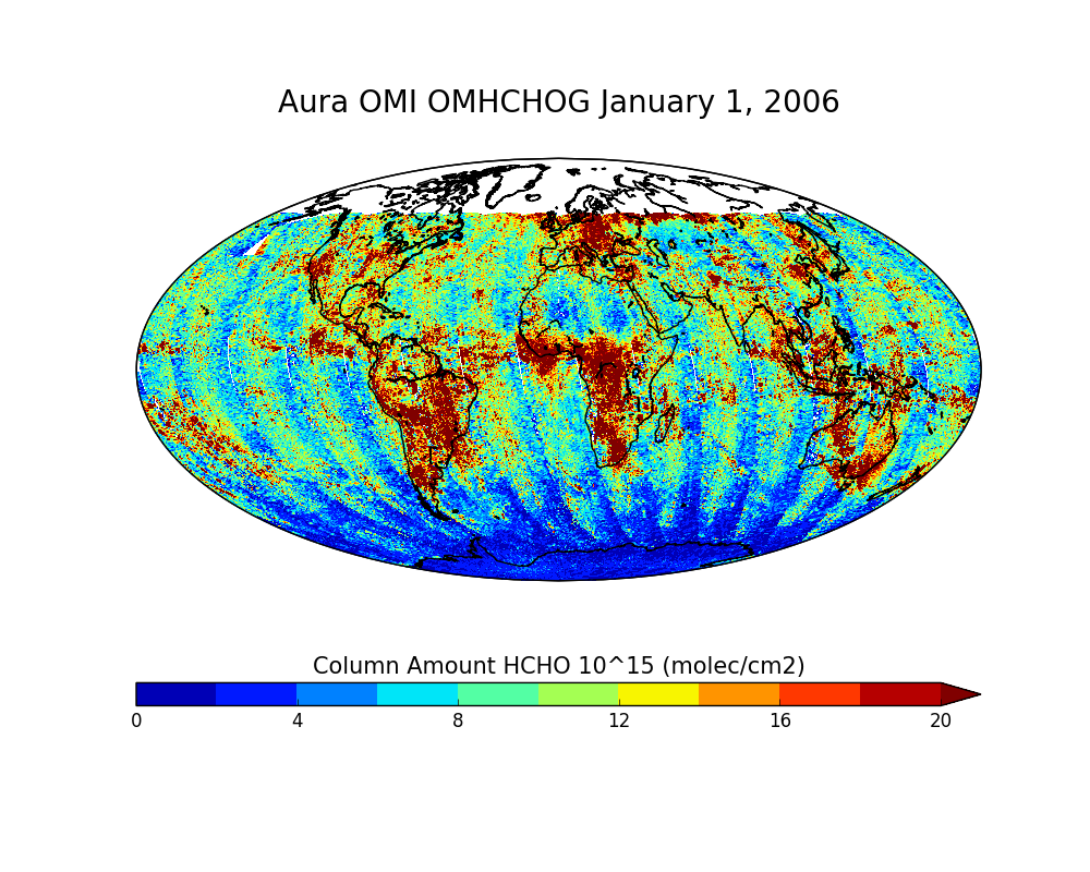
OMI/Aura Formaldehyde (HCHO) Total Column Daily L2 Global Gridded 0.25 degree x 0.25 degree V3 (OMHCHOG) at GES DISC recent views
This Level-2G daily global gridded product OMHCHOG is based on the pixel level OMI Level-2 HCHO product OMHCHO. OMHCHOG data product is a special Level-2 Global Gridded Product... -
Diagnosing Faults in Electrical Power Systems of Spacecraft and Aircraft recent views
Electrical power systems play a critical role in spacecraft and aircraft, and they exhibit a rich variety of failure modes. This paper discusses electrical power system fault... -
NCEP/CPC L3 Half Hourly 4km Global (60S - 60N) Merged IR V1 (GPM_MERGIR) at GES DISC recent views
These data originate from NOAA/NCEP. The NOAA Climate Prediction Center/NCEP/NWS is making the data available originally in binary format, in a weekly rotating archive. The NASA... -
An Adaptive Recurrent Neural Network for Remaining Useful Life Prediction of Lithium-ion Batteries recent views
Prognostics is an emerging science of predicting the health condition of a system (or its components) based upon current and previous system states. A reliable predictor is very... -
CYGNSS Level 3 Ocean Microplastic Concentration Version 3.2 recent views
The CYGNSS L3 Ocean Microplastic Concentration V3.2 dataset is provided by the CYGNSS Science Team of the University of Michigan. CYGNSS was launched on 15 December 2016, it is... -
Landsat-Derived Global Rainfed and Irrigated-Cropland Product 30 m V001 recent views
The Landsat-Derived Global Rainfed and Irrigated-Cropland Product (LGRIP) provides high resolution, global cropland data to assist and address food and water security issues of... -
GPM IMERG Early Precipitation L3 1 day 0.1 degree x 0.1 degree V06 (GPM_3IMERGDE) at GES DISC recent views
The Integrated Multi-satellitE Retrievals for GPM (IMERG) is the unified U.S. algorithm that provides the multi-satellite precipitation product for the U.S. GPM team. Version 06... -
Global Land Cover Mapping and Estimation Yearly 30 m V001 recent views
NASA’s Making Earth System Data Records for Use in Research Environments (MEaSUREs) Global Land Cover Mapping and Estimation (GLanCE) annual 30 meter (m) Version 1 data product... -
IRIS/Nimbus-4 Level 1 Radiance Data V001 (IRISN4RAD) at GES DISC recent views
The Nimbus-4 Infrared Interferometer Spectrometer (IRIS) Level 1 Radiance Data contain thermal emissions of the Earth's atmosphere at wave numbers between 400 and 1600 cm-1,... -
ECOSTRESS Land Surface Temperature and Emissivity Daily L2 Global 70m V001 recent views
The ECOsystem Spaceborne Thermal Radiometer Experiment on Space Station (ECOSTRESS) mission measures the temperature of plants to better understand how much water plants need... -
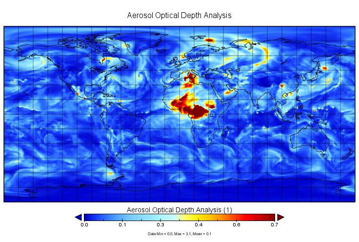
MERRA-2 inst3_2d_gas_Nx: 2d,3-Hourly,Instantaneous,Single-Level,Assimilation,Aerosol Optical Depth Analysis 0.625 x 0.5 degree V5.12.4 (M2I3NXGAS) at GES DISC recent views
M2I3NXGAS (or inst3_3d_gas_Nx) is an instantaneous 2-dimensional 3-hourly data collection in Modern-Era Retrospective analysis for Research and Applications version 2 (MERRA-2).... -
Aqua/AIRS L2 Standard Physical Retrieval (AIRS+AMSU) V7.0 at GES DISC recent views
The Atmospheric Infrared Sounder (AIRS) is a grating spectrometer (R = 1200) aboard the second Earth Observing System (EOS) polar-orbiting platform, EOS Aqua. The AIRS... -
MISR Geometric Parameters V003 recent views
MIB2GEOP_003 is the Multi-angle Imaging SpectroRadiometer (MISR) Geometric Parameters Version 3 product. It contains the Geometric Parameters which measure the sun and view... -
Prognostics Of Power Mosfets Under Thermal Stress Accelerated Aging Using Data-Driven And Model-Based Methodologies recent views
An approach for predicting remaining useful life of power MOSFETs (metal oxide field effect transistor) devices has been developed. Power MOSFETs are semiconductor switching...

Official websites use .gov
A
.gov website belongs to an official government
organization in the United States.
Secure .gov websites use HTTPS
A
lock (
) or https:// means you’ve safely connected to
the .gov website. Share sensitive information only on official,
secure websites.