
-
NACP North American Forest Dynamics Project: Forest Disturbance and Regrowth Data recent views
This data set provides the results of time-series analyses of Landsat imagery for 55 selected forested sites across the conterminous U.S.A. The output is a pair of disturbance... -
A Global Database of Gas Fluxes from Soils after Rewetting or Thawing, Version 1.0 recent views
This database contains information compiled from published studies on gas flux from soil following rewetting or thawing. The resulting database includes 222 field and laboratory... -
Methane Emissions from Dairy Sources (Vista-CA), State of California, USA, 2019 recent views
This dataset provides estimates of methane (CH4) emissions from dairies in California at a resolution of 0.1 degrees (~ 10 km x 10 km) for the year 2019. The mapped sources of... -
AirMOSS: L4 Modeled Volumetric Root Zone Soil Moisture, 2012-2015 recent views
This data set provides hourly gridded soil moisture estimates derived from hydrologic modeling at nine AirMOSS sites across North America. The AirMOSS L4 RZSM product represents... -
LBA-ECO ND-02 Agricultural and Secondary Forest Soil Trace Gas Flux, Para: 2001-2004 recent views
This data set reports the results of a study to measure soil emissions of the carbon dioxide (CO2), methane (CH4), and nitrous oxide (N2O), and nitric oxide (NO) throughout an... -
Global Soil Profile Data (ISRIC-WISE) recent views
The ISRIC-WISE International soil profile data set consists of a homogenized, global set of 1,125 soil profiles for use by global modelers. These profiles provided the basis for... -
Remote Sensing Data Before and After California Rim and King Forest Fires, 2010-2015 recent views
This data set provides high-resolution surface reflectance, thermal imagery, burn severity metrics, and LiDAR-derived structural measures of forested areas in the Sierra Nevada... -
NACP: Forest Carbon Stocks, Fluxes and Productivity Estimates, Western USA, 1979-2099 recent views
This dataset contains annual estimates of carbon stocks, fluxes, and productivity over forested land in 11 states of the western USA (Arizona, California, Colorado, Idaho,... -
LUH1: Harmonized Global Land Use for Years 1500-2100, V1 recent views
These data represent fractional land use and land cover patterns annually for the years 1500 - 2100 for the globe at 0.5-degree (~50-km) spatial resolution. Land use categories... -
Annual wildland fire emissions (WFEIS v0.5) for Conterminous US and Alaska, 2001-2013 NGDA recent views
This data set contains annual modeled estimates of wildland fire emissions at 0.01 degree (~1-km) spatial resolution from the Wildland Fire Emissions Information System (WFEIS... -
Global Forest Ecosystem Structure and Function Data For Carbon Balance Research recent views
A comprehensive global database has been assembled to quantify CO2 fluxes and pathways across different levels of integration (from photosynthesis up to net ecosystem... -
LBA-ECO ND-02 CO2 Flux from Soils in Forests and Pastures, Acre, Brazil: 1999-2001 recent views
This data set reports soil CO2 flux and results of physical and chemical characterization of soils from pastures, secondary forests, and mature forests near Rio Branco, Acre,... -
LBA-ECO CD-05 Understory Fuel Stick Moisture, km 67 Site, Para, Brazil: 1998-2000 recent views
This data set contains moisture content measurements for fuel sticks located in the forest understory of the rainfall exclusion experimental site, Tapajos National Forest, Para,... -
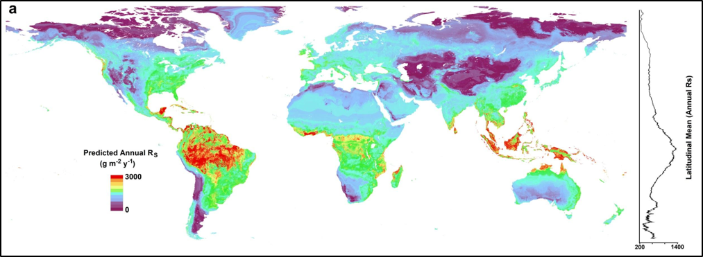
Global Gridded 1-km Annual Soil Respiration and Uncertainty Derived from SRDB V3 recent views
This dataset provides six global gridded products at 1-km resolution of predicted annual soil respiration (Rs) and associated uncertainty, maps of the lower and upper quartiles... -
Soil Carbon Estimates in 20-cm Layers to 1-meter Depth, Conterminous US, 1970-1993 recent views
This data set provides a soil map with estimates of soil carbon (C) in g C/m2 for 20-cm layers from the surface to one meter depth for the conterminous United States.STATSGO v.1... -
LBA-ECO TG-05 NPP, Carbon Pool, Soil Characteristics, Soil Gas Flux Maps of Brazil recent views
This data set provides maps produced from model output data from the National Aeronautics and Space Administration-Carnegie Ames Stanford Approach (NASA-CASA) model and other... -
CMS: Carbon Fluxes from Global Agricultural Production and Consumption, 2005-2011 recent views
This data set provides global estimates of carbon fluxes associate with annual crop net primary production (NPP) and harvested biomass, annual uptake and release by humans and...

Official websites use .gov
A
.gov website belongs to an official government
organization in the United States.
Secure .gov websites use HTTPS
A
lock (
) or https:// means you’ve safely connected to
the .gov website. Share sensitive information only on official,
secure websites.