Global Gridded 1-km Annual Soil Respiration and Uncertainty Derived from SRDB V3
Access & Use Information
Downloads & Resources
-
Google Scholar search resultsHTML
Search results for publications that cite this dataset by its DOI.
-
Download this datasetHTML
This link allows direct data access via Earthdata login
-
View documentation related to this datasetHTML
ORNL DAAC Data Set Documentation
-
This dataset's landing pageHTML
Data set Landing Page DOI URL
-
View documentation related to this datasetPDF
CMS: Global 1-km maps of predicted soil respiration and associated...
-
Get a related visualizationPNG
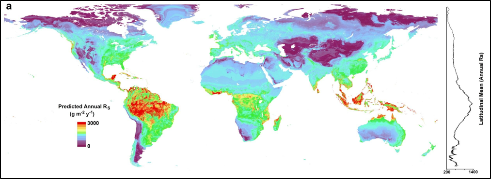
A global map of predicted annual soil respiration (Rs) at 1-km spatial...
-
Landing PageLanding Page
Dates
| Metadata Created Date | December 1, 2022 |
|---|---|
| Metadata Updated Date | December 7, 2023 |
Metadata Source
- Data.json Data.json Metadata
Harvested from NASA Data.json
Graphic Preview

Additional Metadata
| Resource Type | Dataset |
|---|---|
| Metadata Created Date | December 1, 2022 |
| Metadata Updated Date | December 7, 2023 |
| Publisher | ORNL_DAAC |
| Maintainer | |
| Identifier | C2389104778-ORNL_CLOUD |
| Data First Published | 2020-01-09 |
| Language | en-US |
| Data Last Modified | 2023-06-12 |
| Category | CMS, geospatial |
| Public Access Level | public |
| Bureau Code | 026:00 |
| Metadata Context | https://project-open-data.cio.gov/v1.1/schema/catalog.jsonld |
| Metadata Catalog ID | https://data.nasa.gov/data.json |
| Schema Version | https://project-open-data.cio.gov/v1.1/schema |
| Catalog Describedby | https://project-open-data.cio.gov/v1.1/schema/catalog.json |
| Citation | Warner, D.L., B.P. Bond-Lamberty, J. Jian, E. Stell, and R. Vargas. 2019. Global Gridded 1-km Annual Soil Respiration and Uncertainty Derived from SRDB V3. ORNL DAAC, Oak Ridge, Tennessee, USA. https://doi.org/10.3334/ORNLDAAC/1736 |
| Graphic Preview Description | A global map of predicted annual soil respiration (Rs) at 1-km spatial resolution created by applying the QRF model to gridded covariates. To the right is a plot of the latitudinal mean predicted annual Rs. (Figure from Warner et al., In Review). |
| Graphic Preview File | https://daac.ornl.gov/CMS/guides/CMS_Global_Soil_Respiration_Fig1.png |
| Harvest Object Id | 169fe760-439f-4091-ac2f-c0fbbd5ee573 |
| Harvest Source Id | 58f92550-7a01-4f00-b1b2-8dc953bd598f |
| Harvest Source Title | NASA Data.json |
| Homepage URL | https://doi.org/10.3334/ORNLDAAC/1736 |
| Metadata Type | geospatial |
| Old Spatial | -180.0 -90.0 180.0 90.0 |
| Program Code | 026:001 |
| Source Datajson Identifier | True |
| Source Hash | 489ecce836322420d5c2e46a0a4375d896274a8182234f363fa5b8625a7b5f2b |
| Source Schema Version | 1.1 |
| Spatial | |
| Temporal | 1963-01-01T00:00:00Z/2011-12-31T23:59:59Z |
Didn't find what you're looking for? Suggest a dataset here.

