
-
Sources of Methane Emissions (Vista-CA), State of California, USA recent views
This dataset provides spatial data products with identified and organized locations of potential methane (CH4) emitting facilities and infrastructure spanning the State of... -
CMS: LiDAR Data for Forested Sites on Borneo Island, Kalimantan, Indonesia, 2014 recent views
This dataset provides airborne LiDAR data collected over 90 sites totaling approximately 100,000 hectares of forested land in Kalimantan, Indonesia on the island of Borneo in... -
Tree Inventory and Biometry Measurements, Tapajos National Forest, Para, Brazil, 2010 recent views
This dataset provides tree inventory, tree height, diameter at breast height (DBH), and estimated crown measurements from 30 plots located in the Tapajos National Forest, Para,... -
ABoVE: Annual Thaw Slump Expansion on East Fork Chandalar River, Alaska, 2008-2017 recent views
This dataset provides a time series of spatial data showing the expansion of a thaw slump on the East Fork Chandalar River near the community of Venetie, Alaska, from 2008... -
Arctic Circumpolar Distribution and Soil Carbon of Thermokarst Landscapes, 2015 recent views
This data set provides the distribution of thermokarst landscapes in the boreal and tundra ecoregions within the northern circumpolar permafrost zones. This dataset provides an... -
Pre-ABoVE: Active Layer Thickness and Soil Water Content, Barrow, Alaska, 2013 recent views
This data set provides estimates of Active Layer Thickness (ALT) determined with ground-based measurements, and calculated soil volumetric water content (VWC) at four selected... -
ABoVE: Dall Sheep Lamb Recruitment and Climate Data, Alaska and NW Canada, 2000-2015 NGDA recent views
This dataset contains estimated annual average Dall sheep (Ovis dalli dalli) lamb-to-ewe ratios for each year from 2000-2015 across the full species range in Alaska and... -
ABoVE: Directory of Field Sites Associated with 2017 ABoVE Airborne Campaign recent views
This dataset provides a listing of the ~6,700 field sites used in planning the ABoVE Airborne Campaign (AAC) for 2017. The sites included point, polygon, and line locations that... -
NDVI, Species Cover, and LAI, Burned and Unburned sites, Interior Alaska, 2017-2018 NGDA recent views
This dataset provides leaf area index (LAI), tree species and canopy cover, normalized difference vegetation index (NDVI), and NDVI trends for boreal forests in interior Alaska,... -
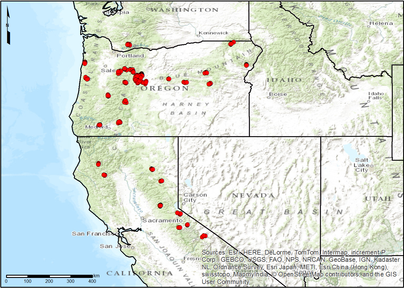
LiDAR Derived Forest Aboveground Biomass Maps, Northwestern USA, 2002-2016 recent views
This dataset provides maps of aboveground forest biomass (AGB) of living trees and standing dead trees in Mg/ha across portions of Northwestern United States, including... -
NACP Greenhouse Gases Multi-Source Data Compilation, 2000-2009 recent views
This data set is a collection of measurements of carbon dioxide (CO2) and non-CO2 greenhouse gases made across North America by nine independent atmospheric monitoring networks... -
CMS: LiDAR Data for Forested Areas in Paragominas, Para, Brazil, 2012-2014 recent views
This data set provides raw LiDAR point cloud data and derived Digital Terrain Models (DTMs) for five forested areas in the municipality of Paragominas, Para, Brazil, for the... -
ABoVE: Lake and Wetland Classification from L-band SAR, Alaska and Canada, 2017-2019 recent views
This dataset contains a high-resolution land cover classification focused on water and wetland vegetation classes over three NASA ABoVE Campaign regions: Yukon Flats, Alaska,... -
NACP TERRA-PNW: Forest Plant Traits, NPP, Biomass, and Soil Properties, 1999-2014 recent views
This data set contains measurements and estimates of leaf, tree, and soil data from six projects conducted by the Terrestrial Ecosystem Research and Regional Analysis- Pacific... -
ABoVE: Wetland Inundation Coverage at Yukon Flats, AK and PA Delta, Canada, 2017-2019 recent views
This dataset provides time series of wetland inundation coverage maps and corresponding inundation frequency maps at ~10-meter resolution estimated every 12 days during the... -
AfriSAR: Polarimetric Height Profiles by TomoSAR, Lope and Rabi Forests, Gabon, 2016 recent views
This dataset provides height profiles derived from UAVSAR (Uninhabited Aerial Vehicle Synthetic Aperture Radar; JPL) data acquired over Lope National Park and Rabi Forest in... -
Stocks of Surface Soil Organic Carbon Fractions, Great Plains Region, USA, 2007-2010 recent views
This dataset provides estimates of total organic soil carbon (SOC), pyrogenic (PyC), particulate (POC), and other organic soil carbon (OOC) fractions in 473 surface layer soil... -
ABoVE: Subsistence Resource Use Areas of Interior Alaskan Communities, 2011-2017 recent views
This dataset provide maps to show the search and harvest areas used by community residents for all subsistence resources combined across Interior Alaska for the years 2011... -
Landsat-derived Spring and Autumn Phenology, Eastern US - Canadian Forests, 1984-2013 recent views
This dataset provides Landsat phenology algorithm (LPA) derived start and end of growing seasons (SOS and EOS) at 500-m resolution for deciduous and mixed forest areas of 75... -
FLUXNET Research Network Site Characteristics, Investigators, and Bibliography, 2016 recent views
FLUXNET is a global network of micrometeorological tower sites that use eddy covariance methods to measure the exchanges of carbon dioxide, water vapor, and energy between...

Official websites use .gov
A
.gov website belongs to an official government
organization in the United States.
Secure .gov websites use HTTPS
A
lock (
) or https:// means you’ve safely connected to
the .gov website. Share sensitive information only on official,
secure websites.