ABoVE: Lake and Wetland Classification from L-band SAR, Alaska and Canada, 2017-2019
Access & Use Information
Downloads & Resources
-
Google Scholar search resultsHTML
Search results for publications that cite this dataset by its DOI.
-
Download this datasetHTML
This link allows direct data access via Earthdata login
-
View documentation related to this datasetHTML
ORNL DAAC Data Set Documentation
-
This dataset's landing pageHTML
Data set Landing Page DOI URL
-
View documentation related to this datasetHTML
ABoVE: Lake and Wetland Classification from L-band SAR, Alaska and Canada,...
-
View documentation related to this datasetHTML
ABoVE: Lake and Wetland Classification from L-band SAR, Alaska and Canada,...
-
View documentation related to this datasetHTML
ABoVE: Lake and Wetland Classification from L-band SAR, Alaska and Canada,...
-
View documentation related to this datasetHTML
ABoVE: Lake and Wetland Classification from L-band SAR, Alaska and Canada,...
-
View documentation related to this datasetPDF
ABoVE: Lake and Wetland Classification from L-band SAR, Alaska and Canada,...
-
View documentation related to this datasetKML
ABoVE: Lake and Wetland Classification from L-band SAR, Alaska and Canada,...
-
View documentation related to this datasetKML
ABoVE: Lake and Wetland Classification from L-band SAR, Alaska and Canada,...
-
Get a related visualizationJPEG
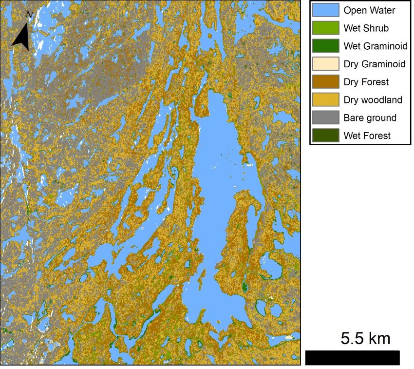
A preliminary wetland classification for Canadian Shield lakes north of...
-
The dataset's project home pageHTML
ABoVE project site
-
Landing PageLanding Page
Dates
| Metadata Created Date | December 1, 2022 |
|---|---|
| Metadata Updated Date | December 6, 2023 |
Metadata Source
- Data.json Data.json Metadata
Harvested from NASA Data.json
Graphic Preview

Additional Metadata
| Resource Type | Dataset |
|---|---|
| Metadata Created Date | December 1, 2022 |
| Metadata Updated Date | December 6, 2023 |
| Publisher | ORNL_DAAC |
| Maintainer | |
| Identifier | C2192619280-ORNL_CLOUD |
| Data First Published | 2021-12-21 |
| Language | en-US |
| Data Last Modified | 2023-06-12 |
| Category | ABoVE, geospatial |
| Public Access Level | public |
| Bureau Code | 026:00 |
| Metadata Context | https://project-open-data.cio.gov/v1.1/schema/catalog.jsonld |
| Metadata Catalog ID | https://data.nasa.gov/data.json |
| Schema Version | https://project-open-data.cio.gov/v1.1/schema |
| Catalog Describedby | https://project-open-data.cio.gov/v1.1/schema/catalog.json |
| Citation | Kyzivat, E.D., L.C. Smith, C. Huang, C. Wang, T. Langhorst, J.V. Fayne, M.E. Harlan, Y. Ishitsuka, D. Feng, L.H. Pitcher, and T.M. Pavelsky. 2021. ABoVE: Lake and Wetland Classification from L-band SAR, Alaska and Canada, 2017-2019. ORNL DAAC, Oak Ridge, Tennessee, USA. https://doi.org/10.3334/ORNLDAAC/1883 |
| Graphic Preview Description | A preliminary wetland classification for Canadian Shield lakes north of Yellowknife, NWT, Canada. Missing data in some lakes appear as white spots. Source: bakerc_16008_19059_012_190904_L090_CX_01_Freeman-inc_cls.tif |
| Graphic Preview File | https://daac.ornl.gov/ABOVE/guides/Lake_Wetland_Classes_UAVSAR_Fig1.jpg |
| Harvest Object Id | 9edf5893-a8c3-42ea-8edc-ecfa1d2880ff |
| Harvest Source Id | 58f92550-7a01-4f00-b1b2-8dc953bd598f |
| Harvest Source Title | NASA Data.json |
| Homepage URL | https://doi.org/10.3334/ORNLDAAC/1883 |
| Metadata Type | geospatial |
| Old Spatial | -149.16 53.71 -107.86 67.91 |
| Program Code | 026:001 |
| Source Datajson Identifier | True |
| Source Hash | 48be3daf57595a1a1d57755b5ce3865e0069e3b4575c1082f14af43068935c4f |
| Source Schema Version | 1.1 |
| Spatial | |
| Temporal | 2017-01-01T00:00:00Z/2019-09-19T23:59:59Z |
Didn't find what you're looking for? Suggest a dataset here.

