ABoVE: Wetland Inundation Coverage at Yukon Flats, AK and PA Delta, Canada, 2017-2019
Access & Use Information
Downloads & Resources
-
Google Scholar search resultsHTML
Search results for publications that cite this dataset by its DOI.
-
Download this datasetHTML
This link allows direct data access via Earthdata login
-
View documentation related to this datasetHTML
ORNL DAAC Data Set Documentation
-
This dataset's landing pageHTML
Data set Landing Page DOI URL
-
View documentation related to this datasetPDF
ABoVE: Wetland Inundation Coverage at Yukon Flats, AK and PA Delta, Canada,...
-
View documentation related to this datasetKML
ABoVE: Wetland Inundation Coverage at Yukon Flats, AK and PA Delta, Canada,...
-
View documentation related to this datasetKML
ABoVE: Wetland Inundation Coverage at Yukon Flats, AK and PA Delta, Canada,...
-
Get a related visualizationPNG
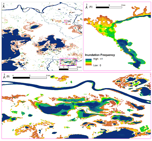
2017-2019 inundation frequency of the Peace-Athabasca Delta, Canada. From...
-
The dataset's project home pageHTML
ABoVE project site
-
Landing PageLanding Page
Dates
| Metadata Created Date | May 30, 2023 |
|---|---|
| Metadata Updated Date | December 6, 2023 |
Metadata Source
- Data.json Data.json Metadata
Harvested from NASA Data.json
Graphic Preview

Additional Metadata
| Resource Type | Dataset |
|---|---|
| Metadata Created Date | May 30, 2023 |
| Metadata Updated Date | December 6, 2023 |
| Publisher | ORNL_DAAC |
| Maintainer | |
| Identifier | C2482179223-ORNL_CLOUD |
| Data First Published | 2022-09-22 |
| Language | en-US |
| Data Last Modified | 2023-06-12 |
| Category | ABoVE, geospatial |
| Public Access Level | public |
| Bureau Code | 026:00 |
| Metadata Context | https://project-open-data.cio.gov/v1.1/schema/catalog.jsonld |
| Metadata Catalog ID | https://data.nasa.gov/data.json |
| Schema Version | https://project-open-data.cio.gov/v1.1/schema |
| Catalog Describedby | https://project-open-data.cio.gov/v1.1/schema/catalog.json |
| Citation | Huang, C., L.C. Smith, E.D. Kyzivat, J.V. Fayne, and C. Spence. 2021. ABoVE: Wetland Inundation Coverage at Yukon Flats, AK and PA Delta, Canada, 2017-2019. ORNL DAAC, Oak Ridge, Tennessee, USA. https://doi.org/10.3334/ORNLDAAC/1901 |
| Graphic Preview Description | 2017-2019 inundation frequency of the Peace-Athabasca Delta, Canada. From Huang et al., 2021. |
| Graphic Preview File | https://daac.ornl.gov/ABOVE/guides/InundationMap_YkFlats_PeaceAth_Fig1.png |
| Harvest Object Id | 0296b2da-b4eb-4c5a-9bbb-34443ead46d3 |
| Harvest Source Id | 58f92550-7a01-4f00-b1b2-8dc953bd598f |
| Harvest Source Title | NASA Data.json |
| Homepage URL | https://doi.org/10.3334/ORNLDAAC/1901 |
| Metadata Type | geospatial |
| Old Spatial | -146.43 58.25 -110.92 66.81 |
| Program Code | 026:001 |
| Source Datajson Identifier | True |
| Source Hash | ddb85c6e3812c6a0b69c1b4707c8e3a5d09c0044bacef2abfbedd8c75fa69c14 |
| Source Schema Version | 1.1 |
| Spatial | |
| Temporal | 2017-05-21T00:00:00Z/2019-10-26T23:59:59Z |
Didn't find what you're looking for? Suggest a dataset here.

