MASTER: Flight Line Geospatial Polygons and Contextual Data
Access & Use Information
Downloads & Resources
-
Google Scholar search resultsHTML
Search results for publications that cite this dataset by its DOI.
-
Download this datasetHTML
This link allows direct data access via Earthdata login
-
View documentation related to this datasetHTML
ORNL DAAC Data Set Documentation
-
This dataset's landing pageHTML
Data set Landing Page DOI URL
-
View documentation related to this datasetPDF
MASTER: Flight Line Geospatial Polygons and Contextual Data:...
-
Get a related visualizationJPEG
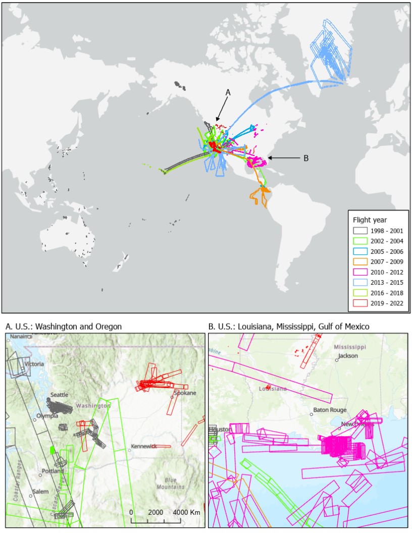
Distribution of MASTER flight lines over Greenland, North America, and...
-
Landing PageLanding Page
Dates
| Metadata Created Date | July 27, 2023 |
|---|---|
| Metadata Updated Date | February 12, 2024 |
Metadata Source
- Data.json Data.json Metadata
Harvested from NASA Data.json
Graphic Preview

Additional Metadata
| Resource Type | Dataset |
|---|---|
| Metadata Created Date | July 27, 2023 |
| Metadata Updated Date | February 12, 2024 |
| Publisher | ORNL_DAAC |
| Maintainer | |
| Identifier | C2731799041-ORNL_CLOUD |
| Data First Published | 2024-02-01 |
| Language | en-US |
| Data Last Modified | 2024-02-06 |
| Category | MASTER, FIREX-AQ, HyspIRI Airborne, SARP, TC4, WDTS, geospatial |
| Public Access Level | public |
| Bureau Code | 026:00 |
| Metadata Context | https://project-open-data.cio.gov/v1.1/schema/catalog.jsonld |
| Metadata Catalog ID | https://data.nasa.gov/data.json |
| Schema Version | https://project-open-data.cio.gov/v1.1/schema |
| Catalog Describedby | https://project-open-data.cio.gov/v1.1/schema/catalog.json |
| Citation | Hook, S.J., E.W. Fraim, R.O. Green, J.S. Myers, K.J. Thome, M. Fitzgerald, A.B. Kahle, and Airborne Sensor Facility NASA Ames Research Center. 2023. MASTER: Flight Line Geospatial Polygons and Contextual Data. ORNL DAAC, Oak Ridge, Tennessee, USA. https://doi.org/10.3334/ORNLDAAC/2151 |
| Graphic Preview Description | Distribution of MASTER flight lines over Greenland, North America, and Pacific Ocean for 1998 to 2022. Insets show details of flights in the U.S. over (A) Washington and Oregon and (B) Louisiana, Mississippi, and Gulf of Mexico. Footprints of acquired imagery are shown as rectangular polygons. |
| Graphic Preview File | https://daac.ornl.gov/MASTER/guides/MASTER_Flightline_Locator_Fig1.jpg |
| Harvest Object Id | b899ff38-9078-4d61-aa1f-a8c5f39788c2 |
| Harvest Source Id | 58f92550-7a01-4f00-b1b2-8dc953bd598f |
| Harvest Source Title | NASA Data.json |
| Homepage URL | https://doi.org/10.3334/ORNLDAAC/2151 |
| Metadata Type | geospatial |
| Old Spatial | -171.99 -55.38 179.47 78.68 |
| Program Code | 026:001 |
| Source Datajson Identifier | True |
| Source Hash | b43006c2d2aa9a7f08f5c55bfe98f5a2c7d5799f9201ffe1799aa56025ffcac9 |
| Source Schema Version | 1.1 |
| Spatial | |
| Temporal | 1998-12-02T00:00:01Z/2023-05-02T23:59:59Z |
Didn't find what you're looking for? Suggest a dataset here.

