
-
Federal
TRMM Attitude and VIRS Packets and Header Record L1A V7 (TRMM_1A01) at GES DISC
National Aeronautics and Space Administration —
The Level-1A Product file, "1A01", is a concatenation of Header record, Spacecraft Attitude packets, VIRS Housekeeping Data packets, VIRS Science Data packets, QACs,... -
Federal
ACES Aircraft and Mechanical Data V1
National Aeronautics and Space Administration —
The ACES Aircraft and Mechanical Data consist of aircraft (e.g. pitch, roll, yaw) and mechanical (e.g. aircraft engine speed, tail commands, fuel levels) data... -
Federal
Mission Reports IMPACTS V1
National Aeronautics and Space Administration —
The Mission Reports IMPACTS dataset consists of flight plans, plans of the day, science plans, and science summaries logged by scientists during the Investigation of... -
Federal
OLCI+SLSTR/Sentinel-3A L2 Surface Reflectance and Aerosol parameters over Land
National Aeronautics and Space Administration —
The OLCI+SLSTR/Sentinel-3A L2 Surface Reflectance and Aerosol parameters over Land product with shortname S3A_SY_2_SYN, is generated by combining data acquired by the... -
Federal
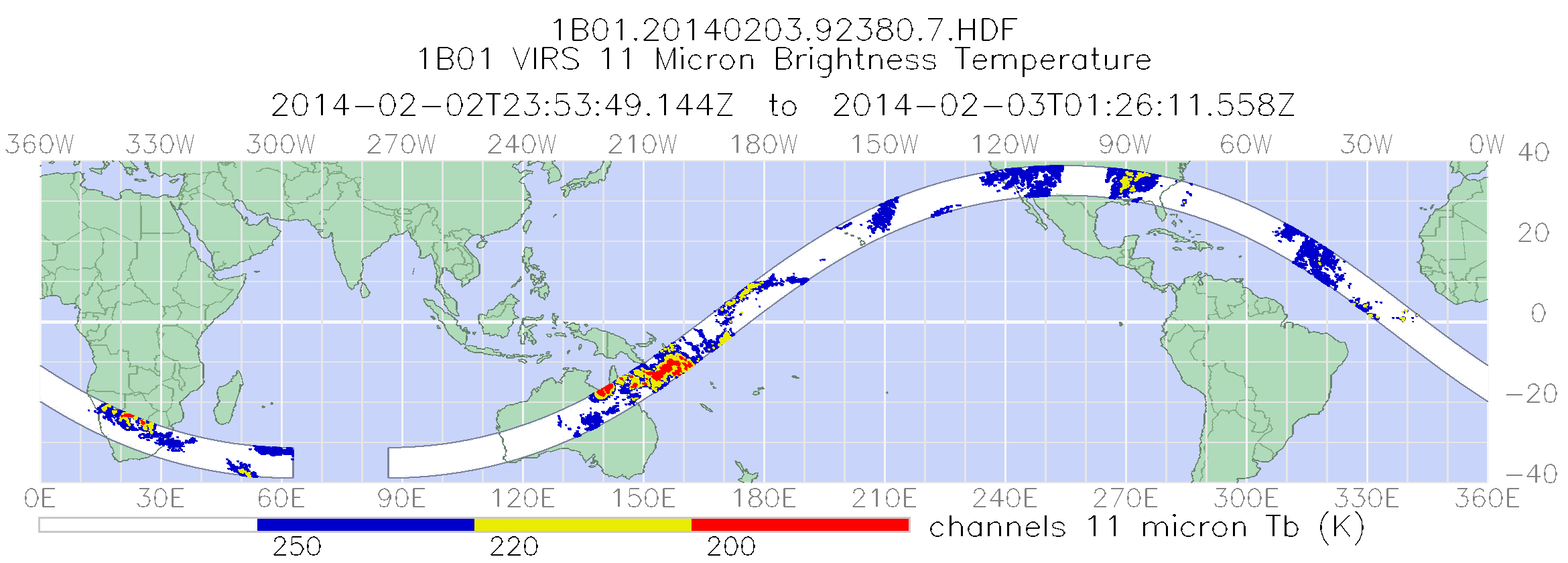
TRMM Visible and Infrared Scanner Calibrated Radiances L1B 1.5 hours V7 (TRMM_1B01) at GES DISC
National Aeronautics and Space Administration —
This TRMM Visible and Infrared Scanner (VIRS) Level 1B Calibrated Radiance Product (1B01) contains calibrated radiances and auxiliary geolocation information from the... -
Federal
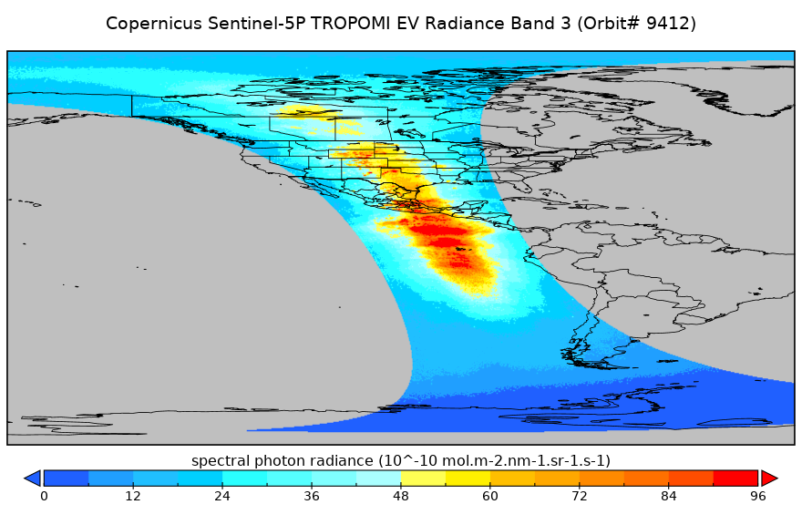
Sentinel-5P TROPOMI Near-Real-Time (NRT) Radiance product band 3 (UVIS detector) L1B 5.5km x 3.5km V2 (S5P_L1B_RA_BD3_HiR_NRT) at GES DISC
National Aeronautics and Space Administration —
The Sentinel-5P TROPOMI Near Real Time (NRT) Radiance product band 3 (UVIS detector) L1B 5.5km x 21km V2 (S5P_L1B_RA_BD3_HiR_NRT_NRT) product at GES DISC is the near... -
Federal
SMAP_L1A_RADAR_RECEIVE_ONLY_METADATA_V001
National Aeronautics and Space Administration —
SMAP Level 1A Radar Receive Only Product Metadata Version 1 -
Federal
TRMM Visible and Infrared Scanner Calibrated Radiances L1B 1.5 hours V7 (TRMM_1B01) at GES DISC
National Aeronautics and Space Administration —
This TRMM Visible and Infrared Scanner (VIRS) Level 1B Calibrated Radiance Product (1B01) contains calibrated radiances and auxiliary geolocation information from the... -
Federal
Sentinel-5P TROPOMI Radiance product band 5 (NIR detector) L1B 5.5km x 3.5km V2 (S5P_L1B_RA_BD5_HiR) at GES DISC
National Aeronautics and Space Administration —
Starting from August 6th in 2019, Sentinel-5P TROPOMI along-track high spatial resolution (~5.5km at nadir) has been implemented. For data before August 6th of 2019,... -
Federal
SMAP_L1C_SIGMA_NAUGHT_HIGH_RES_METADATA_V002
National Aeronautics and Space Administration —
SMAP Level 1C Sigma Naught High Res Product Metadata Version 2 -
Federal
GLAS/ICESat L1A Global Laser Pointing Data (HDF5) V033
National Aeronautics and Space Administration —
Level-1A global laser pointing data (GLAH04) contain two orbits of attitude data from the spacecraft star tracker, instrument star tracker, gyro, and laser reference... -
Federal
GOES-R PLT ER-2 Flight Navigation Data V1
National Aeronautics and Space Administration —
The GOES-R PLT ER-2 Flight Navigation Data dataset consists of multiple altitude, pressure, temperature parameters, airspeed, and ground speed measurements collected... -
Federal
CAMEX-3 DC-8 NAVIGATION (DADS) DATA V1
National Aeronautics and Space Administration —
The CAMEX-3 DC-8 Navigation Data Acquisition and Distribution System (DADS) data files contain information recorded by navigation and data collection systems onboard... -
Federal
TRACE-P In Situ DC-8 Meteorology and Navigation Data
National Aeronautics and Space Administration —
TRACE-P_MetNav_AircraftInSitu_DC8_Data is the in situ meteorology and navigation data collected onboard the DC-8 aircraft during the Transport and Chemical Evolution... -
Federal
OCO-2 Level 0 spacecraft attitude data, Retrospective Processing V10r (OCO2_Att) at GES DISC
National Aeronautics and Space Administration —
Version 10r is the current version of the data set. Older versions will no longer be available and are superseded by Version 10r. Version 8r is the current version of... -
Federal
OLCI/Sentinel-3B L1 Full Resolution Top of Atmosphere Reflectance
National Aeronautics and Space Administration —
The OLCI/Sentinel-3B L1 Full Resolution Top of Atmosphere Reflectance product, S3B_OL_1_EFR is generated from the data aquired by the Ocean and Land Colour Instrument... -
Federal
DC-8 Meteorological and Navigation Data CPEX-AW V1
National Aeronautics and Space Administration —
The DC-8 Meteorological and Navigation Data CPEX-AW dataset is a subset of airborne measurements that include GPS positioning and trajectory data, aircraft... -
Federal
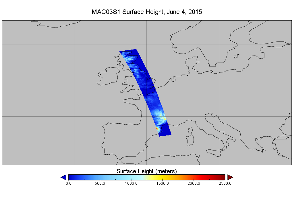
MODIS/Aqua Geolocation Fields 1km 5-Min 1A Wide Swath Subset along CloudSat V002 (MAC03S1) at GES DISC NGDA
National Aeronautics and Space Administration —
This is the wide-swath MODIS/Aqua subset along CloudSat field of view track. The goal of the wide-swath subset is to select and return MODIS data that are within... -
Federal
SMAP_L1B_SIGMA_NAUGHT_LOW_RES_V003
National Aeronautics and Space Administration —
SMAP Level 1B Sigma Naught Low Res Product Version 3 -
Federal
OCO-2 Level 0 spacecraft ephemerides, Retrospective Processing V11r (OCO2_Eph) at GES DISC
National Aeronautics and Space Administration —
Version 11r is the current version of the data set. Older versions will no longer be available and are superseded by Version 11r. The Orbiting Carbon Observatory is...

Official websites use .gov
A
.gov website belongs to an official government
organization in the United States.
Secure .gov websites use HTTPS
A
lock (
) or https:// means you’ve safely connected to
the .gov website. Share sensitive information only on official,
secure websites.