

17 datasets found
-
Federal
Utah FORGE: Well 58-32 Core Analyses
Department of Energy —
This dataset contains final reports regarding stress measurements, permeability measurements, and mechanical properties from the core testing of well 58-32, in PDF... -
Federal
Fort Bliss Geothermal Area Data: Temperature Profile, Logs, Schematic Model and Cross Section
Department of Energy —
This dataset contains a variety of data about the Fort Bliss geothermal area, part of the southern portion of the Tularosa Basin, New Mexico. The dataset contains... -
Federal
WHOLESCALE: Coordinates of wells at San Emidio, Nevada
Department of Energy —
This dataset includes position coordinates and elevation information for wells at the WHOLESCALE San Emidio project location. Well positions in the attached file are... -
Federal
Utah FORGE: Well 16A(78)-32 Planned Trajectory
Department of Energy —
This submission includes an Excel spreadsheet containing the Utah FORGE deep well 16A(78)-32 planned trajectory including UTM coordinates, elevations, and depths from... -
Federal
Utah FORGE: Beaver Basin Wildcat Well Lu Lu State #1 Dip Meter and Neutron Density Logs
Department of Energy —
This dataset contains Schlumberger dip meter and neutron density logs for Lu Lu State #1 wild cat well which is located in the Beaver Basin, Beaver County, Utah.... -
Federal
Utah FORGE: Phase 2C Seismic Observation and Ground Water Well Data and Well Locations
Department of Energy —
This submission contains the following data associated with Utah FORGE Phase 2C within the Roosevelt Hot Springs geothermal area: - An ArcGIS shapefile with well... -
Federal
Compilation of lithologic data from public supply well completion reports submitted to the California Department of Water Resources (ver. 3.0 July 2025)
Department of the Interior —
This data release was prepared as part of an agreement between the California Department of Water Resources (DWR) and the United States Geological Survey (USGS) to... -
Federal
Brady Well Coordinates and Observation Sensor Depths
Department of Energy —
Contains metadata associated with the wells used in the 2016 Spring Campaign led partially by UW - Madison, LBNL, and LLNL scientists. Included with the well... -
Federal
Utah FORGE: Regional Well Locations
Department of Energy —
This archive contains a GIS point feature shapefile that shows the locations of wells in the general region of the Utah FORGE project, near Roosevelt Hot Springs.... -
Federal
Utah FORGE: Pressure Temperature Logs from Blundell Well 71-10, Beaver County
Department of Energy —
This archive contains an Excel spreadsheet with pressure and temperature logs from PacifiCorp well 71-10. This well is in the Blundell Power Plant geothermal well... -
Federal
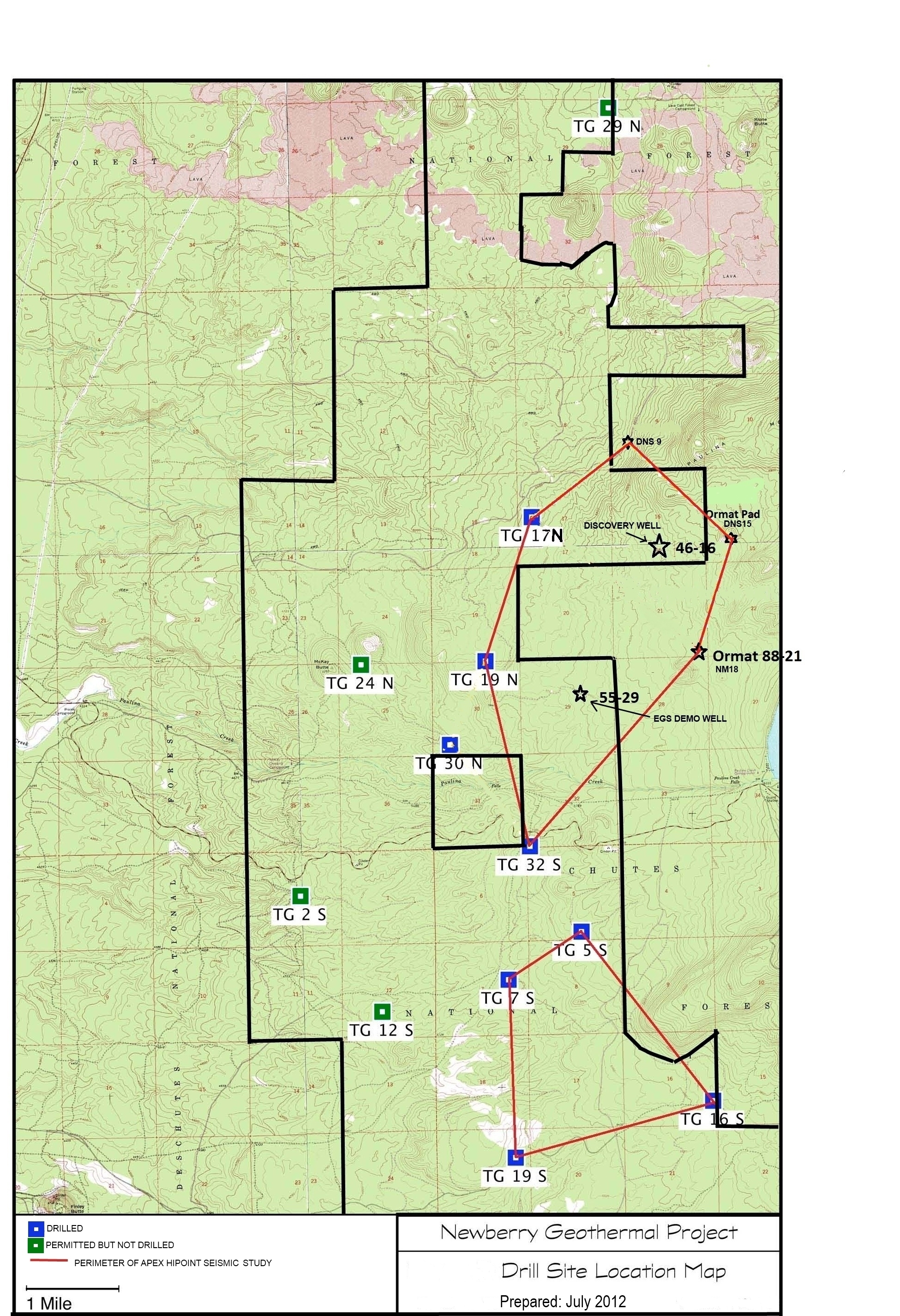
Validation of Innovative Exploration Technologies for Newberry Volcano: Drill Site Location Map
Department of Energy —
Newberry seeks to explore "blind" (no surface evidence) convective hydrothermal systems associated with a young silicic pluton on the flanks of Newberry Volcano. This... -
Federal
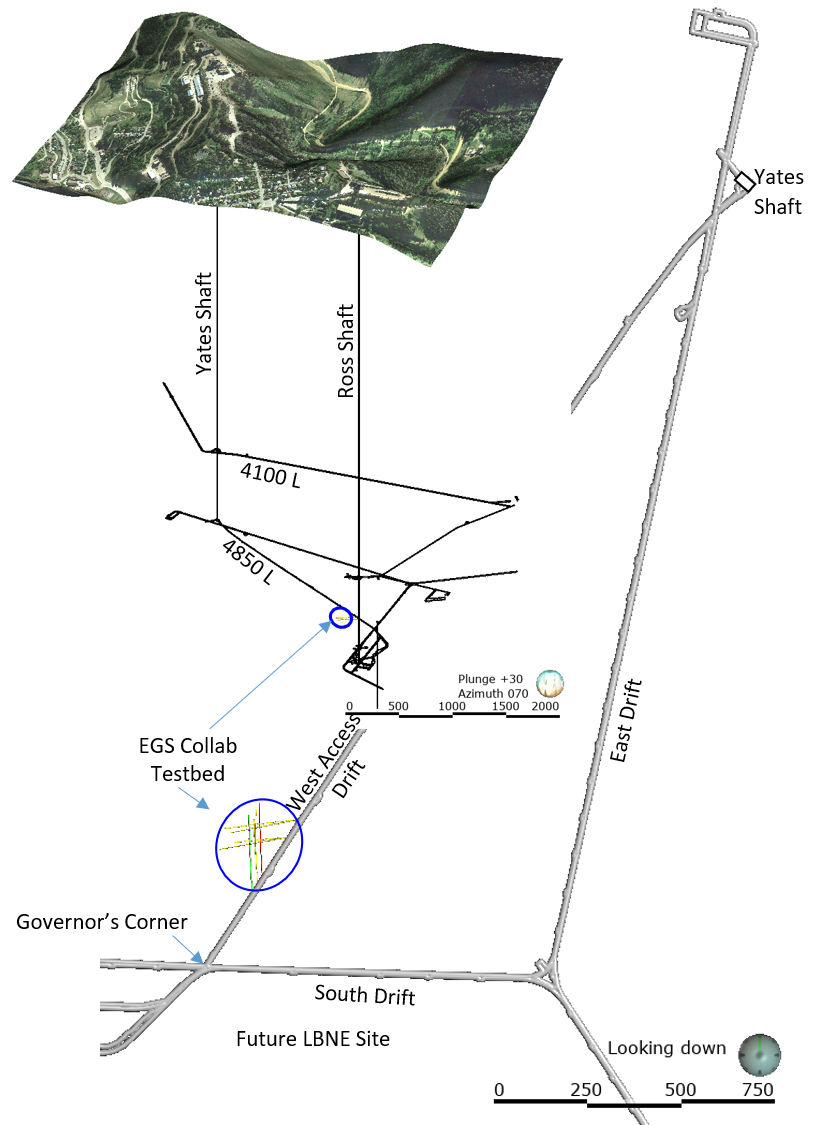
EGS Collab Experiment 2: Preliminary Test Wells Locations and Orientations
Department of Energy —
The EGS Collab project is evaluating a site for Experiment 2 (hydraulic fracturing/shearing) at a depth of 1.25 km in the Sanford Underground Research Facility (SURF)... -
Federal
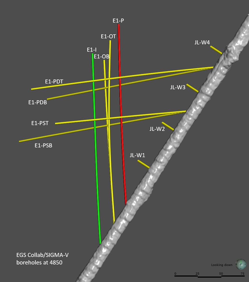
EGS Collab Experiment 1: Well Locations and Orientations.
Department of Energy —
The EGS Collab is conducting experiments in hydraulic fracturing at a depth of 1.5 km in the Sanford Underground Research Facility (SURF) on the 4850 Level. A total... -
Federal
Map of Validation of Innovative Exploration Technologies for Newberry Volcano
Department of Energy —
A map showing location of wells permitted, drilled and seismic test, as part of validation of innovative exploration technologies done for the Newberry Volcano... -
Federal
Utah FORGE: Updated Phase 2C Well Location Coordinates
Department of Energy —
Utah FORGE has been established to develop, test, and improve the technologies and techniques required to develop EGS-type geothermal resources. Drilling of the first...
17 datasets found