

EGS Collab Experiment 1: Well Locations and Orientations.
Access & Use Information
Public: This dataset is intended for public access and use.
License:
Creative Commons Attribution
Downloads & Resources
-
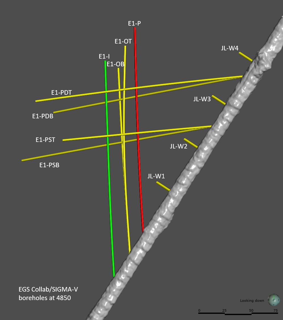
EGS_Collab_holes_at_4850.pngPNG
Well layout.
-
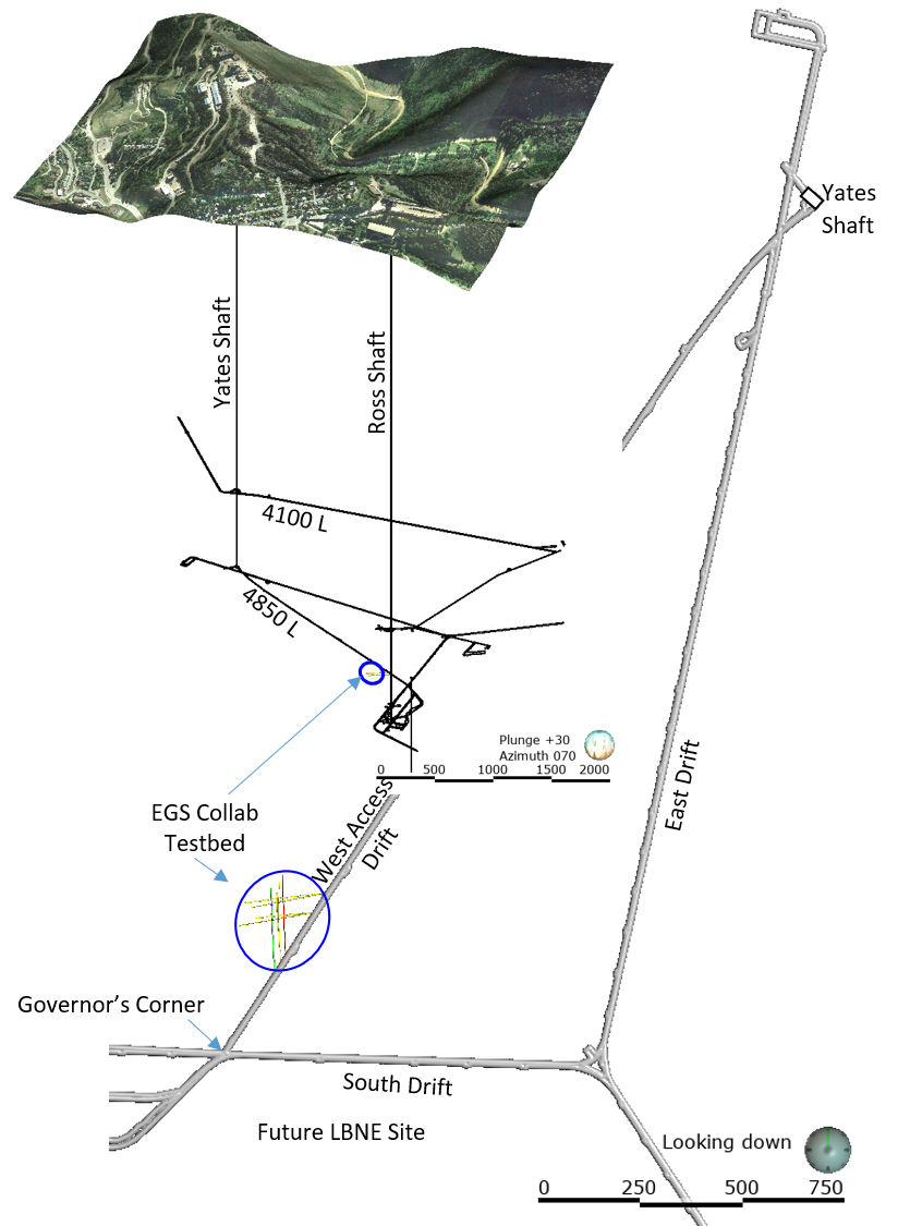
Location of EGS_Collab_test_bed-1.pngPNG
Location of test bed.
-
E1-Jack_Leg_holes_Az_gyro_09_05_2018.csvCSV
Jack leg holes gyro data
-
E1-OB Az Gyro_09_05_2018.csvCSV
E1-OB gyro data
-
E1-OT Az Gyro_09_05_2018.csvCSV
E1-OT gyro data
-
E1-I Az Gyro_09_05_2018.csvCSV
E1-I gyro data
-
E1-P Az Gyro_09_05_2018.csvCSV
E1-P gyro data
-
E1-PDB Az Gyro_09_05_2018.csvCSV
E1-PDB gyro data
-
E1-PDT Az Gyro_09_05_2018.csvCSV
E1-PDT gyro data
-
E1-PSB Az Gyro_09_05_2018.csvCSV
E1-PSB gyro data
-
E1-PST Az Gyro_09_05_2018.csvCSV
E1-PST gyro data
-
Collar_Locations_for_Sigma-V_holes.csvCSV
Well head locations.
-
Landing PageLanding Page
Dates
| Metadata Created Date | January 11, 2025 |
|---|---|
| Metadata Updated Date | January 20, 2025 |
Metadata Source
- Data.json Data.json Metadata
Harvested from OpenEI data.json
Additional Metadata
| Resource Type | Dataset |
|---|---|
| Metadata Created Date | January 11, 2025 |
| Metadata Updated Date | January 20, 2025 |
| Publisher | Idaho National Laboratory |
| Maintainer | |
| Doi | 10.15121/1576950 |
| Identifier | https://data.openei.org/submissions/7318 |
| Data First Published | 2018-09-05T06:00:00Z |
| Data Last Modified | 2023-10-19T01:15:01Z |
| Public Access Level | public |
| Bureau Code | 019:20 |
| Metadata Context | https://openei.org/data.json |
| Metadata Catalog ID | https://openei.org/data.json |
| Schema Version | https://project-open-data.cio.gov/v1.1/schema |
| Catalog Describedby | https://project-open-data.cio.gov/v1.1/schema/catalog.json |
| Data Quality | True |
| Datagov Dedupe Retained | 20250120155001 |
| Harvest Object Id | 8930a6ae-fa06-4d1d-af8b-a81ed841edfa |
| Harvest Source Id | 7cbf9085-0290-4e9f-bec1-91653baeddfd |
| Harvest Source Title | OpenEI data.json |
| Homepage URL | https://gdr.openei.org/submissions/1184 |
| License | https://creativecommons.org/licenses/by/4.0/ |
| Old Spatial | {"type":"Polygon","coordinates":-103.7577,44.3488,-103.7465,44.3488,-103.7465,44.3544,-103.7577,44.3544,-103.7577,44.3488} |
| Program Code | 019:006 |
| Projectlead | Lauren Boyd |
| Projectnumber | EE0032708 |
| Projecttitle | EGS Collab |
| Source Datajson Identifier | True |
| Source Hash | dc51606d560a2eebfba0c6091e3a112cc9ad8750249acc7b1bdf5de93b74ed5c |
| Source Schema Version | 1.1 |
| Spatial | {"type":"Polygon","coordinates":-103.7577,44.3488,-103.7465,44.3488,-103.7465,44.3544,-103.7577,44.3544,-103.7577,44.3488} |
Didn't find what you're looking for? Suggest a dataset here.