

Map of Validation of Innovative Exploration Technologies for Newberry Volcano
Access & Use Information
Public: This dataset is intended for public access and use.
License:
Creative Commons Attribution
Downloads & Resources
-
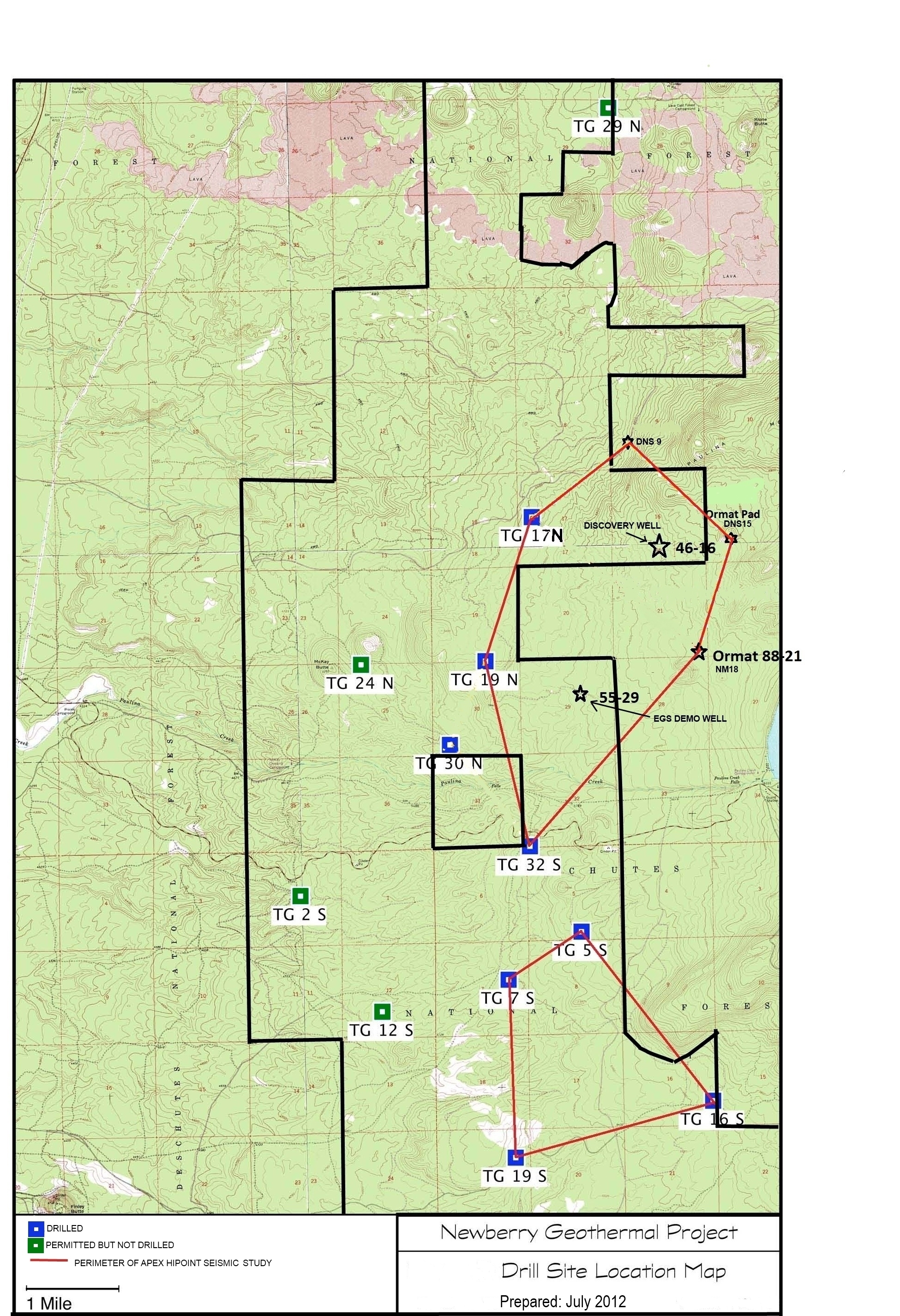
Drill Site Location Map.jpgJPEG
Map showing TGWs permitted, drilled and seismic testing area.
-
Landing PageLanding Page
Dates
| Metadata Created Date | January 11, 2025 |
|---|---|
| Metadata Updated Date | January 20, 2025 |
Metadata Source
- Data.json Data.json Metadata
Harvested from OpenEI data.json
Additional Metadata
| Resource Type | Dataset |
|---|---|
| Metadata Created Date | January 11, 2025 |
| Metadata Updated Date | January 20, 2025 |
| Publisher | Davenport Newberry Holdings, LLC |
| Maintainer | |
| Doi | 10.15121/1261913 |
| Identifier | https://data.openei.org/submissions/6504 |
| Data First Published | 2012-07-01T06:00:00Z |
| Data Last Modified | 2019-11-14T23:17:30Z |
| Public Access Level | public |
| Bureau Code | 019:20 |
| Metadata Context | https://openei.org/data.json |
| Metadata Catalog ID | https://openei.org/data.json |
| Schema Version | https://project-open-data.cio.gov/v1.1/schema |
| Catalog Describedby | https://project-open-data.cio.gov/v1.1/schema/catalog.json |
| Data Quality | True |
| Datagov Dedupe Retained | 20250120143002 |
| Harvest Object Id | 5ed6dcbe-3534-4141-b6c8-e8ec3f09209e |
| Harvest Source Id | 7cbf9085-0290-4e9f-bec1-91653baeddfd |
| Harvest Source Title | OpenEI data.json |
| Homepage URL | https://gdr.openei.org/submissions/144 |
| License | https://creativecommons.org/licenses/by/4.0/ |
| Old Spatial | {"type":"Polygon","coordinates":-121.30016944444,43.716491666667,-121.30016944444,43.716491666667,-121.30016944444,43.716491666667,-121.30016944444,43.716491666667,-121.30016944444,43.716491666667} |
| Program Code | 019:006 |
| Projectlead | Mark Ziegenbein |
| Projectnumber | EE0002833 |
| Projecttitle | DOE Innovative Exploration Technology (IET) Grant 109 program supporting geothermal exploration of Newberry Volcano, Oregon |
| Source Datajson Identifier | True |
| Source Hash | 030cdb6dad4db816d33778510e14aeb365c36f00409d73cccef91aabb9c7374d |
| Source Schema Version | 1.1 |
| Spatial | {"type":"Polygon","coordinates":-121.30016944444,43.716491666667,-121.30016944444,43.716491666667,-121.30016944444,43.716491666667,-121.30016944444,43.716491666667,-121.30016944444,43.716491666667} |
Didn't find what you're looking for? Suggest a dataset here.