

193 datasets found
-
Federal
data.hrsa.gov (HRSA Data Warehouse)
U.S. Department of Health & Human Services —
DATA.HRSA.GOV is the go-to source for data, dashboards, maps, reports, locators, APIs and downloadable data files on HRSA's public health programs, including: HRSA-... -
State
CA Geographic Boundaries
State of California —
This dataset contains shapefile boundaries for CA State, counties and places from the US Census Bureau's 2023 MAF/TIGER database. Current geography in the 2023... -
Federal
National Mine Map Repository Mine Locations
Department of the Interior —
The National Mine Map Repository (NMMR) maintains point locations for mines appearing on maps within its archive. This dataset is intended to help connect the Office... -
County
King County Parcel Viewer
King County, Washington —
Parcel Viewer makes searching for King County parcel information easy. You can search by address, search by parcel number, or you can just zoom in on the map and... -
Federal
Community Planning and Development (CPD) Maps System
Department of Housing and Urban Development —
CPD Maps includes data on the locations of existing CDBG, HOME, public housing and other HUD-funded community assets, so that users can view past investments... -
State
MD iMAP: Maryland Property Data - Parcel Points
State of Maryland —
This is a MD iMAP hosted service layer. Find more information at http://imap.maryland.gov. Please Note: Due to the extensive size of the parcel points file -... -
Federal
Gazetteer of Planetary Nomenclature: Moon: 1:1 million-scale maps of the Moon
National Aeronautics and Space Administration —
The purpose of the lunar maps is to provide an up-to-date and comprehensive depiction on lunar nomenclature approved by the International Astronomical Union (IAU). -
State
MD iMAP: Maryland Property Data - Tax Map Grids
State of Maryland —
This is a MD iMAP hosted service layer. Find more information at http://imap.maryland.gov. This layer contains the boundaries and IDs of the Maryland tax maps... -
City
Texas Department of Transportation Traffic Safety Data Portal
City of Austin —
See statewide data and traffic safety categories data. -
Federal
Frontier and Remote Area Codes
Department of Agriculture —
Frontier and Remote Area (FAR) codes provide a statistically-based, nationally-consistent, and adjustable definition of territory in the U.S. characterized by low... -
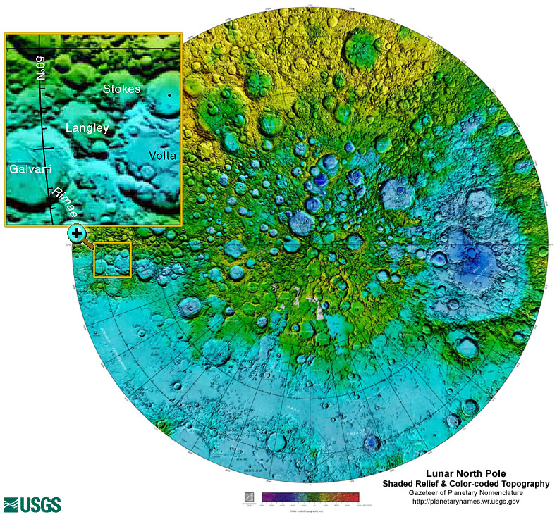
Federal
Gazetteer of Planetary Nomenclature: Moon: 1:10 million-scale Shaded Relief and Color-coded Topography: North Pole
National Aeronautics and Space Administration —
These lunar maps display the four different areas of the moon with color-coded topography in low and high resolution approved by the International Astronomical Union... -
Federal
GIBS Web Map Tile Service (WMTS)
National Aeronautics and Space Administration —
The WMTS implementation standard provides a standards-based solution for serviing digital maps using predefined image tiles. Through the constructs of the... -
Federal
Great Lakes Bathymetry
National Oceanic and Atmospheric Administration, Department of Commerce —
Bathymetry of Lakes Michigan, Erie, Saint Clair, Ontario and Huron has been compiled as a component of a NOAA project to rescue Great Lakes lake floor geological and... -
City
Fire Hydrants
City of Bloomington —
This data layer contains the locations of fire hydrants in Bloomington, Indiana. Hydrants owned by City of Bloomington Utilities (CBU) and privately owned hydrants... -
Federal
SSC 4D Orbit Viewer Web Services API at the Space Physics Data Facility (SPDF)
National Aeronautics and Space Administration —
This API allows any web application to offer an interactive 4D display of the trajectories of satellites known to SSCweb (Satellite Situation Center). The Space... -
City
Georeferenced NYC Zoning Maps
City of New York —
The Georeferenced NYC Zoning Maps raster dataset is intended to be a spatial representation of the entire zoning map catalog for the City of New York as one seamless... -
City
Sidewalk Inventory
City of Bloomington —
This data layer represents the sidewalks located along roadways for the City of Bloomington. It includes sidewalks maintained by the City of Bloomington as well as... -
Federal
Ag and Food Statistics: Charting the Essentials
Department of Agriculture —
A collection of over 75 charts and maps presenting key statistics on the farm sector, food spending and prices, food security, rural communities, the interaction of...
193 datasets found