

84 datasets found
-
Federal
Super-Resolution for Renewable Resource Data and Urban Heat Islands (Sup3rUHI)
Department of Energy —
Super-Resolution for Renewable Resource Data and Urban Heat Islands (Sup3rUHI) introduces machine learning methods to incorporate high-resolution Urban Heat Island... -
Federal
VIIRS Plus DMSP Change in Lights (VIIRS+DMSP dLIGHT)
National Aeronautics and Space Administration —
The VIIRS Plus DMSP Change in Lights (VIIRS+DMSP dLIGHT) data set fuses nighttime lights imagery from the U.S. Air Force Defense Meteorological Satellite Program... -
Federal
Compendium of Environmental Sustainability Indicator Collections: The Wellbeing of Nations
National Aeronautics and Space Administration —
The Wellbeing of Nations portion of the Compendium of Environmental Sustainability Indicator Collections contains a subset of 123 variables assembled from the... -
Federal
2001 Environmental Sustainability Index (ESI)
National Aeronautics and Space Administration —
The 2001 Environmental Sustainability Index (ESI) utilizes a refined methodology based on the 2000 Pilot ESI effort, to construct an index covering 122 countries that... -
Federal
Compendium of Environmental Sustainability Indicator Collections: 2004 Environmental Vulnerability Index (EVI)
National Aeronautics and Space Administration —
The 2004 Environmental Vulnerability Index (EVI) portion of the Compendium of Environmental Sustainability Indicator Collections contains 111 variables for 235... -
City
Louisville Metro KY - Urban Heat Island Neighborhood Data
Louisville Metro Government —
Mayor Greg Fischer formed the Louisville Metro Office of Sustainability in 2012 with a mission of promoting environmental conservation, the health, wellness and... -
City
4.04 Solid Waste Landfill Diversion (dashboard)
City of Tempe —
This operations dashboard shows historic and current data related to this performance measure.The performance measure dashboard is available at 4.04 Solid Waste... -
City
DPD council districts shore clip - Relative % Change
City of Seattle —
This data layer references data from a high-resolution tree canopy change-detection layer for Seattle, Washington. Tree canopy change was mapped by using remotely... -
City
Seattle Tree Canopy 2016 2021 Council Districts
City of Seattle —
This data layer references data from a high-resolution tree canopy change-detection layer for Seattle, Washington. Tree canopy change was mapped by using remotely... -
Federal
Time-Series Data on the Ocean and Great Lakes Economy for Counties, States, and the Nation between 2005 and 2017 (Sector and Industry Level)
National Oceanic and Atmospheric Administration, Department of Commerce —
Economics: National Ocean Watch (ENOW) contains annual time-series data for about 400 coastal counties, 30 coastal states, and the nation, derived from the Bureau of... -
Federal
Compendium of Environmental Sustainability Indicator Collections: Complete Collection, Version 1.1
National Aeronautics and Space Administration —
The Compendium of Environmental Sustainability Indicator Collections, Version 1.1 contains 426 indicators for 239 countries from five major environmental... -
Federal
Time-Series Data on the Ocean and Great Lakes Economy for Counties, States, and the Nation between 2005 and 2019 (Sector Level)
National Oceanic and Atmospheric Administration, Department of Commerce —
Economics: National Ocean Watch (ENOW) contains annual time-series data for over 400 coastal counties, 30 coastal states, 8 regions, and the nation, derived from the... -
Federal
2005 Environmental Sustainability Index (ESI)
National Aeronautics and Space Administration —
The 2005 Environmental Sustainability Index (ESI) is a measure of overall progress towards environmental sustainability, developed for 146 countries. The index... -
City
Seattle Tree Canopy 2016 2021 Public Schools
City of Seattle —
This data layer references data from a high-resolution tree canopy change-detection layer for Seattle, Washington. Tree canopy change was mapped by using remotely... -
City
Public Schools - Existing TC Percent
City of Seattle —
This data layer references data from a high-resolution tree canopy change-detection layer for Seattle, Washington. Tree canopy change was mapped by using remotely... -
Federal
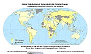
Synthetic Assessment of Global Distribution of Vulnerability to Climate Change: Maps and Data, 2005, 2050, and 2100
National Aeronautics and Space Administration —
The Synthetic Assessment of Global Distribution of Vulnerability to Climate Change: Maps and Data, 2005, 2050, and 2100 data set consist of maps and vulnerability... -
Federal
Relative Bycatch:Target Catch Probability Product (daily), EcoCast Project
National Oceanic and Atmospheric Administration, Department of Commerce —
The Relative Bycatch:Target Catch Probability Product is produced using a data-driven, multi-species predictive habitat modelling framework. First, boosted regression... -
County
Adopt A Highway Program
Lake County, Illinois —
Available, unavailable and adopted sections of county roads as part of Lake County's Division of Transportation Adopt A Highway Program -
City
Public Schools - Relative % Change
City of Seattle —
This data layer references data from a high-resolution tree canopy change-detection layer for Seattle, Washington. Tree canopy change was mapped by using remotely...
84 datasets found