

67 datasets found for ""Tree Heights""
-
Federal
BOREAS TE-23 Map Plot Data
National Aeronautics and Space Administration —
The BOREAS TE-23 team collected map plot data in support of its efforts to characterize and interpret information on canopy architecture and understory cover at the... -
City
Seattle Tree Canopy 2021 Tree Crowns
City of Seattle —
This dataset represents tree crowns derived from LiDAR data. Tree crowns are defined as circles that fitted to the approximated radius of a tree's branches and... -
Federal
CMS: Forest Inventory and Biophysical Measurements, Para, Brazil, 2012-2014
National Aeronautics and Space Administration —
This data set provides measurements for diameter at breast height (DBH), commercial tree height, and total tree height for forest inventories taken at the Fazenda... -
DC Tree Structure and Benefits
District of Columbia —
DC 2022 LiDAR was used and processed using the “Extract Trees using Cluster Analysis” script which is included as part of Esri’s 3D Basemap solution. All LiDAR-derived... -
Federal
Puerto Rico Above Ground Biomass Map, 2000
U.S. Environmental Protection Agency —
This image dataset details the U.S. Commonwealth of Puerto Rico above-ground forest biomass (AGB) (baseline 2000) developed by the United States (US) Environmental... -
State
Tree Characteristics - Spears and Didion Ranches [ds320]
State of California —
These data are the characteristics of the individual live trees found in 0.05-ha circular plot habitat samples taken in 2005 at sample points at Spears and Didion... -
State
Tree Characteristics - Spears and Didion Ranches [ds320]
State of California —
4" dbh and within the 12.6 m radius plot. If a plot number is missing, then there were no trees at the sample points and vegetation plots. -
City
Seattle Tree Centroids 2021
City of Seattle —
This dataset represents tree centroids derived from LiDAR data. The tree centroids are the estimated location of the central point of each tree. The tree centroids... -
Federal
Biomass of Sacrificed Spruce/Aspen (SNF)
National Aeronautics and Space Administration —
The purpose of the SNF study was to improve our understanding of the relationship between remotely sensed observations and important biophysical parameters in the... -
Federal
LBA-ECO CD-17 Secondary Forest Survey, Para and Rondonia, Brazil: 2002-2003
National Aeronautics and Space Administration —
This data set provides measurements for diameter at breast height (DBH), tree height, distance from tree stems to the furthest canopy element, and a species survey of... -
DC Estimated Trees
District of Columbia —
Dataset estimates location and size of trees in the District of Columbia that are not managed by the Urban Forestry Division (https://opendata.dc.gov/datasets/urban-... -
Federal
BOREAS TE-08 Aspen Bark Chemistry Data
National Aeronautics and Space Administration —
The BOREAS TE-08 team collected pigment density data from aspen bark and leaves from four sites within the BOREAS SSA from 24-May-1994 to 16-Jun-1994 (IFC-1),... -
Federal
SAFARI 2000 Canopy Structural Measurements, Kalahari Transect, Wet Season 2001
National Aeronautics and Space Administration —
This data set contains leaf area index (LAI), leaf inclination angle, and canopy dimension data from study sites along the Kalahari Transect in southwest Botswana.... -
Federal
Forest Inventory and Biophysical Measurements, Brazilian Amazon, 2009-2018
National Aeronautics and Space Administration —
This dataset provides the complete catalog of forest inventory and biophysical measurements collected over selected forest research sites across the Amazon rainforest... -
State
Tree Characteristics - Spears and Didion Ranches [ds320]
State of California —
These data are the characteristics of the individual live trees found in 0.05-ha circular plot habitat samples taken in 2005 at sample points at Spears and Didion... -
Federal
Environmental and Vegetation Data from Marsh-Forest Transgression Experiment at Blackwater National Wildlife Refuge, MD, USA
Department of the Interior —
We conducted a field experiment at the Moneystump Swamp in the Blackwater National Wildlife Refuge in Dorchester, MD, USA to simulate a natural forest disturbance... -
Federal
SNF Forest Understory Cover Data
National Aeronautics and Space Administration —
The purpose of the SNF study was to improve our understanding of the relationship between remotely sensed observations and important biophysical parameters in the... -
State
Tree Characteristics - Spears and Didion Ranches [ds320] Extended Table
State of California —
These data are the characteristics of the individual live trees found in 0.05-ha circular plot habitat samples taken in 2005 at sample points at Spears and Didion... -
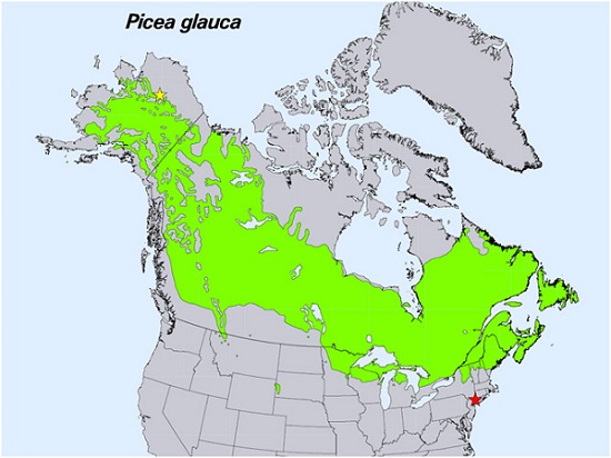
Federal
Spruce Leaf, Tree Traits, and Respiration at Range Extremes, AK and NY, USA, 2018
National Aeronautics and Space Administration —
This dataset provides in situ measurements of needle-level gas-exchange and leaf traits from Picea glauca (white spruce) from a field site located in the northern...
67 datasets found for ""Tree Heights""