
-
Federal
China Dimensions Data Collection: China Administrative Regions GIS Data: 1:1M, County Level, 1990
National Aeronautics and Space Administration —
The China Administrative Regions GIS Data: 1:1M, County Level, 1990 consists of geographic boundary data for the administrative regions of China as of 31 December... -
Federal
China Dimensions Data Collection: GuoBiao (GB) Codes for the Administrative Divisions of the Peoples Republic of China
National Aeronautics and Space Administration —
The GuoBiao (GB) Codes for the Administrative Divisions of the People's Republic of China consists of geographic codes for the administrative divisions of China. The... -
Federal
Potential Impacts of Climate Change on World Food Supply: Datasets from a Major Crop Modeling Study
National Aeronautics and Space Administration —
The Potential Impacts of Climate Change on World Food Supply: Datasets from a Major Crop Modeling Study contain projected country and regional changes in grain crop... -
Federal
China Dimensions Data Collection: China County-Level Data from Provincial Economic Yearbooks, Keyed to 1:1M GIS Map
National Aeronautics and Space Administration —
The China County-Level Data on Provincial Economic Yearbooks, Keyed To 1:1M GIS Map consists of socioeconomic and boundary data for the administrative regions of... -
Federal
China Dimensions Data Collection: China County-Level Data on Population (Census) and Agriculture, Keyed to 1:1M GIS Map
National Aeronautics and Space Administration —
The China County-Level Data on Population (Census) and Agriculture, Keyed To 1:1M GIS Map consists of census, agricultural economic, and boundary data for the... -
Federal
China Dimensions Data Collection: Fundamental GIS: Digital Chart of China, 1:1M, Version 1
National Aeronautics and Space Administration —
The Fundamental GIS: Digital Chart of China, 1:1M, Version 1 consists of vector maps of China and surrounding areas. The maps include roads, railroads, drainage... -
Federal
Effects of Climate Change on Global Food Production from SRES Emissions and Socioeconomic Scenarios
National Aeronautics and Space Administration —
The Effects of Climate Change on Global Food Production from SRES Emissions and Socioeconomic Scenarios is an update to a major crop modeling study by the NASA... -
Federal
China Dimensions Data Collection: Chinese County-Level Data on Hospitals and Epidemiology Stations, 1950-1985
National Aeronautics and Space Administration —
The China Dimensions Data Collection: Chinese County-Level Data on Hospitals and Epidemiology Stations, 1950-1985 consists of hospital and epidemiological station... -
Federal
Global Gridded Relative Deprivation Index (GRDI), Version 1
National Aeronautics and Space Administration —
The Global Gridded Relative Deprivation Index (GRDI), Version 1 (GRDIv1) data set characterizes the relative levels of multidimensional deprivation and poverty in... -
Federal
Annual Mean PM2.5 Components (EC, NH4, NO3, OC, SO4) 50m Urban and 1km Non-Urban Area Grids for Contiguous U.S., 2000-2019 v1
National Aeronautics and Space Administration —
The Annual Mean PM2.5 Components (EC, NH4, NO3, OC, SO4) 50m Urban and 1km Non-Urban Area Grids for Contiguous U.S., 2000-2019, v1 data set contains annual... -
Federal
China Dimensions Data Collection: Bibliography of Chinese Administrative Geography
National Aeronautics and Space Administration —
The Bibliography of Chinese Administrative Geography is a historical collection of bibliographic information on 75 published books describing the administrative... -
Federal
China Dimensions Data Collection: China Administrative Regions GIS Data: 1:1M, County Level, 1 July 1990
National Aeronautics and Space Administration —
The China Administrative Regions GIS Data: 1:1M, County Level, 1 July 1990 consists of geographic boundary data for the administrative regions of China as of 1 July... -
Federal
West Africa Coastal Vulnerability Mapping: Subset of High and Low Resolution Altimeter Corrected Elevations 2 (ACE2)
National Aeronautics and Space Administration —
The West Africa Coastal Vulnerability Mapping: Subset of High and Low Resolution Altimeter Corrected Elevations 2 (ACE2) data set consists of extracts from the 3 arc-... -
Federal
Indicators of Coastal Water Quality: Annual Chlorophyll-a Concentration 1998-2007
National Aeronautics and Space Administration —
The Annual Chlorophyll-a Concentrations component of the Indicators of Coastal Water Quality Collection consists of gridded satellite measurements of chlorophyll-a... -
Federal
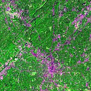
Urban Landsat: Cities from Space
National Aeronautics and Space Administration —
The Urban Landsat: Cities from Space data set contains images for 66 urban areas and the raw, underlying data for 28 of these places. Each image shows a Landsat false... -
Federal
SDG Indicator 11.7.1: Urban Public Space, Availability and Access, 2023 Release
National Aeronautics and Space Administration —
The SDG Indicator 11.7.1: Urban Public Space, Availability and Access, 2023 Release, part of the SDGI collection, measures the average share of the built-up area of a...

Official websites use .gov
A
.gov website belongs to an official government
organization in the United States.
Secure .gov websites use HTTPS
A
lock (
) or https:// means you’ve safely connected to
the .gov website. Share sensitive information only on official,
secure websites.