
-
Federal
Global Maps of Atmospheric Nitrogen Deposition, 1860, 1993, and 2050 11 recent views
National Aeronautics and Space Administration —
This data set provides global gridded estimates of atmospheric deposition of total inorganic nitrogen (N), NHx (NH3 and NH4+), and NOy (all oxidized forms of nitrogen... -
Federal
CMS: LiDAR Data for Forested Areas in Paragominas, Para, Brazil, 2012-2014
National Aeronautics and Space Administration —
This data set provides raw LiDAR point cloud data and derived Digital Terrain Models (DTMs) for five forested areas in the municipality of Paragominas, Para, Brazil,... -
Federal
ABoVE: Photochemical Reflectance and Tree Growth, Brooks Range, Alaska, 2018-2019
National Aeronautics and Space Administration —
This dataset provides simultaneous in-situ measurements of the photochemical reflectance index (PRI) and radial tree growth of selected white spruce trees (Picea... -
Federal
RLC Forest Cover of the Former Soviet Union, 1973
National Aeronautics and Space Administration —
This data set is a 1:15 million scale forest cover map for the land area of the Former Soviet Union. Twenty-two land cover classes are distinguished, of which 20 are... -
Federal
Global Gridded Surfaces of Selected Soil Characteristics (IGBP-DIS)
National Aeronautics and Space Administration —
Global data-surfaces pre-generated by SoilData, at a resolution of 5x5 arc-minutes, in ASCII GRID format for ARC INFO, and for the soil depth interval 0-100 cm. -
Federal
Global Soil Types, 0.5-Degree Grid (Modified Zobler)
National Aeronautics and Space Administration —
A global data set of soil types is available at 0.5-degree latitude by 0.5-degree longitude resolution. There are 106 soil units, based on Zobler's (1986) assessment... -
Federal
SAFARI 2000 MOPITT Tropospheric Carbon Monoxide, Southern Africa, Dry Season 2000
National Aeronautics and Space Administration —
The MOPITT (Measurements Of Pollution In The Troposphere) instrument on the NASA Terra Satellite makes measurements of infrared radiation originating from the surface... -
Federal
Characteristics of African Savanna Biomes for Determining Woody Cover
National Aeronautics and Space Administration —
This data set includes the soil and vegetation characteristics, herbivore estimates, and precipitation measurement data for the 854 sites described and analyzed in... -
Federal
CMS: Aboveground Biomass from Penobscot Experimental Forest, Maine, 2012
National Aeronautics and Space Administration —
This data set includes estimates of aboveground biomass (AGB) in 2012 from the Penobscot Experimental Forest (PEF) in Bradley, Maine. The AGB was modeled using LiDAR... -
Federal
FLUXNET Research Network Site Characteristics, Investigators, and Bibliography, 2016
National Aeronautics and Space Administration —
FLUXNET is a global network of micrometeorological tower sites that use eddy covariance methods to measure the exchanges of carbon dioxide, water vapor, and energy... -
Federal
LBA-ECO LC-14 Biophysical Measurements, Rainfall Exclusion, Tapajos National Forest
National Aeronautics and Space Administration —
This data set reports forest biophysical measurements from a rainfall exclusion experiment conducted at the km 67 Seca Floresta site, Tapajos National Forest, Brazil... -
Federal
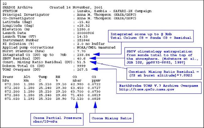
SAFARI 2000 SHADOZ Ozonesonde Data, Zambia and Regional Sites, Dry Season 2000
National Aeronautics and Space Administration —
Ozonesonde launches were made by the Southern Hemisphere ADditional OZonesondes (SHADOZ) group as part of the SAFARI 2000 Dry Season Campaign in September 2000... -
Federal
Russian Boreal Forest Disturbance Maps Derived from Landsat Imagery, 1984-2000 NGDA
National Aeronautics and Space Administration —
This data set provides Boreal forest disturbance maps at 30-m resolution for 55 selected sites across Northern Eurasia within the Russian Federation. Disturbance... -
Federal
Northern and Mid-Latitude Soil Database, Version 1, R1
National Aeronautics and Space Administration —
The U.S. Department of Agriculture, Agriculture and Agri-Food Canada, the Russian Academy of Agricultural Sciences, the University of Copenhagen Institute of... -
Federal
Phenoregions For Monitoring Vegetation Responses to Climate Change
National Aeronautics and Space Administration —
The overall purpose in this research was to identify the regions of the world best suited for long-term monitoring of biospheric responses to climate change, i.e.,... -
Federal
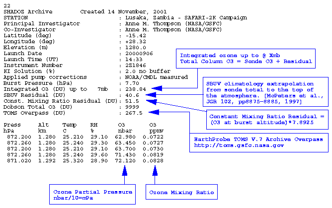
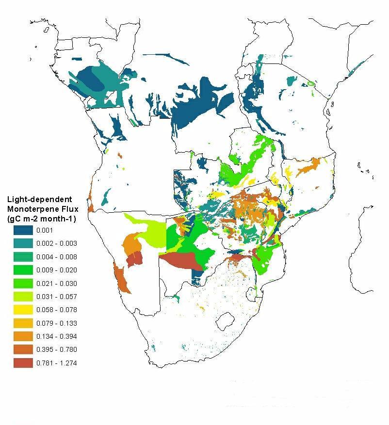
SAFARI 2000 Estimated BVOC Emissions for Southern African Land Cover Types NGDA
National Aeronautics and Space Administration —
Improved vegetation distribution and emission data for Africa south of the equator were developed for the Southern African Regional Science Initiative (SAFARI 2000)... -
Federal
RLC AVHRR-Derived Land Cover, Former Soviet Union, 15-km, 1984-1993
National Aeronautics and Space Administration —
This dataset is a 15-kilometer resolution land cover map for the land area of the Former Soviet Union. There are sixty land cover classes distinguished in this... -
Federal
RLC AVHRR-Derived Land Cover, Former Soviet Union, Far East, 1-km, 1990
National Aeronautics and Space Administration —
This data set is a 1-kilometer resolution land cover map for the land area of the Primor'ye and Southern Khabarovsk Regions, in the Russian Far East, based on 1990... -
Federal
RLC Forest Stand Carbon Map of Russia
National Aeronautics and Space Administration —
This dataset is a 1:15 million scale map of forest stand carbon for the land area of Russia (Stone et al., 2000). The objective was to create a first approximation of... -
Federal
Forest Inventories and DBH at Burned and Unburned Forest Sites, Acre, Brazil, 2017
National Aeronautics and Space Administration —
This data set provides measurements of diameter at breast height (DBH) and species identification at four forest sites in the eastern side of Acre, Brazil including...

Official websites use .gov
A
.gov website belongs to an official government
organization in the United States.
Secure .gov websites use HTTPS
A
lock (
) or https:// means you’ve safely connected to
the .gov website. Share sensitive information only on official,
secure websites.