

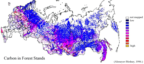
RLC Forest Stand Carbon Map of Russia
Access & Use Information
Public: This dataset is intended for public access and use.
License: No license information was provided. If this work was prepared by an officer or employee of the United States government as part of that person's official duties it is considered a U.S. Government Work.
Downloads & Resources
-
Google Scholar search resultsHTML
Search results for publications that cite this dataset by its DOI.
-
Download this datasetHTML
This link allows direct data access via Earthdata login
-
View documentation related to this datasetHTML
ORNL DAAC Data Set Documentation
-
This dataset's landing pageHTML
Data set Landing Page DOI URL
-
View documentation related to this datasetJPEG
Data Set Documentation
-
View documentation related to this datasetHTML
Data Set Documentation
-
View documentation related to this datasetHTML
Data Set Documentation
-
View documentation related to this datasetGIF
Data Set Documentation
-
View documentation related to this datasetPDF
Data Set Documentation
-
Get a related visualizationPNG
Browse Image
-
Landing PageLanding Page
Dates
| Metadata Created Date | December 6, 2023 |
|---|---|
| Metadata Updated Date | December 6, 2023 |
Metadata Source
- Data.json Data.json Metadata
Harvested from NASA Data.json
Graphic Preview
Additional Metadata
| Resource Type | Dataset |
|---|---|
| Metadata Created Date | December 6, 2023 |
| Metadata Updated Date | December 6, 2023 |
| Publisher | ORNL_DAAC |
| Maintainer | |
| Identifier | C2810671753-ORNL_CLOUD |
| Data First Published | 2023-11-21 |
| Language | en-US |
| Data Last Modified | 2023-12-02 |
| Category | Vegetation, geospatial |
| Public Access Level | public |
| Bureau Code | 026:00 |
| Metadata Context | https://project-open-data.cio.gov/v1.1/schema/catalog.jsonld |
| Metadata Catalog ID | https://data.nasa.gov/data.json |
| Schema Version | https://project-open-data.cio.gov/v1.1/schema |
| Catalog Describedby | https://project-open-data.cio.gov/v1.1/schema/catalog.json |
| Citation | Stone, T.A., P. Schlesinger, and V.A. Alexeyev. 2003. RLC Forest Stand Carbon Map of Russia. ORNL DAAC, Oak Ridge, Tennessee, USA. http://dx.doi.org/10.3334/ORNLDAAC/696 |
| Graphic Preview Description | Browse Image |
| Graphic Preview File | https://daac.ornl.gov/graphics/browse/project/square/vegetation_logo_square.png |
| Harvest Object Id | 2c5fb57c-78e2-4b87-89c7-3cca3827727f |
| Harvest Source Id | 58f92550-7a01-4f00-b1b2-8dc953bd598f |
| Harvest Source Title | NASA Data.json |
| Homepage URL | https://doi.org/10.3334/ORNLDAAC/696 |
| Metadata Type | geospatial |
| Old Spatial | 19.82 35.17 170.0 75.0 |
| Program Code | 026:001 |
| Source Datajson Identifier | True |
| Source Hash | 533945b87745e2c25d9c89bf7898c92ef7bbd90cf5360d3572adb22ee0948791 |
| Source Schema Version | 1.1 |
| Spatial | |
| Temporal | 1973-01-01T00:00:00Z/1973-12-31T23:59:59Z |
Didn't find what you're looking for? Suggest a dataset here.