
-
Federal
Development and use of a computer program to detect potentially inappropriate prescribing in older adults residing in Canadian long-term care facilities
U.S. Department of Health & Human Services —
Background Inappropriate prescribing has been estimated to be as high as 40% in long-term care. The purpose of this study was to develop a computer program that... -
Federal
5 Minute Navigation Points for R/V ASTERIAS 85-8 (AST85-8) (85_8NAVP)
Department of the Interior —
This GIS layer contains the shiptrack navigation points collected aboard the RV ASTERIAS during a 1985 geophysical cruise to western Long Island Sound. A boomer... -
University
Current Census Tracts for Torrance County, New Mexico, 2006se TIGER
Earth Data Analysis Center, University of New Mexico —
The 2006 Second Edition TIGER/Line files are an extract of selected geographic and cartographic information from the Census TIGER database. The geographic coverage... -
City
Street Center Lines (Deprecated July 2013)
City of Chicago —
OUTDATED. See the current data at https://data.cityofchicago.org/d/6imu-meau -- Street center lines in Chicago. To view or use these files, compression software and... -
Federal
TIGER/Line Shapefile, 2024, County, Washington County, KS, Feature Names Relationship File
U.S. Census Bureau, Department of Commerce —
The TIGER/Line shapefiles and related database files (.dbf) are an extract of selected geographic and cartographic information from the U.S. Census Bureau's Master... -
Federal
TIGER/Line Shapefile, 2024, County, San Saba County, TX, All Roads
U.S. Census Bureau, Department of Commerce —
The TIGER/Line shapefiles and related database files (.dbf) are an extract of selected geographic and cartographic information from the U.S. Census Bureau's Master... -
Federal
TIGER/Line Shapefile, 2024, County, Sevier County, AR, Feature Names Relationship File
U.S. Census Bureau, Department of Commerce —
The TIGER/Line shapefiles and related database files (.dbf) are an extract of selected geographic and cartographic information from the U.S. Census Bureau's Master... -
Federal
TIGER/Line Shapefile, 2024, County, Tallahatchie County, MS, All Lines
U.S. Census Bureau, Department of Commerce —
The TIGER/Line shapefiles and related database files (.dbf) are an extract of selected geographic and cartographic information from the U.S. Census Bureau's Master... -
Federal
TIGER/Line Shapefile, 2021, County, Stone County, MS, All Roads
U.S. Census Bureau, Department of Commerce —
The TIGER/Line shapefiles and related database files (.dbf) are an extract of selected geographic and cartographic information from the U.S. Census Bureau's Master... -
Federal
TIGER/Line Shapefile, 2024, County, Martin County, KY, Area Hydrography
U.S. Census Bureau, Department of Commerce —
The TIGER/Line shapefiles and related database files (.dbf) are an extract of selected geographic and cartographic information from the U.S. Census Bureau's Master... -
Federal
Coastwide Reference Monitoring System (CRMS) 2005, 2008, 2012, 2016 and 2018 Site 4690 land-water matrix
Department of the Interior —
Wetland restoration efforts conducted by the Coastal Wetlands Planning, Protection and Restoration Act (CWPPRA) in Louisiana rely on monitoring to determine the... -
Federal
milne_point
National Oceanic and Atmospheric Administration, Department of Commerce —
Timeseries data from 'milne_point' (boem_ahmd_milne_point) -
Federal
2023-310-FA_trkln: Digital Chirp Subbottom Profile Trackline Data Collected During USGS Field Activity Number 2023-310-FA Offshore of Kailua, Hawaii, May 2023
Department of the Interior —
From May 7-13, 2022, the U.S. Geological Survey (USGS) conducted a geologic assessment, including bathymetric mapping, near Kailua, Hawaii in support of efforts to... -
Federal
H12657: NOS Hydrographic Survey , 2014-09-13
National Oceanic and Atmospheric Administration, Department of Commerce —
The National Oceanic and Atmospheric Administration (NOAA) has the statutory mandate to collect hydrographic data in support of nautical chart compilation for safe... -
Federal
Notice of Allotment Percentages to States for Child Welfare Services State Grants - (Volume 76, Number 35)
U.S. Department of Health & Human Services —
Notice of Allotment Percentages to States for Child Welfare Services State Grants (PDF) - This notice from the Federal Register announces the allotment percentage for... -
State
MacGillivray's Warbler Range - CWHR B460 [ds1634]
State of California —
Vector datasets of CWHR range maps are one component of California Wildlife Habitat Relationships (CWHR), a comprehensive information system and predictive model for... -
Federal
Walton-Smith CTD, WS0618, WS0618_WS0618_44, 2006-08-07, 25.5848N 81.668W
National Oceanic and Atmospheric Administration, Department of Commerce —
Walton-Smith Conductivity, Temperature, Depth (CTD) - WS0618 - WS0618_WS0618_44 - 2006-08-07 - 25.5848N 81.668W. Hydrographic Measurements in the Gulf of Mexico.... -
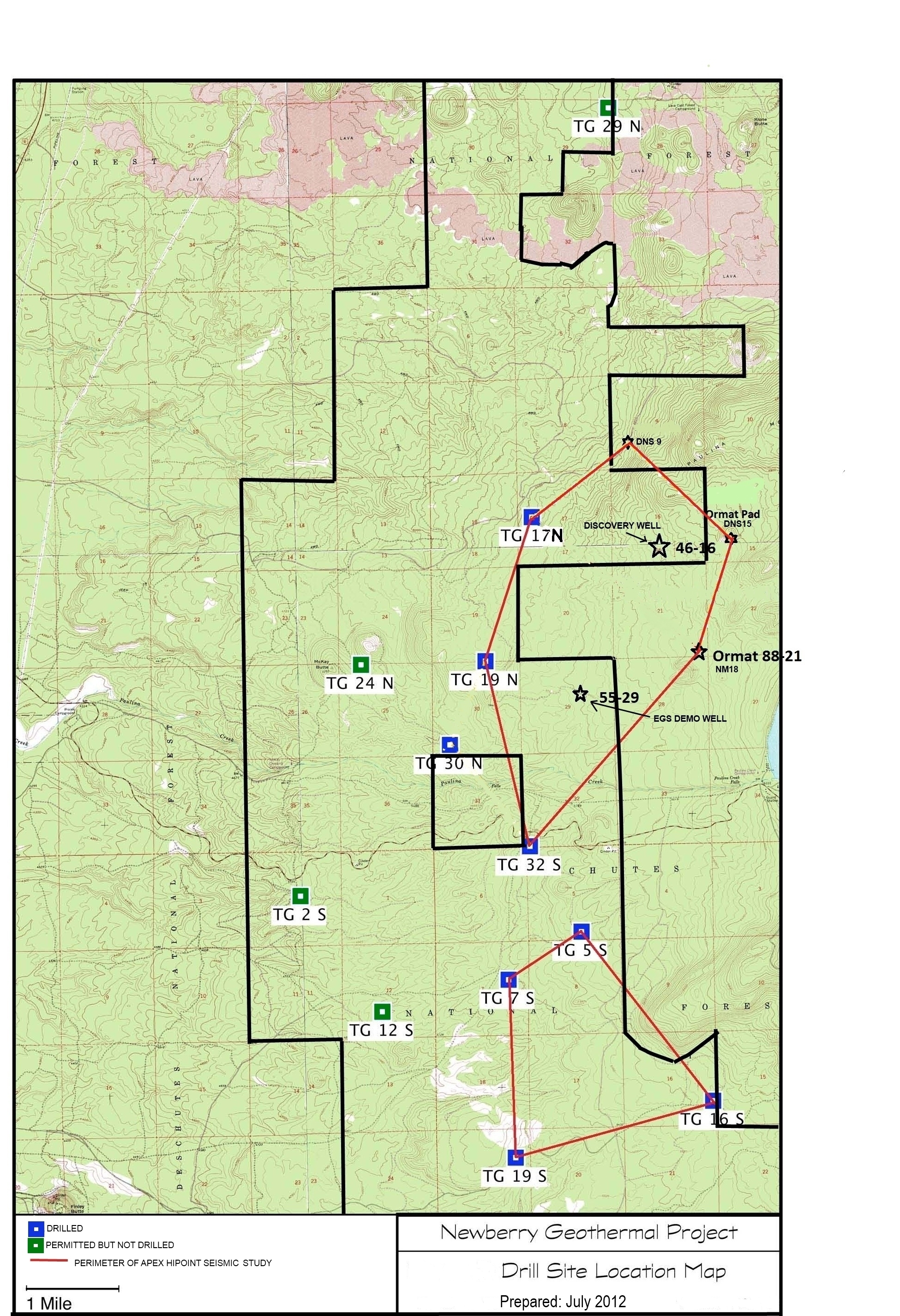
Federal
Map of Validation of Innovative Exploration Technologies for Newberry Volcano
Department of Energy —
A map showing location of wells permitted, drilled and seismic test, as part of validation of innovative exploration technologies done for the Newberry Volcano... -
Federal
TIGER/Line Shapefile, 2023, County, Rice County, KS, Feature Names Relationship File
U.S. Census Bureau, Department of Commerce —
The TIGER/Line shapefiles and related database files (.dbf) are an extract of selected geographic and cartographic information from the U.S. Census Bureau's Master... -
Federal
Mineral Commodity Summaries 2022 - SCANDIUM Data Release
Department of the Interior —
This data release contains the U.S. salient statistics and world production data extracted from the SCANDIUM data sheet of the USGS Mineral Commodity Summaries 2022.

Official websites use .gov
A
.gov website belongs to an official government
organization in the United States.
Secure .gov websites use HTTPS
A
lock (
) or https:// means you’ve safely connected to
the .gov website. Share sensitive information only on official,
secure websites.