
-
Federal
Defense Meteorological Satellite Program (DMSP) Film recent views
National Oceanic and Atmospheric Administration, Department of Commerce —
The United States Air Force Defense Meteorological Satellite Program (DMSP) Operational Linescan System (OLS) is a polar orbiting meteorological sensor with two... -
County
Allegheny County Kane Regional Center Census recent views
Allegheny County / City of Pittsburgh / Western PA Regional Data Center —
Total number of residents in each Kane Regional Center facility by race and gender. The Kane Regional Centers are skilled nursing and rehabilitation centers run by... -
Federal
Circa 1977 Land Area in Coastal Louisiana - Spatial Data - Landsat MSS recent views
Department of the Interior —
The dataset presented here represents a circa 1973 land/water delineation of coastal Louisiana used in part of a larger study to quantify landscape changes from 1932... -
State
Municipal Stormwater Permit Outfall Data recent views
State of Washington —
Special Condition S8.D of the 2007-2012 Phase I Municipal Stormwater Permit required permittees to collect and analyze data to evaluate pollutant loadings of... -
Federal
Long-term Crop Rotation Study for Greenhouse gas Reduction through Agricultural Carbon Enhancement network in Lincoln, Nebraska recent views
Department of Agriculture —
Long-term Crop Rotation Study for Greenhouse gas Reduction through Agricultural Carbon Enhancement network in Lincoln, Nebraska Lincoln NE Long-term Crop Rotation... -
Federal
Physics Based Electrolytic Capacitor Degradation Models for Prognostic Studies under Thermal Overstress recent views
National Aeronautics and Space Administration —
Electrolytic capacitors are used in several applications rang- ing from power supplies on safety critical avionics equipment to power drivers for electro-mechanical... -
Federal
CYGNSS Level 3 MRG Science Data Record Version 3.2.1 recent views
National Aeronautics and Space Administration —
This dataset contains the version 3.2.1 CYGNSS level 3 science data record merged storm (MRG) wind speed which combines CYGNSS storm-centric gridded (SCG) wind... -
Federal
Global Precipitation Climatology Project (GPCP) Climate Data Record (CDR), Version 2.3 (Monthly) recent views
National Oceanic and Atmospheric Administration, Department of Commerce —
The Global Precipitation Climatology Project (GPCP) consists of monthly satellite-gauge and associated precipitation error estimates and covers the period January... -
Federal
ru36-20220413T2107 recent views
National Oceanic and Atmospheric Administration, Department of Commerce —
This project is focused on collecting data for onboard glider processing from an Acoustic Doppler Current Profiler (ADCP). This is specifically targeted at collecting... -
Federal
BOREAS AFM-06 Boundary Layer Height Data recent views
National Aeronautics and Space Administration —
Contains AFM-06 hourly inversion height measurements. -
City
EMS - FY2015 Annual Report Infant Co-sleep recent views
City of Austin —
Static Data Set This table shows findings from Infant Academy survey conducted in FY2015 by the ATCEMS Community Relations section. It has been uploaded to support... -
Federal
Geologic provinces encompassing northern Afghanistan, 2006 (prvafg.shp) recent views
Department of the Interior —
This shapefile includes polygons that describe U.S. Geological Survey defined geologic provinces that encompass northern Afghanistan. -
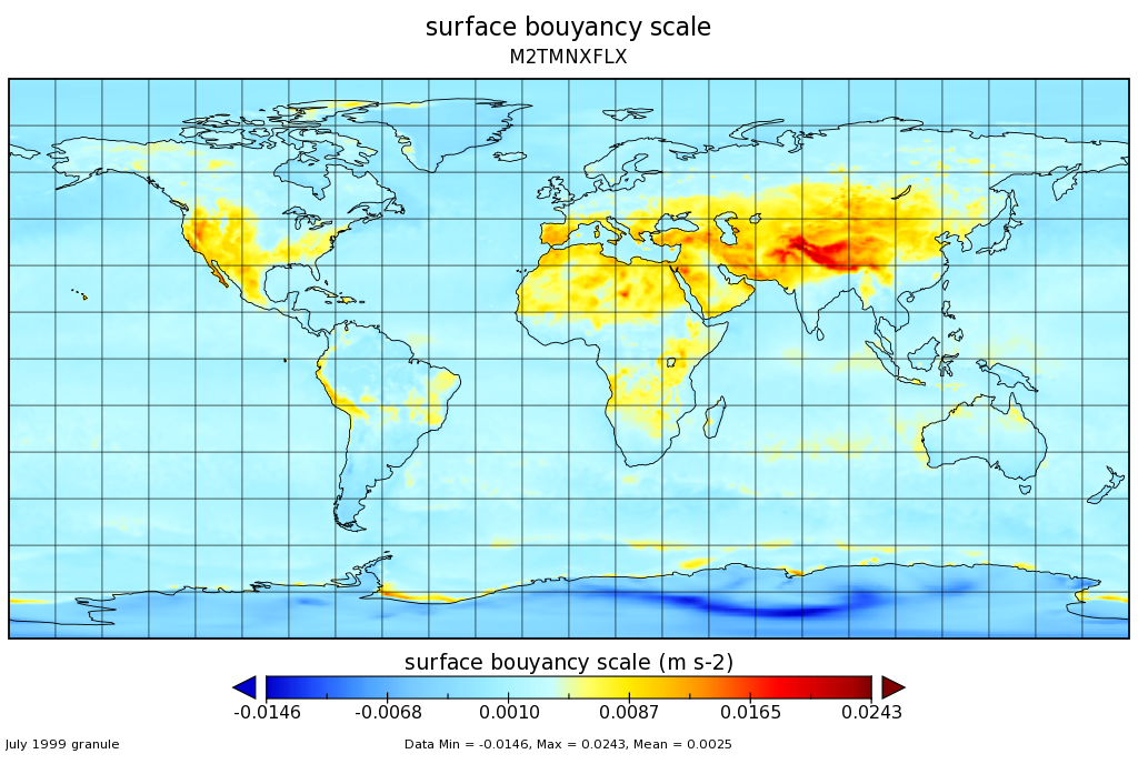
Federal
MERRA-2 tavgM_2d_flx_Nx: 2d,Monthly mean,Time-Averaged,Single-Level,Assimilation,Surface Flux Diagnostics 0.625 x 0.5 degree V5.12.4 (M2TMNXFLX) at GES DISC recent views
National Aeronautics and Space Administration —
M2TMNXFLX (or tavgM_2d_flx_Nx) is a time-averaged 2-dimensional monthly mean data collection in Modern-Era Retrospective analysis for Research and Applications... -
Federal
GRSM Travel Time Models recent views
Department of the Interior —
Great Smoky Mountains National Park Travel Time: This reference is for 3 travel time model rasters, with time from Park Headquarters, Twin Creeks Science Center, and... -
Federal
Coachella Valley fringe-toed lizard (Uma inornata) capture data (2017 and 2018) recent views
Department of the Interior —
This dataset includes location, field measurements, and descriptions of 330 Uma inornata sampled for the research study entitled “Sampling Across 20 Years (1996–2017)... -
Federal
Hillshade raster (235-degree azimuth, 20-degree sun angle) derived from lidar data collected after the August 24, 2014 South Napa Earthquake recent views
Department of the Interior —
Hillshade of lidar-derived, bare earth digital elevation model, with 235-degree azimuth and 20-degree sun angle, 0.25m resolution, depicting earthquake effects... -
Federal
Yield Editor 2.0.7 recent views
Department of Agriculture —
Yield Editor is a tool which allows the user to select, apply and analyze a variety of automated filters and editing techniques used to process and clean yield data.... -
Federal
2022 Cartographic Boundary File (KML), Current American Indian/Alaska Native/Native Hawaiian Areas for United States, 1:500,000 recent views
U.S. Census Bureau, Department of Commerce —
The 2022 cartographic boundary KMLs are simplified representations of selected geographic areas from the U.S. Census Bureau's Master Address File / Topologically... -
State
Counties' Net Other Postemployment Benefit Asset and Liability for Fiscal Years 2020-21 to 2021-22 recent views
State of California —
Net Other Postemployment Benefit (OPEB) Asset is the amount in excess of the amount owed to a defined benefit OPEB plan based on the actuarial present value (or other... -
Federal
Sea Level Rise: American Samoa: Extreme High-Tide Flooding: 2030 High Scenario: 50 Days Per Year recent views
National Oceanic and Atmospheric Administration, Department of Commerce —
This extreme high-tide flooding layer provides a prediction of future sea level rise (SLR) inundation and was produced using a passive flooding model, often referred...

Official websites use .gov
A
.gov website belongs to an official government
organization in the United States.
Secure .gov websites use HTTPS
A
lock (
) or https:// means you’ve safely connected to
the .gov website. Share sensitive information only on official,
secure websites.