
-
Federal
China Dimensions Data Collection: China County-Level Data from Provincial Economic Yearbooks, Keyed to 1:1M GIS Map
National Aeronautics and Space Administration —
The China County-Level Data on Provincial Economic Yearbooks, Keyed To 1:1M GIS Map consists of socioeconomic and boundary data for the administrative regions of... -
Federal
Proton irradiation augments the reduction in tumor progression observed with advanced age
National Aeronautics and Space Administration —
Proton irradiation is touted for its improved tumor targeting due to the physical advantages of ion beams for radiotherapy. Recent studies from our laboratory have... -
Federal
The Role of PTHrP in Osteoblast Response to Microgravity: Implications for Osteoporosis Development.
National Aeronautics and Space Administration —
Prolonged skeletal unloading through bedrest results in bone loss similar to that observed in elderly osteoporotic patients but with an accelerated timeframe. This... -
Federal
West Africa Coastal Vulnerability Mapping: Social Vulnerability Indices
National Aeronautics and Space Administration —
The West Africa Coastal Vulnerability Mapping: Social Vulnerability Indices data set includes three indices: Social Vulnerability, Population Exposure, and Poverty... -
Federal
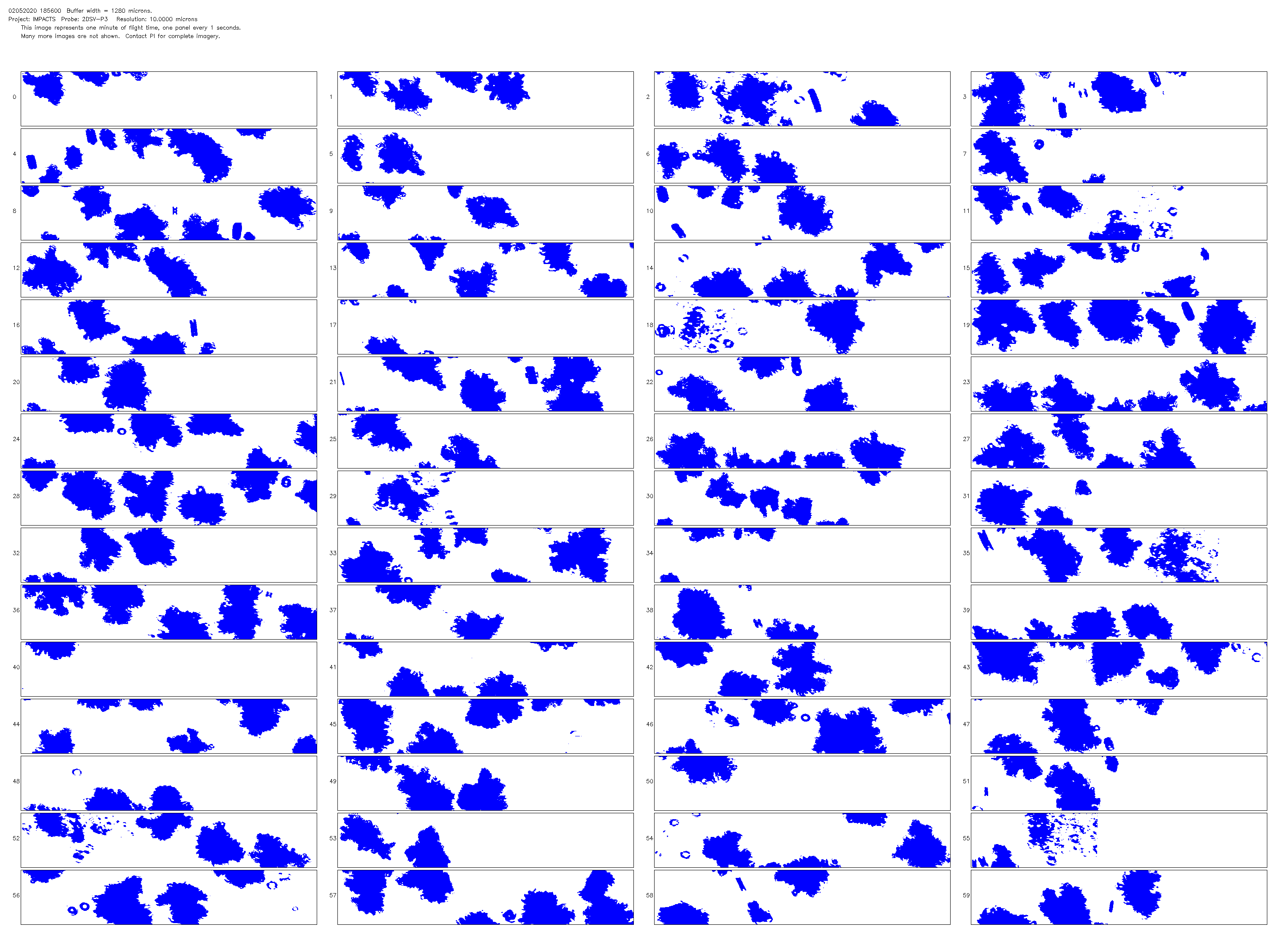
NCAR Particle Probes IMPACTS V1
National Aeronautics and Space Administration —
The NCAR Particle Probes IMPACTS dataset consists of data collected from six instruments on the NASA P-3 aircraft, the SPEC Hawkeye Cloud Particle Imager (CPI), the... -
Federal
SnowEx23 CRREL Ground Penetrating Radar V001
National Aeronautics and Space Administration —
This data set contains the results of 1 GHz ground-penetrating radar surveys conducted in Alaska, USA as part of the NASA SnowEx 2023 field campaign. The study site... -
Federal
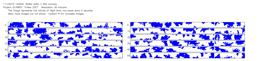
GPM Ground Validation NCAR Particle Probes OLYMPEX V1
National Aeronautics and Space Administration —
The GPM Ground Validation NCAR Particle Probes OLYMPEX dataset consists of ice water content, particle concentration normalized by bin width, and total particle... -
Federal
SnowEx20 Grand Mesa IOP BSU 1 GHz Multi-polarization GPR CMP Snow Water Equivalent V001
National Aeronautics and Space Administration —
This data set was collected during the SnowEx 2020 Intensive Observation Period (IOP) in Grand Mesa, Colorado. These data contain snow water equivalent (SWE)... -
Federal
CDDIS_GNSS_highrate_data
National Aeronautics and Space Administration —
Global Navigation Satellite System (GNSS) data consists of the U.S. Global Positioning System (GPS) and the Russian GLObal NAvigation Satellite System (GLONASS) (plus... -
Federal
Mouse fecal microbiome after exposure to high LET radiation
National Aeronautics and Space Administration —
Space travel is associated with continuous low-dose-rate exposure to high Linear Energy Transfer (LET) radiation. Pathophysiological manifestations after low-dose... -
Federal
Global Navigation Satellite System (GNSS) Satellite Data from NASA CDDIS
National Aeronautics and Space Administration —
Global Navigation Satellite System (GNSS) data consists of the U.S. Global Positioning System (GPS) and the Russian GLObal NAvigation Satellite System (GLONASS) (plus... -
Federal
ABoVE: Environmental Conditions and Subsistence Resource Access, Alaska, 2016-2017
National Aeronautics and Space Administration —
This dataset provides descriptions and photos of environmental conditions that impacted availability to subsistence resources by residents in nine rural communities... -
Federal
AWI Moored ULS Data, Greenland Sea and Fram Strait, 1991-2002, Version 1
National Aeronautics and Space Administration —
This data set consists of Upward Looking Sonar (ULS) data from 11 moorings in the Greenland Sea. Parameters in the processed data files include ice draft, water... -
Federal
CALIPSO Lidar Level 2 5 km Aerosol Layer Data, V4-21
National Aeronautics and Space Administration —
CAL_LID_L2_05kmALay-Standard-V4-21 is the Cloud-Aerosol Lidar and Infrared Pathfinder Satellite Observation (CALIPSO) Lidar Level 2 5 km Aerosol Layer Data, Version... -
Federal
CALIPSO Lidar Level 2 5 km Merged Layer, V4-51
National Aeronautics and Space Administration —
CAL_LID_L2_05kmMLay-Standard-V4-51 is the Cloud-Aerosol Lidar and Infrared Pathfinder Satellite Observation (CALIPSO) Lidar Level 2 5 km Merged (cloud + aerosol)... -
Federal
T Cell Activation in Microgravity Compared to 1g (Earth s) Gravity
National Aeronautics and Space Administration —
This study tested the hypothesis that transcription of immediate early genes is inhibited in T cells activated in microgravity (uG). Immunosuppression during... -
Federal
SnowEx21 Cameron Pass Ground Penetrating Radar V001
National Aeronautics and Space Administration —
This data set contains the results of 1 GHz ground-penetrating radar surveys conducted at Cameron Pass, Colorado during the SnowEx21 campaign. Data include two-way... -
Federal
miRNA signature detection and countermeasures against HZE radiation exposure for tissue degeneration-Plasma
National Aeronautics and Space Administration —
Biological risks associated with space radiation and microgravity are major concerns for long-term space travel. Through a Systems Biology approach our previous NASA... -
Federal
The Role of PTHrP in Osteoblast Response to Microgravity: Implications for Osteoporosis Development.
National Aeronautics and Space Administration —
Prolonged skeletal unloading through bedrest results in bone loss similar to that observed in elderly osteoporotic patients but with an accelerated timeframe. This...

Official websites use .gov
A
.gov website belongs to an official government
organization in the United States.
Secure .gov websites use HTTPS
A
lock (
) or https:// means you’ve safely connected to
the .gov website. Share sensitive information only on official,
secure websites.