
-
Federal
SDG Indicator 11.2.1: Urban Access to Public Transport, 2023 Release recent views
National Aeronautics and Space Administration —
The SDG Indicator 11.2.1: Urban Access to Public Transport, 2023 Release, part of the SDGI collection, measures the proportion of the population in a city that has... -
Federal
ASTER Orthorectified Digital Elevation Model (DEM) V003 NGDA recent views
National Aeronautics and Space Administration —
The ASTER Digital Elevation Model and Orthorectified Registered Radiance at the Sensor (AST14DMO) product... -
Federal
Global Database of Light-based Geospatial Income Inequality (LGII) Measures, Version 1 recent views
National Aeronautics and Space Administration —
The Global Database of Light-based Geospatial Income Inequality (LGII) Measures, Version 1 data set contains Gini-coefficients of inequality for 234 countries and... -
Federal
SWOT Level 2 Nadir Altimeter Interim Geophysical Data Record with Waveforms - GDR Version 1.0 recent views
National Aeronautics and Space Administration —
Same as L2_NALT_GDR, using preliminary values for some auxiliary data. Uses Medium-accuracy (preliminary) Orbit Ephemeris (MOE). Available with latency of < 1.5... -
Federal
RSS SMAP Level 3 Sea Surface Salinity Standard Mapped Image Monthly V6.0 Validated Dataset recent views
National Aeronautics and Space Administration —
The RSS SMAP Level 3 Sea Surface Salinity Standard Mapped Image Monthly V6.0 Validated Dataset produced by the Remote Sensing Systems (RSS) and sponsored by the NASA... -
Federal
SWOT Level 2 Nadir Altimeter Interim Geophysical Data Record with Waveforms Version 1.0 recent views
National Aeronautics and Space Administration —
The SWOT Level 2 Nadir Altimeter Interim Geophysical Data Record (IGDR) Version 1.0 dataset produced by the Surface Water and Ocean Topography (SWOT) mission provides... -
Federal
Global Rural-Urban Mapping Project, Version 1 (GRUMPv1): Settlement Points, Revision 01 recent views
National Aeronautics and Space Administration —
The Global Rural-Urban Mapping Project, Version 1 (GRUMPv1): Settlement Points, Revision 01 is an updated version of the Settlement Points, Version 1 (v1) used in the... -
Federal
Global Vegetation Height Metrics from GEDI and ICESat2 recent views
National Aeronautics and Space Administration —
This dataset provides global rasters of relative height metrics for vegetation from Global Ecosystem Dynamics Investigation (GEDI) L2A data and Ice, Cloud, and Land... -
Federal
Global Rural-Urban Mapping Project, Version 1 (GRUMPv1): Urban Extents Grid recent views
National Aeronautics and Space Administration —
The Global Rural-Urban Mapping Project, Version 1 (GRUMPv1): Urban Extents Grid distinguishes urban and rural areas based on a combination of population counts... -
Federal
OCO-3 Level 1B calibrated, geolocated calibration spectra, V10 (OCO3_L1B_Calibration) at GES DISC recent views
National Aeronautics and Space Administration —
Version 10 is the current version of the data set. Older versions will no longer be available and are superseded by Version 10. The Orbiting Carbon Observatory -3... -
Federal
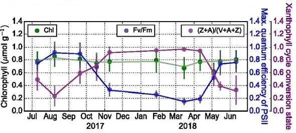
Conifer Needle Chlorophyll Fluorescence, Niwot Ridge, Colorado, USA, 2017-2018 recent views
National Aeronautics and Space Administration —
This dataset provides chlorophyll fluorescence measurements made on pine and spruce needle tissues at the Niwot Ridge AmeriFlux Core site (US-NR1) near Nederland,... -
Federal
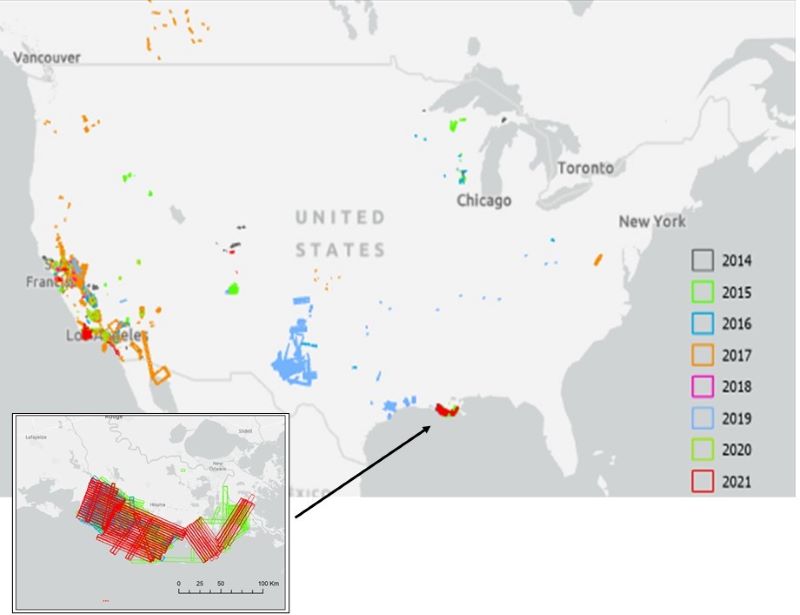
AVIRIS Facility Instruments: Flight Line Geospatial and Contextual Data recent views
National Aeronautics and Space Administration —
This dataset provides attributed geospatial and tabular information for identifying and querying flight lines of interest for the Airborne Visible InfraRed Imaging... -
Federal
Daily 8-Hour Maximum and Annual O3 Concentrations for the Contiguous United States, 1-km Grids, Version 1.10 (2000-2016) recent views
National Aeronautics and Space Administration —
The Daily 8-Hour Maximum and Annual O3 Concentrations for the Contiguous United States, 1-km Grids, Version 1.10 (2000-2016) data set contains estimates of ozone... -
Federal
GHRSST Level 2P NAVO 1 m Depth Global Sea Surface Temperature version 3.0 from the Visible Infrared Imaging Radiometer Suite (VIIRS) on the NOAA-21 satellite recent views
National Aeronautics and Space Administration —
The VIIRS_N21-NAVO-L2P-v3.0 dataset produced by the Naval Oceanographic Office (NAVO) derives the 1-meter depth Sea Surface Temperature (SST) from the Visible... -
Federal
Gridded GEDI Vegetation Structure Metrics and Biomass Density at Multiple Resolutions recent views
National Aeronautics and Space Administration —
This dataset consists of near-global, analysis-ready, multi-resolution gridded vegetation structure metrics derived from NASA Global Ecosystem Dynamics Investigation... -
Federal
Global Multihazard Frequency and Distribution recent views
National Aeronautics and Space Administration —
The Global Multihazard Frequency and Distribution is a 2.5 minute grid presenting a simple multihazard index based solely on summated single-hazard decile values. The... -
Federal
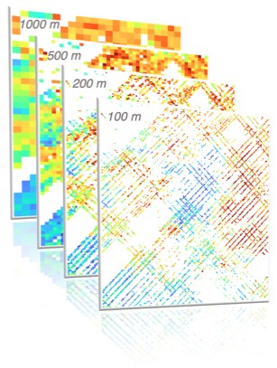
MASTER: Wildfire and farmland mapping, California, July, 2004 recent views
National Aeronautics and Space Administration —
This dataset includes Level 1B (L1B) and Level 2 (L2) data products from the MODIS/ASTER Airborne Simulator (MASTER) instrument. The spectral data were collected... -
Federal
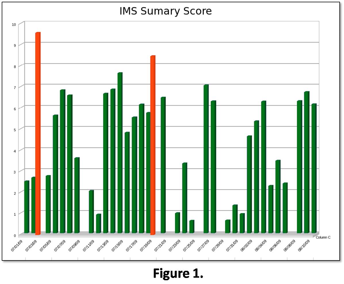
Integrated Building Health Management recent views
National Aeronautics and Space Administration —
Abstract: Building health management is an important part in running an efficient and cost-effective building. Many problems in a building’s system can go undetected... -
Federal
ABoVE: Wetland Vegetation Classification for Peace-Athabasca Delta, Canada, 2019 recent views
National Aeronautics and Space Administration —
This dataset contains land cover classification focused on water and wetland vegetation communities over the Peace-Athabasca Delta, Canada. Four classification maps... -
Federal
Global 1-km Downscaled Population Base Year and Projection Grids Based on the Shared Socioeconomic Pathways, Revision 01 recent views
National Aeronautics and Space Administration —
The Global 1-km Downscaled Population Base Year and Projection Grids Based on the Shared Socioeconomic Pathways, Revision 01, data set consists of global urban,...

Official websites use .gov
A
.gov website belongs to an official government
organization in the United States.
Secure .gov websites use HTTPS
A
lock (
) or https:// means you’ve safely connected to
the .gov website. Share sensitive information only on official,
secure websites.