AVIRIS Facility Instruments: Flight Line Geospatial and Contextual Data
Access & Use Information
Downloads & Resources
-
Google Scholar search resultsHTML
Search results for publications that cite this dataset by its DOI.
-
Download this datasetHTML
This link allows direct data access via Earthdata login
-
View documentation related to this datasetHTML
ORNL DAAC Data Set Documentation
-
This dataset's landing pageHTML
Data set Landing Page DOI URL
-
View documentation related to this datasetPDF
AVIRIS Facility Instruments: Flight Line Geospatial and Contextual Data:...
-
Get a related visualizationJPEG
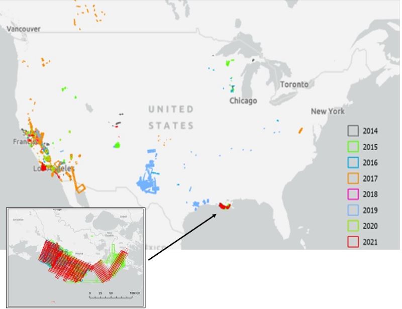
Location of AVIRIS-NG flight lines in the conterminous US for 2014 - 2021....
-
Landing PageLanding Page
Dates
| Metadata Created Date | April 27, 2023 |
|---|---|
| Metadata Updated Date | February 12, 2024 |
Metadata Source
- Data.json Data.json Metadata
Harvested from NASA Data.json
Graphic Preview

Additional Metadata
| Resource Type | Dataset |
|---|---|
| Metadata Created Date | April 27, 2023 |
| Metadata Updated Date | February 12, 2024 |
| Publisher | ORNL_DAAC |
| Maintainer | |
| Identifier | C2662360177-ORNL_CLOUD |
| Data First Published | 2024-02-02 |
| Language | en-US |
| Data Last Modified | 2024-02-06 |
| Category | AVIRIS, geospatial |
| Public Access Level | public |
| Bureau Code | 026:00 |
| Metadata Context | https://project-open-data.cio.gov/v1.1/schema/catalog.jsonld |
| Metadata Catalog ID | https://data.nasa.gov/data.json |
| Schema Version | https://project-open-data.cio.gov/v1.1/schema |
| Catalog Describedby | https://project-open-data.cio.gov/v1.1/schema/catalog.json |
| Citation | Green, R.O., P.G. Brodrick, J.W. Chapman, M. Eastwood, S. Geier, M. Helmlinger, S.R. Lundeen, W. Olson-Duvall, R. Pavlick, L.M. Rios, D.R. Thompson, and A.K. Thorpe. 2023. AVIRIS Facility Instruments: Flight Line Geospatial and Contextual Data. ORNL DAAC, Oak Ridge, Tennessee, USA. https://doi.org/10.3334/ORNLDAAC/2140 |
| Graphic Preview Description | Location of AVIRIS-NG flight lines in the conterminous US for 2014 - 2021. Inset shows detail of flight lines in coastal Louisiana associated with the Delta-X project. |
| Graphic Preview File | https://daac.ornl.gov/AVIRIS/guides/AVIRIS_FlightLine_Locator_Fig1.jpg |
| Harvest Object Id | 402f3f2c-4809-4aec-8ea8-8966d01b8943 |
| Harvest Source Id | 58f92550-7a01-4f00-b1b2-8dc953bd598f |
| Harvest Source Title | NASA Data.json |
| Homepage URL | https://doi.org/10.3334/ORNLDAAC/2140 |
| Metadata Type | geospatial |
| Old Spatial | -171.85 9.2 118.95 84.36 |
| Program Code | 026:001 |
| Source Datajson Identifier | True |
| Source Hash | f213744277fa8d0d0198efa356658fcad5de24962d29616f1773c6015746e627 |
| Source Schema Version | 1.1 |
| Spatial | |
| Temporal | 2006-04-11T00:00:00Z/2022-11-03T23:59:59Z |
Didn't find what you're looking for? Suggest a dataset here.

