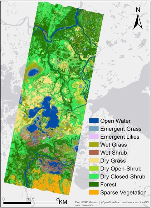
ABoVE: Wetland Vegetation Classification for Peace-Athabasca Delta, Canada, 2019
Access & Use Information
Downloads & Resources
-
Google Scholar search resultsHTML
Search results for publications that cite this dataset by its DOI.
-
Download this datasetHTML
This link allows direct data access via Earthdata login
-
View documentation related to this datasetHTML
ORNL DAAC Data Set Documentation
-
This dataset's landing pageHTML
Data set Landing Page DOI URL
-
View documentation related to this datasetPDF
ABoVE: Wetland Vegetation Classification for Peace-Athabasca Delta, Canada,...
-
Get a related visualizationJPEG
The wetland vegetation community classification for the Peace-Athabasca...
-
The dataset's project home pageHTML
ABoVE project site
-
Landing PageLanding Page
Dates
| Metadata Created Date | December 1, 2022 |
|---|---|
| Metadata Updated Date | December 6, 2023 |
Metadata Source
- Data.json Data.json Metadata
Harvested from NASA Data.json
Graphic Preview

Additional Metadata
| Resource Type | Dataset |
|---|---|
| Metadata Created Date | December 1, 2022 |
| Metadata Updated Date | December 6, 2023 |
| Publisher | ORNL_DAAC |
| Maintainer | |
| Identifier | C2308233855-ORNL_CLOUD |
| Data First Published | 2022-06-24 |
| Language | en-US |
| Data Last Modified | 2023-06-12 |
| Category | ABoVE, geospatial |
| Public Access Level | public |
| Bureau Code | 026:00 |
| Metadata Context | https://project-open-data.cio.gov/v1.1/schema/catalog.jsonld |
| Metadata Catalog ID | https://data.nasa.gov/data.json |
| Schema Version | https://project-open-data.cio.gov/v1.1/schema |
| Catalog Describedby | https://project-open-data.cio.gov/v1.1/schema/catalog.json |
| Citation | Wang, C., T.M. Pavelsky, E.D. Kyzivat, F. Garcia-Tigreros, F. Yao, X. Yang, S. Zhang, C. Song, T. Langhorst, W. Dolan, M. Kurek, M.E. Harlan, L.C. Smith, D. Butman, R.G.M. Spencer, C.J. Gleason, and D.L. Peters. 2022. ABoVE: Wetland Vegetation Classification for Peace-Athabasca Delta, Canada, 2019. ORNL DAAC, Oak Ridge, Tennessee, USA. https://doi.org/10.3334/ORNLDAAC/2069 |
| Graphic Preview Description | The wetland vegetation community classification for the Peace-Athabasca Delta, Alberta, Canada created from AVIRIS-NG derived features. |
| Graphic Preview File | https://daac.ornl.gov/ABOVE/guides/Wetland_VegClassification_PAD_Fig1.jpg |
| Harvest Object Id | 701b94e3-af90-4c86-b5cc-8e04f7a72d46 |
| Harvest Source Id | 58f92550-7a01-4f00-b1b2-8dc953bd598f |
| Harvest Source Title | NASA Data.json |
| Homepage URL | https://doi.org/10.3334/ORNLDAAC/2069 |
| Metadata Type | geospatial |
| Old Spatial | -112.11 58.21 -110.83 59.14 |
| Program Code | 026:001 |
| Source Datajson Identifier | True |
| Source Hash | e0596d8be35ba0bff2d93d3bba210e5f03a359de041fc2ea49b382a605fa0a4c |
| Source Schema Version | 1.1 |
| Spatial | |
| Temporal | 2019-07-15T00:00:00Z/2019-09-15T23:59:59Z |
Didn't find what you're looking for? Suggest a dataset here.

