
-
Federal
VIIRS/NPP Imagery Resolution Terrain-Corrected Geolocation 6-Min L1 Swath 375m NRT recent views
National Aeronautics and Space Administration —
The VIIRS/NPP Imagery Resolution Terrain-Corrected Geolocation 6-Min L1 Swath 375m Near Real Time (NRT) product, short-name VNP03IMG includes the geolocation fields... -
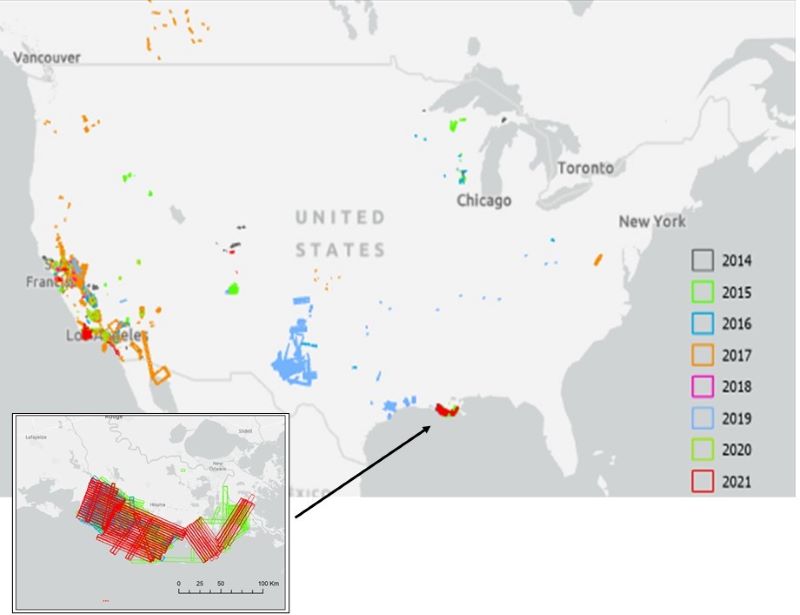
Federal
AVIRIS Facility Instruments: Flight Line Geospatial and Contextual Data recent views
National Aeronautics and Space Administration —
This dataset provides attributed geospatial and tabular information for identifying and querying flight lines of interest for the Airborne Visible InfraRed Imaging... -
Federal
ABLE-3B Electra Meteorological and Navigational Data recent views
National Aeronautics and Space Administration —
ABLE-3B Electra Meteorological and Navigational Data is the in-situ meteorological and navigational data collected onboard the NASA Electra aircraft during the Arctic... -
Federal
Sentinel-5P TROPOMI Radiance product band 1 (UV detector) L1B 5.5km x 21km V1 (S5P_L1B_RA_BD1_HiR) at GES DISC recent views
National Aeronautics and Space Administration —
Starting from August 6th in 2019, Sentinel-5P TROPOMI along-track high spatial resolution (~5.5km at nadir) has been implemented. For data before August 6th of 2019,... -
Federal
PEM Tropics B DC-8 Trajectory Data recent views
National Aeronautics and Space Administration —
PEM-Tropics-B_Trajectory_DC8_Data is the trajectory data collected along the DC-8 aircraft flight track during the Pacific Exploratory Mission (PEM) Tropics B... -
Federal
PEM Tropics A Satellite Data recent views
National Aeronautics and Space Administration —
PEM-Tropics-A_Satellite_Data is the satellite data collected during the Pacific Exploratory Mission (PEM) Tropics A suborbital campaign. Data from the Advanced Very... -
Federal
ABLE-2B Electra Meteorological and Navigational Data recent views
National Aeronautics and Space Administration —
ABLE-2B_MetNav_AircraftInSitu_Electra_Data is the in-situ meteorology and navigational data collected onboard the NASA Electra aircraft during the Amazon Boundary... -
Federal
SASS (Subsonics Assessment) Ozone and NOx Experiment (SONEX) DC-8 In-Situ Meteorological and Navigation Data recent views
National Aeronautics and Space Administration —
SONEX_TraceGas_AircraftInSitu_DC8_Data_1 is the in-situ meteorological and navigation data collected onboard the DC-8 aircraft during the SASS (Subsonics Assessment)... -
Federal
PEM Tropics A In-Situ P-3B Meteorology and Navigation Data recent views
National Aeronautics and Space Administration —
PEM-Tropics-A_MetNav_AircraftInSitu_P3B_Data is the in-situ meteorology and navigation data collected onboard the P-3B aircraft during the Pacific Exploratory Mission... -
Federal
ABLE-2A Electra Meteorological and Navigational Data recent views
National Aeronautics and Space Administration —
ABLE-2A_MetNav_AircraftInSitu_Electra_Data is the in-situ meteorology and navigational data collected onboard the NASA Electra aircraft during the Amazon Boundary... -
Federal
PEM West B In-Situ DC-8 Meteorology and Navigation Data recent views
National Aeronautics and Space Administration —
PEM-West-B_MetNav_AircraftInSitu_DC8_Data is the in situ meteorology and navigation data collected onboard the DC-8 aircraft during the Pacific Exploratory Mission... -
Federal
ABLE-3B Trajectory Data recent views
National Aeronautics and Space Administration —
ABLE-3B_Trajectory_Data is the trajectory data collected during the Arctic Boundary Layer Expedition - 3B (ABLE-3B) suborbital campaign. Data collection for this... -
Federal
PEM Tropics A Merge Data recent views
National Aeronautics and Space Administration —
PEM-Tropics-A_Merge_Data is the merge data collected during the Pacific Exploratory Mission (PEM) Tropics A suborbital campaign. Data collection for this product is... -
Federal
PEM West B Merge Data recent views
National Aeronautics and Space Administration —
PEM-West-B_Merge_Data is the merge data collected onboard the DC-8 aircraft during the Pacific Exploratory Mission (PEM) West B suborbital campaign. Data collection... -
Federal
PEM Tropics B P-3B Trajectory Data recent views
National Aeronautics and Space Administration —
PEM-Tropics-B_Trajectory_P3B_Data is the trajectory data collected onboard the P-3B aircraft during the Pacific Exploratory Mission (PEM) Tropics B suborbital... -
Federal
MISR Level 1A Navigation Data V002 recent views
National Aeronautics and Space Administration —
MI1ANAV_2 is the Multi-angle Imaging SpectroRadiometer (MISR) Level 1A Navigation Data version 2. This is the Reformatted Annotated Level 1A Product for the... -
Federal
PEM Tropics A In-Situ DC-8 Meteorology and Navigation Data recent views
National Aeronautics and Space Administration —
PEM-Tropics-A_MetNav_AircraftInSitu_DC8_Data is the in situ meteorology and navigation data collected onboard the DC-8 aircraft during the Pacific Exploratory Mission... -
Federal
PEM West A In-Situ DC-8 Meteorology and Navigation Data recent views
National Aeronautics and Space Administration —
PEM-West-A_MetNav_AircraftInSitu_DC8_Data is the in situ meteorology and navigation data collected onboard the DC-8 aircraft during the Pacific Exploratory Mission...

Official websites use .gov
A
.gov website belongs to an official government
organization in the United States.
Secure .gov websites use HTTPS
A
lock (
) or https:// means you’ve safely connected to
the .gov website. Share sensitive information only on official,
secure websites.