
-
Federal
OCO-3 Instrument Attitude and Ephemeris Data for One Specific Solar Day, Forward Processing V11 (OCO3_L1aAE) at GES DISC
National Aeronautics and Space Administration —
Version 11 is the current version of the data set. Older versions will no longer be available and are superseded by Version 11. The Orbiting Carbon Observatory is the... -
Federal
OMPS-N20 NM PCA SO2 Step 1 Total Column 1-Orbit L2 Swath 17x13km
National Aeronautics and Space Administration —
The OMPS-N20_NM_PCA_SO2 Step1 Total Column 1-Orbit L2 Swath 17x13km collection 1 product contains the retrieved sulfur dioxide (SO2) measured by the Ozone Mapping and... -
Federal
ESMR/Nimbus-5 Images of Brightness Temperature on 70 mm Film V001 (ESMRN5IM) at GES DISC
National Aeronautics and Space Administration —
ESMRN5IM is the Nimbus-5 Electrically Scanning Microwave Radiometer (ESMR) data product containing daily brightness temperature images from 70-mm photofacsimile film... -
Federal
TRMM Ground Validation Radar Site Rain Totals Map L3 5 days 2 km V7 (TRMM_3A53) at GES DISC
National Aeronautics and Space Administration —
This is the 5-day accumulation of the 2A53 product, 'Radar Site Rain Map', which originally is an instantaneous surface rain rate map in Cartesian coordinates with a... -
Federal
OCO-3 Level 1A collated, parsed, science or calibration data, Retrospective Processing V11r (OCO2_L1aIn_Sample) at GES DISC
National Aeronautics and Space Administration —
Version 11r is the current version of the data set. Older versions will no longer be available and are superseded by Version 11r. The Orbiting Carbon Observatory is... -
Federal
HRIR/Nimbus-1 Level 1 Meteorological Radiation Data V001 (HRIRN1L1) at GES DISC
National Aeronautics and Space Administration —
HRIRN1L1 is the High Resolution Infrared Radiometer (HRIR) Nimbus-1 Level 1 Meteorological Radiance Data (NMRT) product and contains infrared radiances converted to... -
Federal
TROPESS Chemical Reanalysis Ozone Spread Monthly 3-dimensional Product V1 (TRPSCRO3SM3D) at GES DISC
National Aeronautics and Space Administration —
The TROPESS Chemical Reanalysis O3 Spread Monthly 3-dimensional Product contains the ozone ensemble spread, a measure of data assimilation analysis uncertainty. The... -
Federal
OMI/Aura and MODIS/Aqua Merged Cloud Product 1-Orbit L2 Swath 13x24 km V003 (OMMYDCLD) at GES DISC NGDA
National Aeronautics and Space Administration —
The OMI/Aura and MODIS/Aqua Merged Cloud Product 1-Orbit L2 Swath 13x24 km (OMMYDCLD) is a Level-2 orbital product that combines cloud parameters retrieved by the... -
Federal
GPM DPR L2A Environment 1.5 hours 5 km V07 (GPM_2ADPRENV) at GES DISC
National Aeronautics and Space Administration —
Version 07 is the current version of the data set. Older versions will no longer be available and have been superseded by Version 07. . This is environmental data... -
Federal
MODIS/Aqua Clouds 1km and 5km 5-Min L2 Wide Swath Subset along CloudSat V002 (MAC06S1) at GES DISC NGDA
National Aeronautics and Space Administration —
This is the wide-swath MODIS/Aqua subset along CloudSat field of view track. The goal of the wide-swath subset is to select and return MODIS data that are within... -
Federal
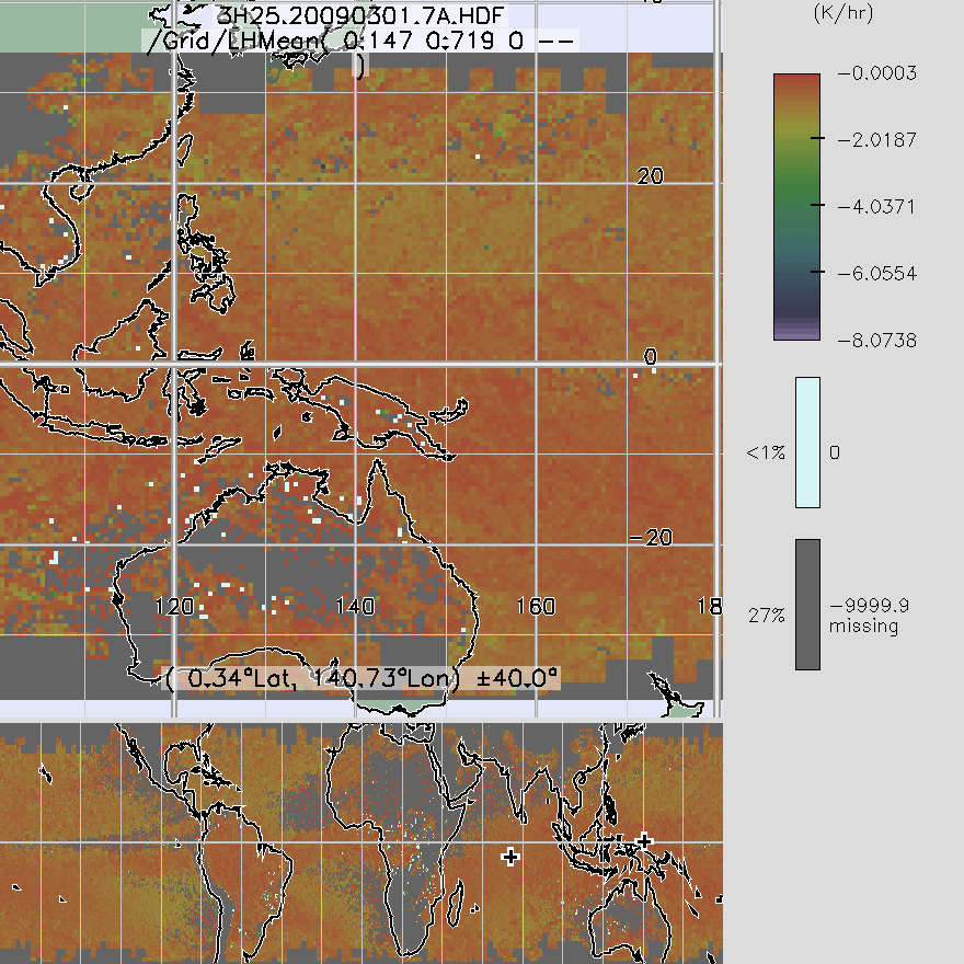
TRMM Precipitation Radar Spectral Latent Heating L3 1 month 0.5 degree x 0.5 degree V7 (TRMM_3H25) at GES DISC
National Aeronautics and Space Administration —
3H25, "Monthly Spectral Latent Heating", produces 0.5 degree x 0.5 degree latent heating, Q1-QR, and Q2 profiles from PR rain -
Federal
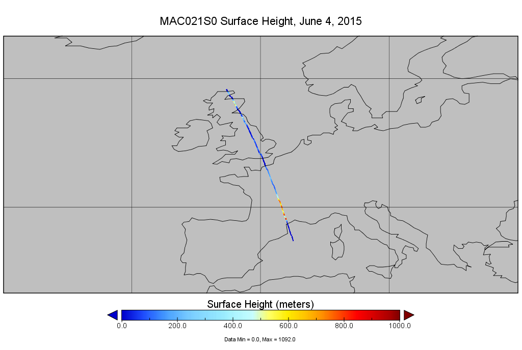
MODIS/Aqua Calibrated Radiances 1km 5-Min 1B Narrow Swath Subset along CloudSat V002 (MAC021S0) at GES DISC NGDA
National Aeronautics and Space Administration —
This is the narrow-swath MODIS/Aqua subset along CloudSat field of view track. The goal of the narrow-swath subset is to select and return MODIS data that are within... -
Federal
MODIS/Aqua Temp and Water Vapor Profile 5-Min L2 Swath Subset 5km subset along MLS V002 (MAM07S0) at GES DISC NGDA
National Aeronautics and Space Administration —
This is the MODIS/Aqua subset along MLS field of view track. The goal of the subset is to select and return MODIS data that are within +-100 km across the MLS track.... -
Federal
TRMM TMI/PR Combined Precipitation L3 1 month 0.5 degree x 0.5 degree V7 (TRMM_3B31) at GES DISC
National Aeronautics and Space Administration —
This is a combined rainfall product. 3B31 uses the high quality retrievals done for the narrow swath in 2B31 to calibrate the wide swath retrievals generated in 2A12.... -
Federal
SCR/Nimbus-4 Level 1 Calibrated Radiances V001 (SCRN4L1RAD) at GES DISC
National Aeronautics and Space Administration —
SCRN4L1RAD is the Nimbus-4 Selective Chopper Radiometer (SCR) Level 1 Calibrated Radiances data product. The calibrated radiances are measured at 6 channels from 2.3... -
Federal
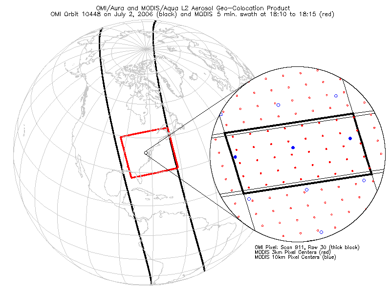
OMI/Aura and MODIS/Aqua Aerosol Geo-colocation Product 1-Orbit L2 Swath 13x24 km V003 (OMMYDAGEO) at GES DISC NGDA
National Aeronautics and Space Administration —
The OMI/Aura and MODIS/Aqua Aerosol Geo-colocation Product 1-Orbit L2 Swath 13x24 km (OMMYDAGEO) is a Level-2 orbital data product that links the MODIS/Aqua aerosol... -
Federal
UARS Solar Ultraviolet Spectral Irradiance Monitor (SUSIM) Level 3BS V022 (UARSU3BS) at GES DISC
National Aeronautics and Space Administration —
The Solar Ultraviolet Spectral Irradiance Monitor (SUSIM) Level 3BS data product consists of daily, 1 nm resolution, solar spectral irradiances and selected solar... -
Federal
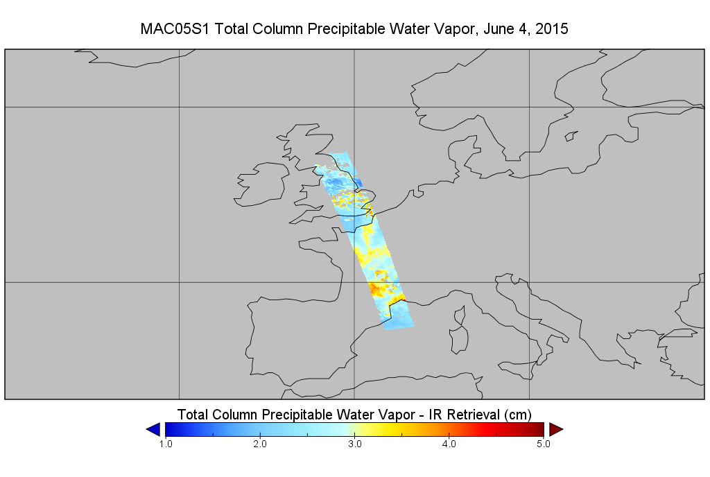
MODIS/Aqua Total Precip Water Vapor 1km and 5km 5-Min L2 Swath Subset along MLS V002 (MAM05S0) at GES DISC NGDA
National Aeronautics and Space Administration —
This is the MODIS/Aqua subset along MLS field of view track. The goal of the subset is to select and return MODIS data that are within +-100 km across the MLS track.... -
Federal
Legates Surface and Ship Observations of Precipitation Climatology 0.5 x 0.5 degree V1 (RAIN_LEGATES) at GES DISC
National Aeronautics and Space Administration —
The Legates Surface and Shipboard Rain Gauge Observations data set consists of a global climatology of monthly mean precipitation values. A global climatology of mean... -
Federal
TROPESS Chemical Reanalysis Ozone Monthly 3-dimensional Product V1 (TRPSCRO3M3D) at GES DISC
National Aeronautics and Space Administration —
The TROPESS Chemical Reanalysis O3 Monthly 3-dimensional Product contains vertical concentrations of ozone. The data are part of the Tropospheric Chemical Reanalysis...

Official websites use .gov
A
.gov website belongs to an official government
organization in the United States.
Secure .gov websites use HTTPS
A
lock (
) or https:// means you’ve safely connected to
the .gov website. Share sensitive information only on official,
secure websites.