
-
Federal
VISSR/GOES-1 Infrared Imagery on 70mm Film V001 (VISSRGOES1IMIR) at GES DISC
National Aeronautics and Space Administration —
VISSRGOES1IMIR is the Visible Infrared Spin-Scan Radiometer (VISSR) Infrared Imagery on 70mm Film data product from the first Geostationary Operational Environmental... -
Federal
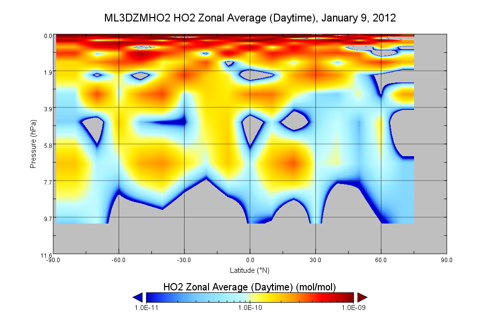
MLS/Aura Level 3 Hydroperoxy (HO2) Daily 10degrees Lat Zonal Mean V004 (ML3DZMHO2) at GES DISC
National Aeronautics and Space Administration —
ML3DZMHO2 is the EOS Aura Microwave Limb Sounder (MLS) daily zonal mean product for hydroperoxy derived from radiances measured in two bands from the 640 GHz... -
Federal
MERRA-2 instU_3d_asm_Np: 3d,diurnal,Instantaneous,Pressure-Level,Assimilation,Assimilated Meteorological Fields 0.625 x 0.5 degree V5.12.4 (M2IUNPASM) at GES DISC
National Aeronautics and Space Administration —
M2IUNPASM (or instU_3d_asm_Np) is an instantaneous 3-dimensional monthly diurnal means data collection in Modern-Era Retrospective analysis for Research and... -
Federal
GLDAS Noah Land Surface Model L4 monthly 0.25 x 0.25 degree V2.1 (GLDAS_NOAH025_M) at GES DISC
National Aeronautics and Space Administration —
NASA Global Land Data Assimilation System Version 2 (GLDAS-2) has three components: GLDAS-2.0, GLDAS-2.1, and GLDAS-2.2. GLDAS-2.0 is forced entirely with the... -
Federal
NLDAS Secondary Forcing Data L4 Hourly 0.125 x 0.125 degree V2.0 (NLDAS_FORB0125_H) at GES DISC
National Aeronautics and Space Administration —
This data set contains the secondary forcing hourly data "File B" for Phase 2 of the North American Land Data Assimilation System (NLDAS-2). The data are in 1/8th... -
Federal
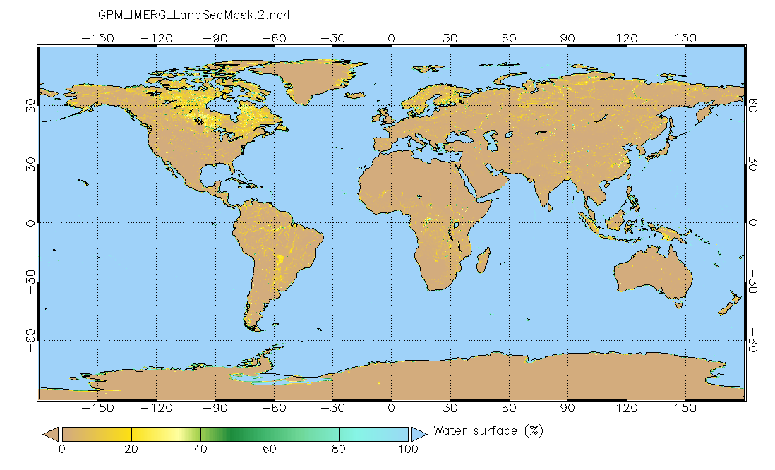
Land/Sea static mask relevant to IMERG precipitation 0.1x0.1 degree V2 (GPM_IMERG_LandSeaMask) at GES DISC
National Aeronautics and Space Administration —
Version 2 is the current version of the data set. Older versions will no longer be available and have been superseded by Version 2. This land sea mask originated from... -
Federal
HAQAST Sentinel-5P TROPOMI Nitrogen Dioxide (NO2) CONUS Monthly Level 3 0.01 x 0.01 Degree Gridded Data V2.4 (HAQ_TROPOMI_NO2_CONUS_M_L3) at GES DISC
National Aeronautics and Space Administration —
This product provides level 3 annual averages of tropospheric Nitrogen dioxide (NO2) vertical column density derived from the level 2 Tropospheric Monitoring... -
Federal
GLDAS VIC Land Surface Model L4 monthly 1.0 x 1.0 degree Early Product V2.1 (GLDAS_VIC10_M_EP) at GES DISC
National Aeronautics and Space Administration —
NASA Global Land Data Assimilation System Version 2 (GLDAS-2) has three components: GLDAS-2.0, GLDAS-2.1, and GLDAS-2.2. GLDAS-2.0 is forced entirely with the... -
Federal
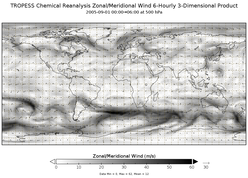
TROPESS Chemical Reanalysis Zonal Wind 6-Hourly 3-dimensional Product V1 (TRPSCRU6H3D) at GES DISC
National Aeronautics and Space Administration —
The TROPESS Chemical Reanalysis Zonal Wind 6-Hourly 3-dimensional Product contains vertical zonal wind component (u vector) values, a meteorological field. The data... -
Federal
Sentinel-5P TROPOMI Total Ozone Column 1-Orbit L2 7km x 3.5km V1 (S5P_L2__O3_TOT) at GES DISC
National Aeronautics and Space Administration —
Starting from August 6th in 2019, Sentinel-5P TROPOMI along-track high spatial resolution (~5.5km at nadir) has been implemented. Starting from July 13th in 2020,... -
Federal
MERRA-2 inst1_2d_asm_Nx: 2d,1-Hourly,Instantaneous,Single-Level,Assimilation,Single-Level Diagnostics 0.625 x 0.5 degree V5.12.4 (M2I1NXASM) at GES DISC
National Aeronautics and Space Administration —
M2I1NXASM (or inst1_2d_asm_Nx) is an instantaneous 2-dimensional hourly data collection in Modern-Era Retrospective analysis for Research and Applications version 2... -
Federal
OMI/Aura Formaldehyde (HCHO) Total Column Daily L3 Weighted Mean Global 0.1deg Lat/Lon Grid V003 (OMHCHOd) at GES DISC
National Aeronautics and Space Administration —
The OMI/Aura Formaldehyde (HCHO) Total Column Daily L3 Weighted Mean Global 0.1deg Lat/Lon Grid (OMHCHOd). The formaldehyde values in each file are the average for... -
Federal
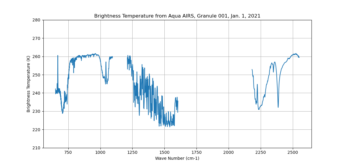
AIRS/Aqua L1B Infrared (IR) geolocated and calibrated radiances V005 (AIRIBRAD) at GES DISC at GES DISC
National Aeronautics and Space Administration —
WARNING: On 2021/09/23 the EOS Aqua executed a Deep Space Maneuver (DSM). In the DSM, the spacecraft is turned such that the normal Earth field of regard is deep... -
Federal
Sounder SIPS: Sun Synchronous 13:30 orbit Climate Hyperspectral InfraRed Product (CHIRP): Calibrated Radiances from EOS-Aqua, V2 (SNDR13CHRP1AQCal) at GES DISC
National Aeronautics and Space Administration —
The Climate Hyperspectral Infrared Radiance Product (CHIRP) is a Level 1 radiance product derived from Atmospheric Infrared Sounder (AIRS) on EOS-AQUA and the Cross-... -
Federal
MERRA-2 tavg1_2d_aer_Nx: 2d,1-Hourly,Time-averaged,Single-Level,Assimilation,Aerosol Diagnostics 0.625 x 0.5 degree V5.12.4 (M2T1NXAER) at GES DISC
National Aeronautics and Space Administration —
M2T1NXAER (or tavg1_2d_aer_Nx) is an hourly time-averaged 2-dimensional data collection in Modern-Era Retrospective analysis for Research and Applications version 2... -
Federal
AIRS/Aqua L1B Near Real Time (NRT) Infrared (IR) geolocated and calibrated radiances V005 (AIRIBRAD_NRT) at GES DISC
National Aeronautics and Space Administration —
WARNING: On 2021/09/23 the EOS Aqua executed a Deep Space Maneuver (DSM). In the DSM, the spacecraft is turned such that the normal Earth field of regard is deep... -
Federal
IRIS/Nimbus-4 Level 1 Radiance Data V001 (IRISN4RAD) at GES DISC
National Aeronautics and Space Administration —
The Nimbus-4 Infrared Interferometer Spectrometer (IRIS) Level 1 Radiance Data contain thermal emissions of the Earth's atmosphere at wave numbers between 400 and... -
Federal
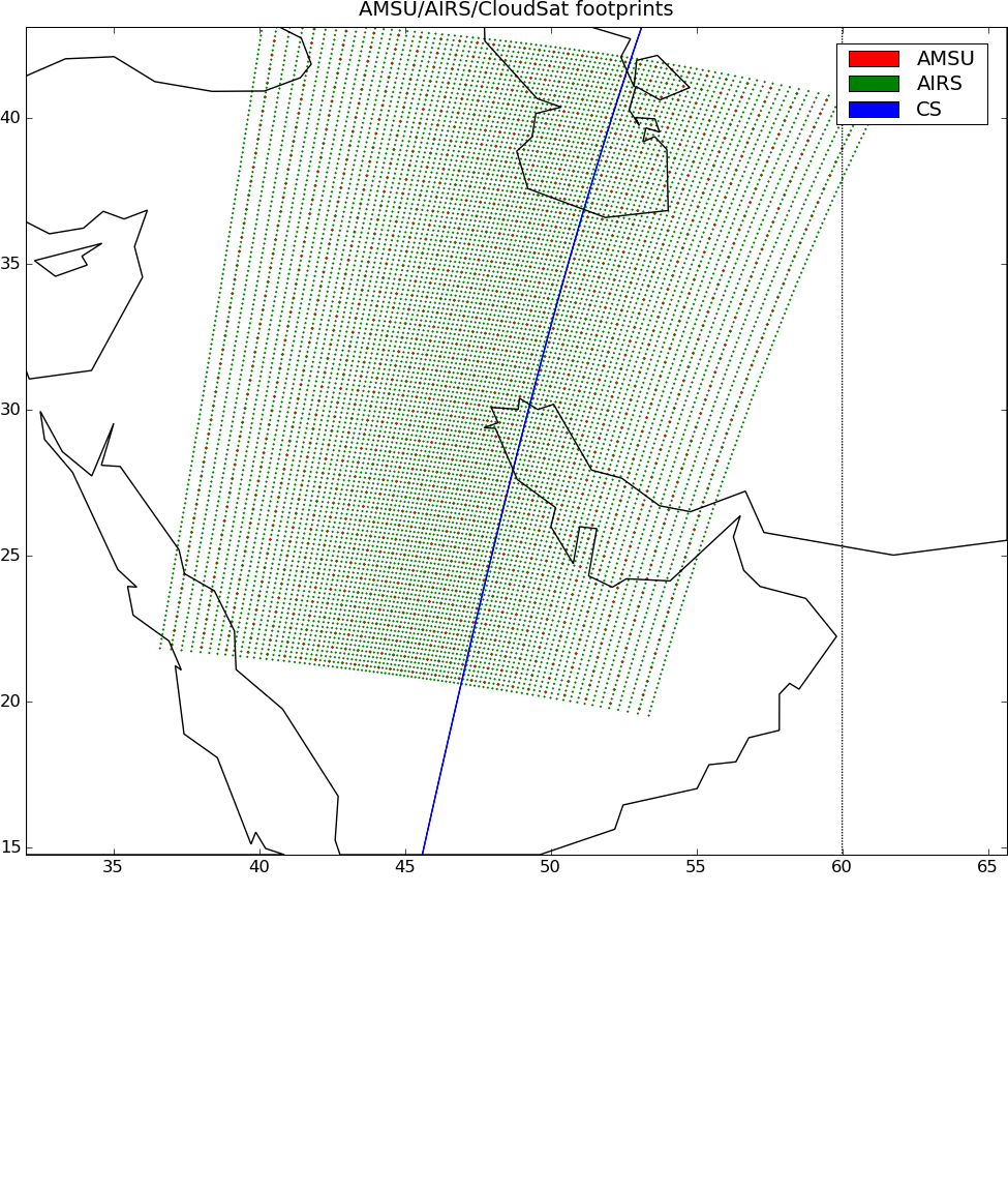
AIRS-CloudSat cloud mask, radar reflectivities, and cloud classification matchups V3.2 (AIRS_CPR_MAT) at GES DISC
National Aeronautics and Space Administration —
This is AIRS-CloudSat collocated subset, in NetCDF-4 format. These data contain collocated: AIRS Level 1b radiances spectra, CloudSat radar reflectivities, and MODIS... -
Federal
Carbon Monitoring System Carbon Flux FossilFuel Prior L4 V3 (CMSFluxFossilFuelPrior)
National Aeronautics and Space Administration —
This dataset provides the Prior for the Fossil Fuel Carbon Flux. The NASA Carbon Monitoring System (CMS) is designed to make significant contributions in... -
Federal
MLS/Aura Level 3 Daily Binned Cloud Ice (IWC) on Assorted Grids V005 (ML3DBIWC) at GES DISC
National Aeronautics and Space Administration —
ML3DBIWC is the EOS Aura Microwave Limb Sounder (MLS) daily binned on various vertical grids product for cloud ice water content (IWC) derived from radiances measured...

Official websites use .gov
A
.gov website belongs to an official government
organization in the United States.
Secure .gov websites use HTTPS
A
lock (
) or https:// means you’ve safely connected to
the .gov website. Share sensitive information only on official,
secure websites.