
-
Federal
Aviation Safety Reporting System: Penetration of Prohibited Airspace
National Aeronautics and Space Administration —
A sampling of reports involving TFR and ADIZ incidents. -
Federal
Real System Failures
National Aeronautics and Space Administration —
This resource area contains descriptions of actual electronic systems failure scenarios with an emphasis on the diversity of failure modes and effects that can befall... -
Federal
CAMEX-3 DC-8 NAVIGATION (DADS) DATA V1
National Aeronautics and Space Administration —
The CAMEX-3 DC-8 Navigation Data Acquisition and Distribution System (DADS) data files contain information recorded by navigation and data collection systems onboard... -
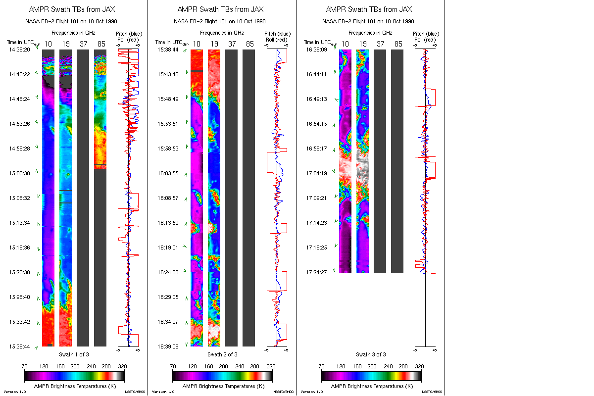
Federal
AMPR JACKSONVILLE BRIGHTNESS TEMPERATURE (TB) V2
National Aeronautics and Space Administration —
The Advanced Microwave Precipitation Radiometer (AMPR) was deployed in Jacksonville, FL for the initial AMPR instrument validation. AMPR data were collected at four... -
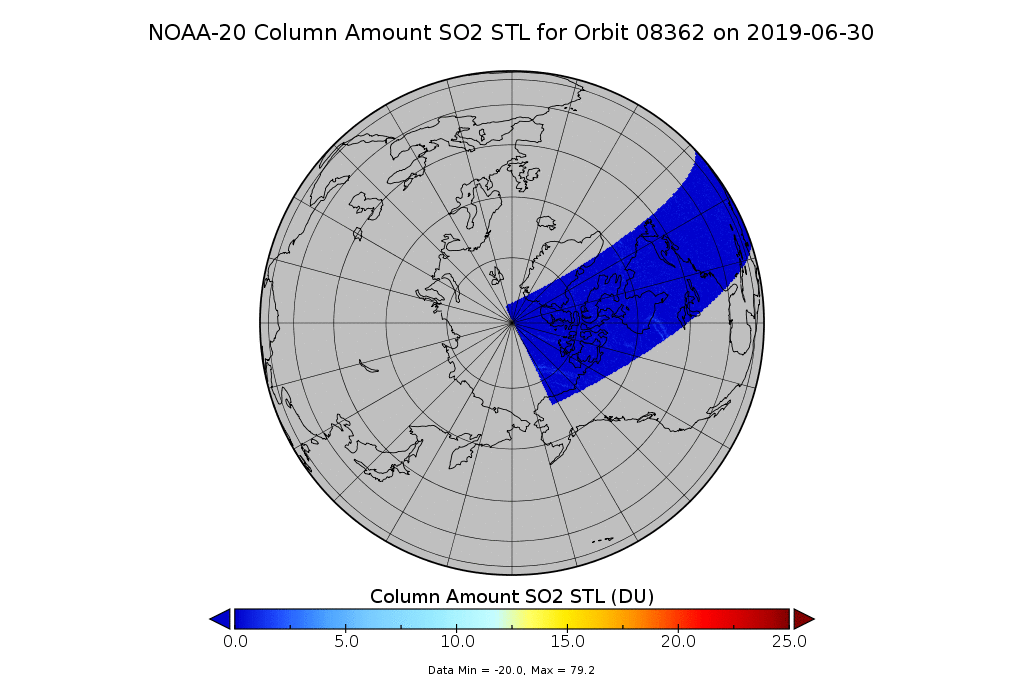
Federal
OMPS-N20 NM PCA SO2 Step 1 Total Column 1-Orbit L2 Swath 17x13km
National Aeronautics and Space Administration —
The OMPS-N20_NM_PCA_SO2 Step1 Total Column 1-Orbit L2 Swath 17x13km collection 1 product contains the retrieved sulfur dioxide (SO2) measured by the Ozone Mapping and... -
Federal
Simulating Degradation Data for Prognostic Algorithm Development
National Aeronautics and Space Administration —
PHM08 Challenge Dataset is now publicly available at the NASA Prognostics Respository +- BMP
- GIF
- BMP
- BMP
FederalImages
National Aeronautics and Space Administration —
Images for the website main pages and all configurations. The upload and access points for the other images are: Website Template RSW images BSCW Images HIRENASD ImagesFederalGOES-R PLT Cloud Physics LiDAR (CPL) V1
National Aeronautics and Space Administration —
The GOES-R PLT Cloud Physics Lidar (CPL) dataset consists of backscatter coefficient, lidar depolarization ratio, layer top/base height, layer type, particulate...FederalAMPR FIRE III ACE V1
National Aeronautics and Space Administration —
The Advanced Microwave Precipitation Radiometer (AMPR) was deployed during the First ISCCP Regional Experiment-III Arctic Cloud Experiment (FIRE-III/ACE). AMPR data...FederalGPM Ground Validation CXSI Radar Imagery OLYMPEX V1
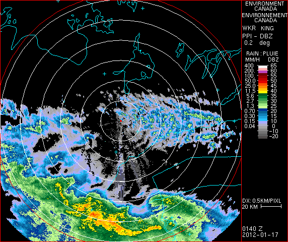
National Aeronautics and Space Administration —
The GPM Ground Validation CXSI Radar Imagery OLYMPEX dataset contains radar reflectivity and precipitation rate images obtained from Environment and Climate Change...FederalUARS Solar-Stellar Irradiance Comparison Experiment (SOLSTICE) Level 3BS V018 (UARSO3BS) at GES DISC
National Aeronautics and Space Administration —
The Solar-Stellar Irradiance Comparison Experiment (SOLSTICE) Level 3BS data product consists of daily, 1 nm resolution, solar spectral irradiances and selected solar...FederalCAMEX-3 LiDAR Atmospheric Sensing Experiment (LASE) Imagery V1
National Aeronautics and Space Administration —
The CAMEX-3 LiDAR Atmospheric Sensing Experiment (LASE) Imagery dataset is a browse-only dataset that consists of plotted reflectivity data collected by the LiDAR...FederalGPM GROUND VALIDATION DUAL POLARIZED C-BAND DOPPLER RADAR KING CITY GCPEX V1
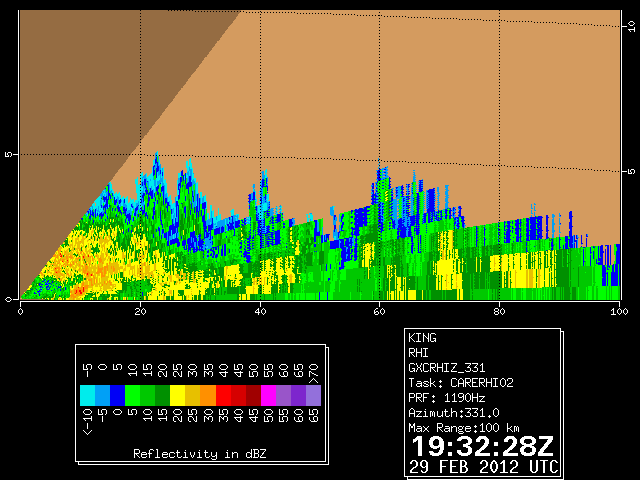
National Aeronautics and Space Administration —
The GPM Ground Validation Dual Polarized C-Band Doppler Radar King City GCPEx dataset has special Range Height Indicator (RHI) and sector scans of several dual...FederalRecurring Anomaly Detection System (ReADS)
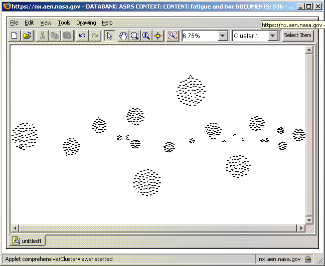
National Aeronautics and Space Administration —
Overview: ReADS can analyze text reports, such as aviation reports and problem or maintenance records. ReADS uses text clustering algorithms to group loosely related...FederalAMPR BRIGHTNESS TEMPERATURE CAMEX-1 V2
National Aeronautics and Space Administration —
The Advanced Microwave Precipitation Radiometer (AMPR) was deployed during the Convection and Moisture Experiments (CAMEX-1) conducted at Wallops Island, VA. AMPR...Federal`web_scripting_resources
National Aeronautics and Space Administration —
Location for style sheets etc used in WordPress. Wordpress is used for the Workshop Presentations display page. Or at least it will be if I can make this work...FederalCAMEX-3 ER-2 Millimeter-wave Imaging Radiometer (MIR) V1
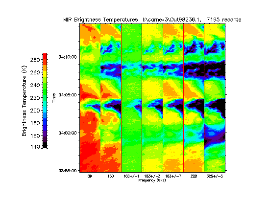
National Aeronautics and Space Administration —
The CAMEX-3 ER-2 Millimeter-wave Imaging Radiometer (MIR) dataset is a browse-only dataset containing plots of brightness temperature measurements collected by the...32 datasets found

Official websites use .gov
A
.gov website belongs to an official government
organization in the United States.
Secure .gov websites use HTTPS
A
lock (
) or https:// means you’ve safely connected to
the .gov website. Share sensitive information only on official,
secure websites.