

81 datasets found
-
Federal
Aviation Safety Reporting System: Penetration of Prohibited Airspace
National Aeronautics and Space Administration —
A sampling of reports involving TFR and ADIZ incidents. -
Federal
Real System Failures
National Aeronautics and Space Administration —
This resource area contains descriptions of actual electronic systems failure scenarios with an emphasis on the diversity of failure modes and effects that can befall... -
Federal
CAMEX-3 DC-8 NAVIGATION (DADS) DATA V1
National Aeronautics and Space Administration —
The CAMEX-3 DC-8 Navigation Data Acquisition and Distribution System (DADS) data files contain information recorded by navigation and data collection systems onboard... -
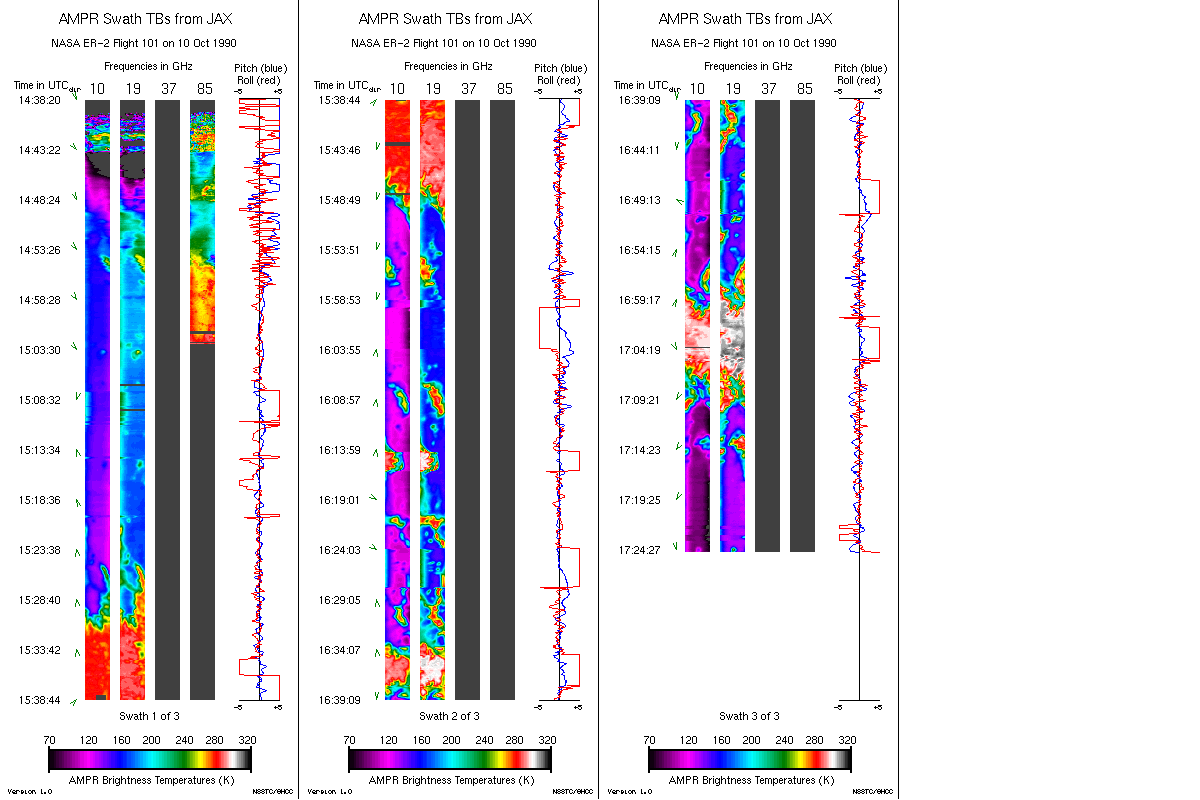
Federal
AMPR JACKSONVILLE BRIGHTNESS TEMPERATURE (TB) V2
National Aeronautics and Space Administration —
The Advanced Microwave Precipitation Radiometer (AMPR) was deployed in Jacksonville, FL for the initial AMPR instrument validation. AMPR data were collected at four... -
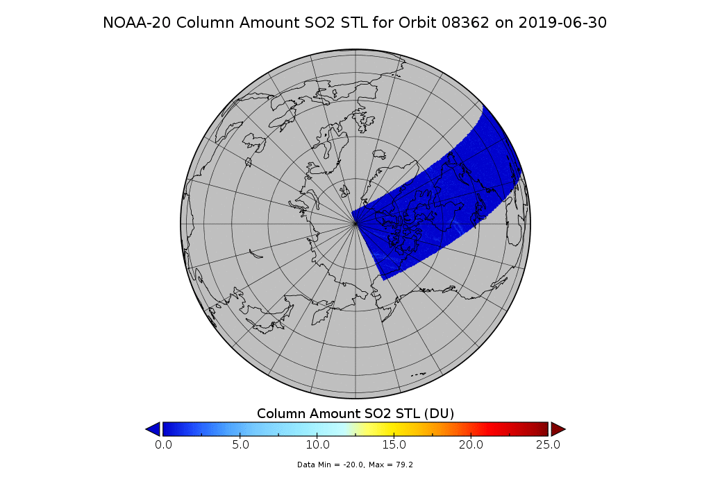
Federal
OMPS-N20 NM PCA SO2 Step 1 Total Column 1-Orbit L2 Swath 17x13km
National Aeronautics and Space Administration —
The OMPS-N20_NM_PCA_SO2 Step1 Total Column 1-Orbit L2 Swath 17x13km collection 1 product contains the retrieved sulfur dioxide (SO2) measured by the Ozone Mapping and... -
Federal
Simulating Degradation Data for Prognostic Algorithm Development
National Aeronautics and Space Administration —
PHM08 Challenge Dataset is now publicly available at the NASA Prognostics Respository +- BMP
- GIF
- BMP
- BMP
FederalGOES-R PLT Cloud Physics LiDAR (CPL) V1
National Aeronautics and Space Administration —
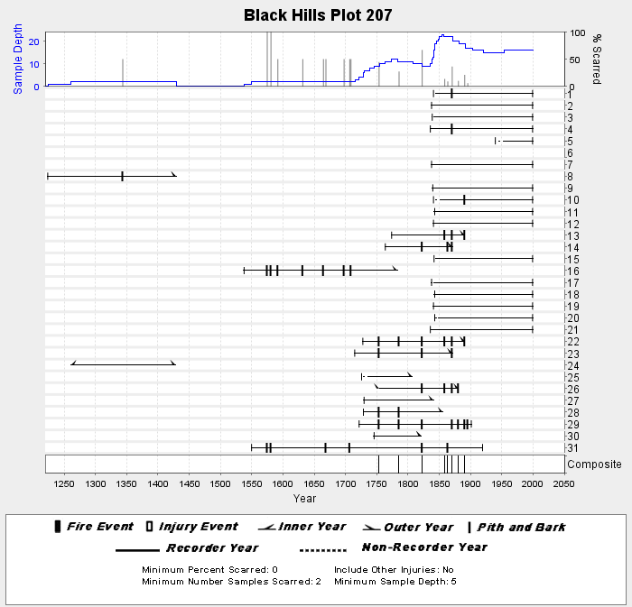
The GOES-R PLT Cloud Physics Lidar (CPL) dataset consists of backscatter coefficient, lidar depolarization ratio, layer top/base height, layer type, particulate...FederalNOAA/WDS Paleoclimatology - Brown fire data from Black Hills Plot 207 - IMPD US207001
National Oceanic and Atmospheric Administration, Department of Commerce —
This archived Paleoclimatology Study is available from the NOAA National Centers for Environmental Information (NCEI), under the World Data Service (WDS) for...FederalImages
National Aeronautics and Space Administration —
Images for the website main pages and all configurations. The upload and access points for the other images are: Website Template RSW images BSCW Images HIRENASD ImagesFederalCloud Profiling Radar System (CPRS): U. Mass, 95/33 gHz radar, graphs
Department of Energy —
No description foundFederalAMPR FIRE III ACE V1
National Aeronautics and Space Administration —
The Advanced Microwave Precipitation Radiometer (AMPR) was deployed during the First ISCCP Regional Experiment-III Arctic Cloud Experiment (FIRE-III/ACE). AMPR data...FederalGPM Ground Validation CXSI Radar Imagery OLYMPEX V1
National Aeronautics and Space Administration —
The GPM Ground Validation CXSI Radar Imagery OLYMPEX dataset contains radar reflectivity and precipitation rate images obtained from Environment and Climate Change...StateHEC DSSVue Plugins
State of California —
Introduction Plugins written to extend HEC-DSSVue # Godin Filter Godin filters are used to remove tidal signals from timeseries of stage, flow and other such...81 datasets found