
-
Federal
Shuttle Radar Topography Mission 1-arc second Global
National Aeronautics and Space Administration —
The Shuttle Radar Topography Mission (SRTM) was flown aboard the space shuttle Endeavour February 11-22, 2000. The National Aeronautics and Space Administration... -
Federal
MEaSUREs Greenland Ice Velocity: Selected Glacier Site Velocity Maps from InSAR V004
National Aeronautics and Space Administration —
This data set, part of the NASA Making Earth System Data Records for Use in Research Environments (MEaSUREs) program, provides velocity estimates determined from... -
Federal
Compendium of Environmental Sustainability Indicator Collections: 2004 Environmental Vulnerability Index (EVI)
National Aeronautics and Space Administration —
The 2004 Environmental Vulnerability Index (EVI) portion of the Compendium of Environmental Sustainability Indicator Collections contains 111 variables for 235... -
Federal
Global Population Density Grid Time Series Estimates
National Aeronautics and Space Administration —
The Global Population Density Grid Time Series Estimates provide a back-cast time series of population density grids based on the year 2000 population grid from... -
Federal
SnowEx23 Airborne Lidar Scans Raw V001
National Aeronautics and Space Administration —
This data set provides raw lidar data from two regions of Alaska, USA collected as part of the NASA SnowEx 2023 field campaign. The study sites include a boreal... -
Federal
Terra MODIS Level-3 Global Binned 11µm Nighttime Sea Surface Temperature (NSST) Data, version R2019.0 NGDA
National Aeronautics and Space Administration —
MODIS (or Moderate-Resolution Imaging Spectroradiometer) is a key instrument aboard the Terra (EOS AM) and Aqua (EOS PM) satellites. Terra's orbit around the Earth is... -
Federal
MEaSUREs Greenland Image Mosaics from Sentinel-1A and -1B V004
National Aeronautics and Space Administration —
This data set, part of the NASA Making Earth System Data Records for Use in Research Environments (MEaSUREs) Program, consists of 6-day and 12-day 50 m resolution... -
Federal
SnowEx23 CRREL Ground Penetrating Radar Raw V001
National Aeronautics and Space Administration —
This data set contains the results of 1 GHz ground-penetrating radar surveys conducted in Alaska, USA as part of the NASA SnowEx 2023 field campaign. The study site... -
Federal
MEaSUREs BedMachine Antarctica V003
National Aeronautics and Space Administration —
This data set, part of the NASA Making Earth System Data Records for Use in Research Environments (MEaSUREs) program, contains a bed topography/bathymetry map of... -
Federal
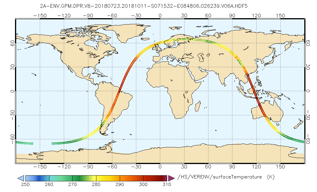
GPM Ground Validation CXSI Radar Imagery OLYMPEX V1
National Aeronautics and Space Administration —
The GPM Ground Validation CXSI Radar Imagery OLYMPEX dataset contains radar reflectivity and precipitation rate images obtained from Environment and Climate Change... -
Federal
IceBridge HiCARS 1 L2 Geolocated Ice Thickness V001
National Aeronautics and Space Administration —
This data set contains ice thickness, surface and bed elevation, and echo strength measurements taken over Antarctica using the Hi-Capability Airborne Radar Sounder... -
Federal
Terra MODIS Level-3 Global Mapped 11µm Nighttime Sea Surface Temperature (NSST) Data, version R2019.0 NGDA
National Aeronautics and Space Administration —
MODIS (or Moderate-Resolution Imaging Spectroradiometer) is a key instrument aboard the Terra (EOS AM) and Aqua (EOS PM) satellites. Terra's orbit around the Earth is... -
Federal
NASA Landsat Data Collection
National Aeronautics and Space Administration —
The NASA Landsat Data Collection (NLDC) is a compilation of Landsat multispectral scanner (MSS) scenes and Landsat thematic mapper (TM) scenes. This compilation of... -
Federal
Aqua MODIS Level-1 Data NGDA
National Aeronautics and Space Administration —
MODIS (or Moderate Resolution Imaging Spectroradiometer) is a key instrument aboard the Terra (EOS AM) and Aqua (EOS PM) satellites. Terra's orbit around the Earth is... -
Federal
Sentinel-3A OLCI Regional Binned Inland Waters (ILW) Data, version 4
National Aeronautics and Space Administration —
The Inland Waters dataset (ILW) provides data for lakes and other water bodies across the contiguous United States (CONUS) and Alaska. ILW significantly reduces the... -
Federal
MEaSUREs Phase-Based Antarctica Ice Velocity Map V001
National Aeronautics and Space Administration —
This data set, as part of the NASA Making Earth System Data Records for Use in Research Environments (MEaSUREs) Program, combines interferometric phases from multiple... -
Federal
GPM Ground Validation Optical Disdrometer (ODM) LPVEx V1
National Aeronautics and Space Administration —
The GPM Ground Validation Optical Disdrometer (ODM) LPVEx dataset consists of precipitation particle size distribution data collected by the Eigenbrodt Optical... -
Federal
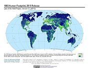
Last of the Wild Project, Version 3 (LWP-3): 1993 Human Footprint, 2018 Release
National Aeronautics and Space Administration —
The 1993 Human Footprint, 2018 Release provides a global map of the cumulative human pressure on the environment in 1993, at a spatial resolution of ~1 km. The human... -
Federal
MEaSUREs Northern Hemisphere State of Cryosphere Daily 25km EASE-Grid 2.0 V001 NGDA
National Aeronautics and Space Administration —
This data set, part of the NASA Making Earth System Data Records for Use in Research Environments (MEaSUREs) program, reports the location of Northern Hemisphere snow... -
Federal
GPM DPR L2A Environment 1.5 hours 5 km V07 (GPM_2ADPRENV) at GES DISC
National Aeronautics and Space Administration —
Version 07 is the current version of the data set. Older versions will no longer be available and have been superseded by Version 07. . This is environmental data...

Official websites use .gov
A
.gov website belongs to an official government
organization in the United States.
Secure .gov websites use HTTPS
A
lock (
) or https:// means you’ve safely connected to
the .gov website. Share sensitive information only on official,
secure websites.