
-
MERRA-2 inst3_3d_aer_Nv: 3d,3-Hourly,Instantaneous,Model-Level,Assimilation,Aerosol Mixing Ratio 0.625 x 0.5 degree V5.12.4 (M2I3NVAER) at GES DISC recent views
M2I3NVAER (or inst3_3d_aer_Nv) is an instantaneous 3-dimensional 3-hourly data collection in Modern-Era Retrospective analysis for Research and Applications version 2 (MERRA-2).... -
CALIPSO Lidar Level 2 Cloud Profile, V4-20 recent views
CAL_LID_L2_05kmCPro-Standard-V4-20 is the Cloud-Aerosol Lidar and Infrared Pathfinder Satellite Observations (CALIPSO) Lidar Level 2 Cloud Profile, Version 4-20 data product.... -
Global Fire Emissions Database, Version 4.1 (GFEDv4) NGDA recent views
This dataset provides global estimates of monthly burned area, monthly emissions and fractional contributions of different fire types, daily or 3-hourly fields to scale the... -
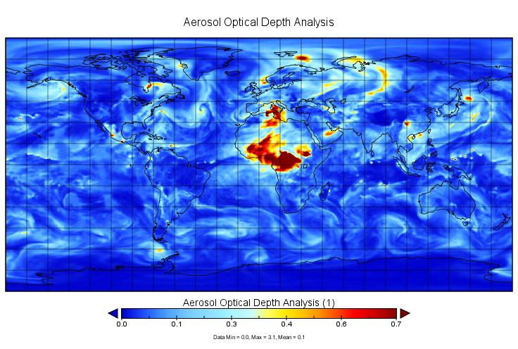
MERRA-2 inst3_2d_gas_Nx: 2d,3-Hourly,Instantaneous,Single-Level,Assimilation,Aerosol Optical Depth Analysis 0.625 x 0.5 degree V5.12.4 (M2I3NXGAS) at GES DISC recent views
M2I3NXGAS (or inst3_3d_gas_Nx) is an instantaneous 2-dimensional 3-hourly data collection in Modern-Era Retrospective analysis for Research and Applications version 2 (MERRA-2).... -
MISR Level 3 Component Global Aerosol Product covering a month V004 recent views
MIL3MAE_4 is the Multi-angle Imaging SpectroRadiometer (MISR) Level 3 Component Global Aerosol Product covering a month version 4. It contains a statistical summary of column... -
MODIS/Terra Aerosol Cloud Water Vapor Ozone Daily L3 Global 1Deg CMG NGDA recent views
The MODIS/Terra Aerosol Cloud Water Vapor Ozone Daily L3 Global 1Deg CMG product (MOD08_D3) contains daily 1 x 1 degree grid average values of atmospheric parameters related to... -
CALIPSO Lidar Level 1B profile data, V4-10 recent views
CAL_LID_L1-Standard-V4-10 is the Cloud-Aerosol Lidar and Infrared Pathfinder Satellite Observation (CALIPSO) Lidar Level 1B profile data, Version 4-10 data product. This data... -
CALIPSO Lidar Level 3 Tropospheric Aerosol Profiles, All Sky Data, Standard V4-20 recent views
CAL_LID_L3_Tropospheric_APro_AllSky-Standard-V4-20 is the Cloud-Aerosol Lidar and Infrared Pathfinder Satellite Observation (CALIPSO) Lidar Level 3 Tropospheric Aerosol... -
CALIPSO Lidar Level 2 5 km Aerosol Layer Data, V4-20 recent views
CAL_LID_L2_05kmALay-Standard-V4-20 is the Cloud-Aerosol Lidar and Infrared Pathfinder Satellite Observation (CALIPSO) Lidar Level 2 5 km Aerosol Layer Data, Version 4-20 data... -
CALIPSO Lidar Level 2 Vertical Feature Mask (VFM), V4-51 recent views
CAL_LID_L2_VFM-Standard-V4-21 is the Cloud-Aerosol Lidar and Infrared Pathfinder Satellite Observations (CALIPSO) Lidar Level 2 Vertical Feature Mask (VFM), Version 4-51 data... -
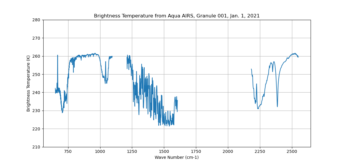
Sounder SIPS: Sun Synchronous 13:30 orbit Climate Hyperspectral InfraRed Product (CHIRP): Calibrated Radiances from EOS-Aqua, V2 (SNDR13CHRP1AQCal) at GES DISC recent views
The Climate Hyperspectral Infrared Radiance Product (CHIRP) is a Level 1 radiance product derived from Atmospheric Infrared Sounder (AIRS) on EOS-AQUA and the Cross-Track... -
DC3 In-Situ NSF/NCAR GV-HIAPER Cloud Data recent views
DC3_Cloud_AircraftInSitu_NSF-GV-HIAPER_Data are in-situ cloud data collected onboard the NSF/NCAR GV-HIAPER aircraft during the Deep Convective Clouds and Chemistry (DC3) field... -
CALIPSO Lidar Level 3 Tropospheric Aerosol Profiles, Cloud Free Data, Standard V4-20 recent views
CAL_LID_L3_Tropospheric_APro_CloudFree-Standard-V4-20 is the Cloud-Aerosol Lidar and Infrared Pathfinder Satellite Observation (CALIPSO) Lidar Level 3 Tropospheric Aerosol... -
NARSTO EPA Supersite (SS) Los Angeles Particulate Matter (PM) 2.5-10 Composition and Mass Data recent views
NARSTO_EPA_SS_LOS_ANGELES_PARTISOL_DATA is the North American Research Strategy for Tropospheric Ozone (NARSTO) Environmental Protection Agency (EPA) Supersite (SS) Los Angeles... -
CERES and MISR Along-Track Footprint Radiances, Fluxes, and Clouds Terra-FM1 NGDA recent views
CERES-MISR-MODIS_SSF-SSFM_Terra-FM1_1 is the Clouds and the Earth's Radiant Energy System (CERES) and Multi-angle Imaging SpectroRadiometer (MISR) Along-Track Footprint... -
MISR Level 3 Component Global Aerosol Regional public Product covering a day V002 recent views
MI3DAER_2 is the Multi-angle Imaging SpectroRadiometer (MISR) Level 3 Component Global Aerosol Regional public Product covering a day version 2. It contains a statistical... -
MODIS/Terra+Aqua Land Aerosol Optical Depth Daily L2G Global 1km SIN Grid V061 NGDA recent views
The MCD19A2 Version 6.1 data product is a Moderate Resolution Imaging Spectroradiometer (MODIS) Terra and Aqua combined Multi-angle Implementation of Atmospheric Correction... -
MISR Level 3 Component Global Aerosol Regional public Product covering a month V002 recent views
MI3MAER_2 is the Multi-angle Imaging SpectroRadiometer (MISR) Level 3 Component Global Aerosol Regional public Product covering a month version 2. It contains a monthly... -
MISR Level 3 Global Joint Aerosol monthly product V002 recent views
MIL3MJTA_2 is the Multi-angle Imaging SpectroRadiometer (MISR) Level 3 Global Joint Aerosol monthly product version 2 data product. It contains global statistical summaries of... -
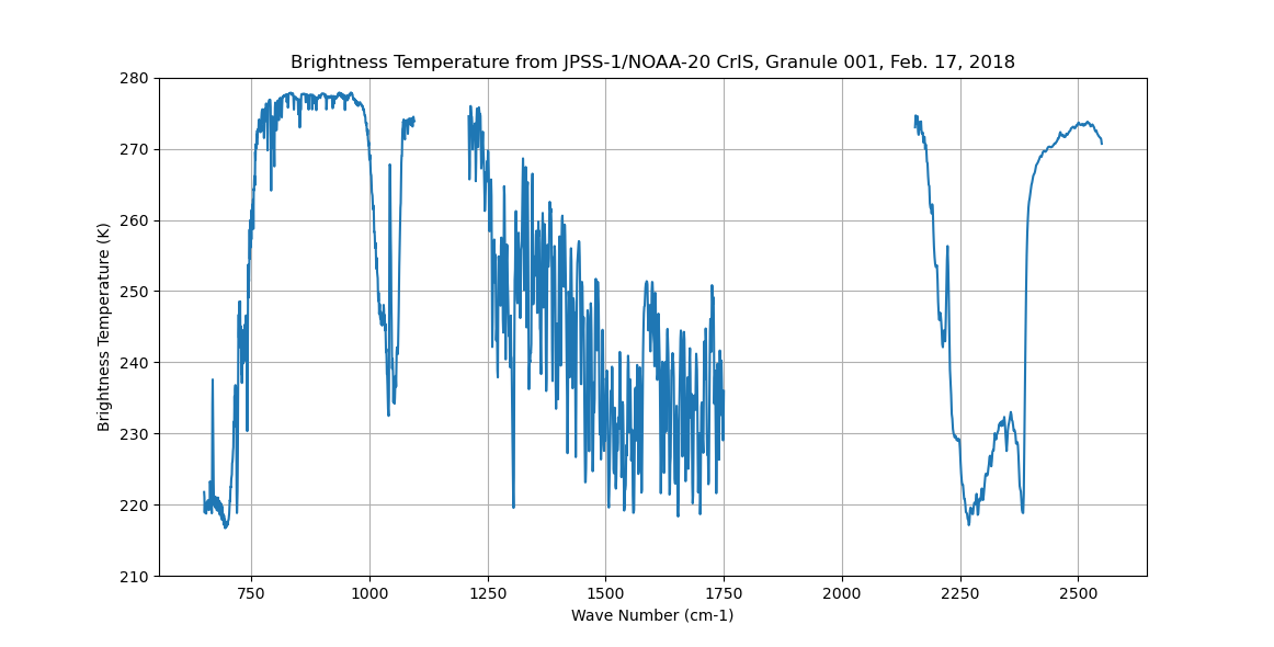
Sounder SIPS: Sun Synchronous 13:30 orbit Climate Hyperspectral InfraRed Product (CHIRP): Calibrated Radiances from JPSS-1/NOAA-20, V2 (SNDR13CHRP1J1Cal) at GES DISC recent views
The Climate Hyperspectral Infrared Radiance Product (CHIRP) is a Level 1 radiance product derived from Atmospheric Infrared Sounder (AIRS) on EOS-AQUA and the Cross-Track...

Official websites use .gov
A
.gov website belongs to an official government
organization in the United States.
Secure .gov websites use HTTPS
A
lock (
) or https:// means you’ve safely connected to
the .gov website. Share sensitive information only on official,
secure websites.