
-
GRIP HURRICANE IMAGING RADIOMETER (HIRAD) V1
The GRIP Hurricane Imaging Radiometer (HIRAD) V1 dataset contains measurements of brightness temperature taken at 4, 5, 6 and 6.6 GHz, as well as MERRA 2 m wind speed data and... -
SWOT Level 2 Radiometer Brightness Temperatures and Troposphere Interim Data Product Version 1.0
The SWOT Level 2 Radiometer Brightness Temperatures and Troposphere Interim Geophysical Data Record (IGDR) Version 1.0 dataset produced by the Surface Water and Ocean Topography... -
SWOT Level 2 Radiometer Brightness Temperatures and Troposphere Operational Data Product, Version 2.0
The SWOT Level 2 Radiometer Brightness Temperatures and Troposphere Operational Geophysical Data Record (OGDR) Version 1.0 dataset produced by the Surface Water and Ocean... -
SWOT Level 2 Radiometer Brightness Temperatures and Troposphere Operational Data Product Version 1.0
The SWOT Level 2 Radiometer Brightness Temperatures and Troposphere Operational Geophysical Data Record (OGDR) Version 1.0 dataset produced by the Surface Water and Ocean... -
Burned and Unburned Field Site Data, Noatak, Seward, and North Slope, AK, 2016-2018
This dataset includes field measurements from unburned and burned 10 m x 10 m and 1 m x 1 m plots in the Noatak, Seward, and North Slope regions of the Alaskan tundra during... -
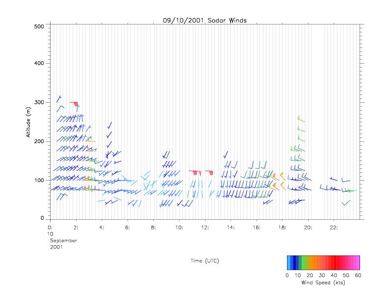
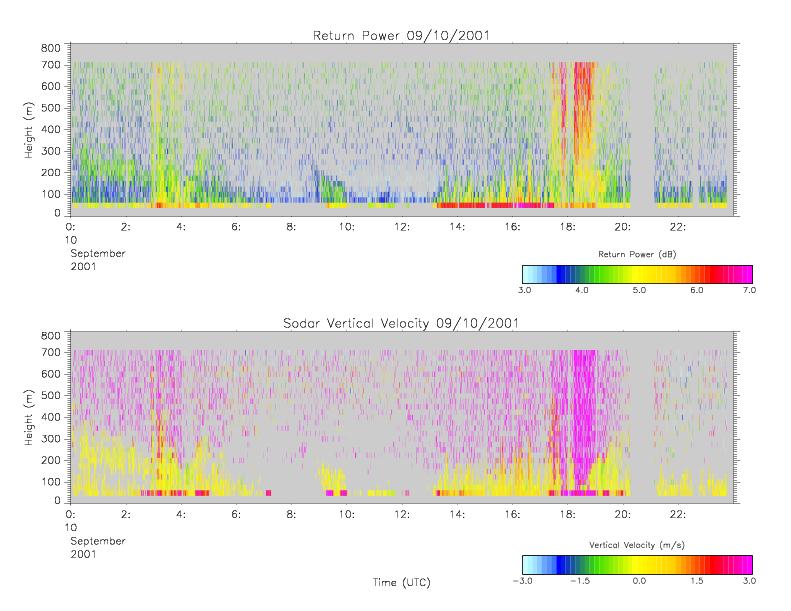
CAMEX-4 MIPS SODAR V1
The University of Alabama in Huntsville (UAH) Mobile Integrated Profiling System (MIPS) is a mobile atmospheric profiling system. It includes a 915 MHz Doppler profiler, lidar... -
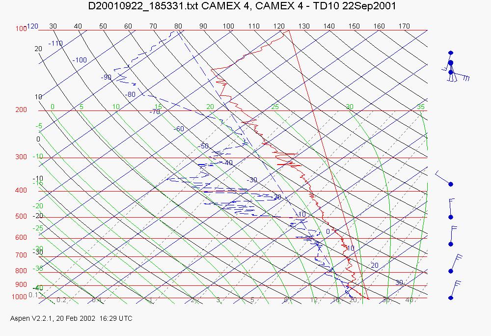
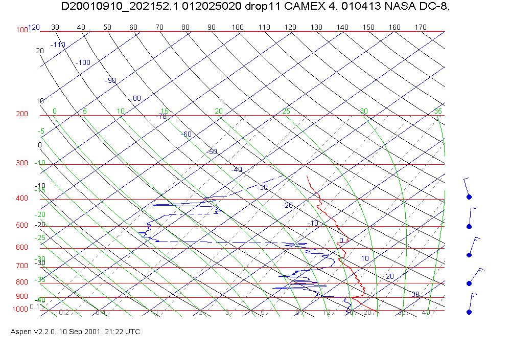
CAMEX-4 ER-2 HIGH ALTITUDE DROPSONDE V1
The CAMEX-4 ER-2 High Altitude Dropsonde dataset was collected by the ER-2 High Altitude Dropsonde System (EHAD), which used dropwinsondes fitted with Global Positioning System... -
ECCO Atmosphere Surface Temperature, Humidity, Wind, and Pressure - Daily Mean llc90 Grid (Version 4 Release 4)
This dataset provides daily-averaged atmosphere surface temperature, humidity, winds, and pressure on the native Lat-Lon-Cap 90 (LLC90) model grid from the ECCO Version 4... -
S-MODE DopplerScatt Level 2 Ocean Winds and Currents Version 1
This dataset contains concurrent airborne DopplerScatt radar retrievals of surface vector winds and ocean currents from the Sub-Mesoscale Ocean Dynamics Experiment (S-MODE)... -
Saildrone field campaign surface and ADCP measurements for the Atlantic Tradewind Ocean-Atmosphere Mesoscale Interaction Campaign (ATOMIC) project
Saildrone is a wind and solar powered unmanned surface vehicle (USV) capable of long distance deployments lasting up to 12 months and providing high quality, near real-time,... -
CARVE: L4 Gridded Footprints from WRF-STILT model, 2012-2016
This data set provides Weather Research and Forecasting (WRF) Stochastic Time-Inverted Lagrangian Transport (STILT) Footprint data products for particle receptors located at... -
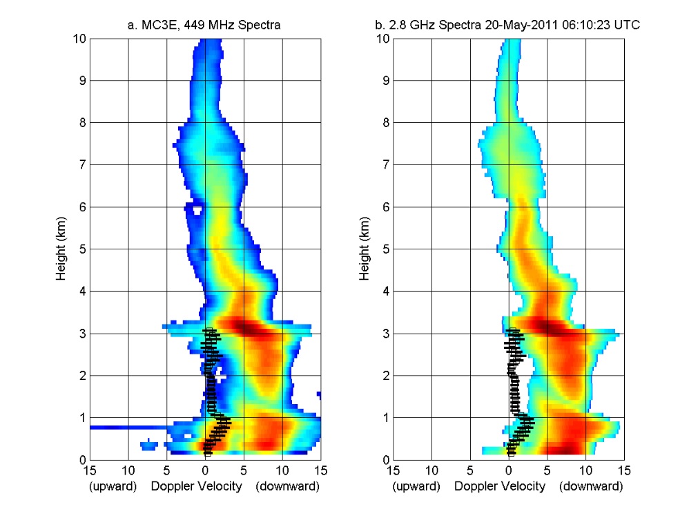
GPM GROUND VALIDATION NOAA UHF 449 PROFILER MC3E V1
The GPM Ground Validation NOAA UHF 449 Profiler MC3E dataset was collected during the NASA supported Midlatitude Continental Convective Clouds Experiment (MC3E). The overarching... -
ECCO Atmosphere Surface Temperature, Humidity, Wind, and Pressure - Monthly Mean llc90 Grid (Version 4 Release 4)
This dataset provides monthly-averaged atmosphere surface temperature, humidity, winds, and pressure on the native Lat-Lon-Cap 90 (LLC90) model grid from the ECCO Version 4... -
SWOT Level 2 Radiometer Brightness Temperatures and Troposphere Interim Data Product, Version 2.0
The SWOT Level 2 Radiometer Brightness Temperatures and Troposphere Interim Geophysical Data Record (IGDR) Version 1.0 dataset produced by the Surface Water and Ocean Topography... -
SPURS-2 Saildrone data for the E. Tropical Pacific field campaign
The SPURS (Salinity Processes in the Upper Ocean Regional Study) project is a NASA-funded oceanographic process study and associated field program that aim to elucidate key... -
Saildrone Arctic field campaign surface and ADCP measurements for NOPP-MISST project
Saildrone is a wind and solar powered unmanned surface vehicle (USV) capable of long distance deployments lasting up to 12 months and providing high quality, near real-time,... -
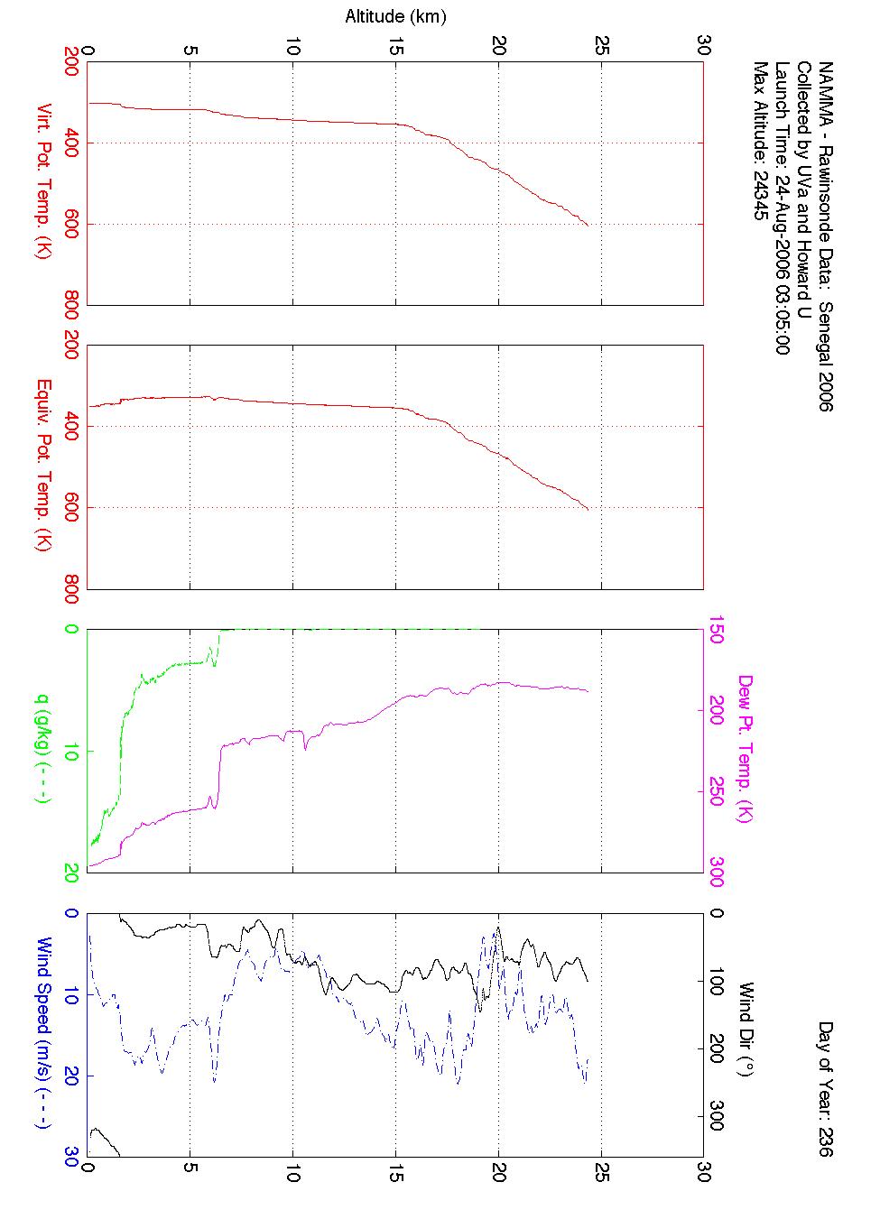
NAMMA SENEGAL RADIOSONDE AND TOWER FLUX DATA V1
The NAMMA Senegal Radiosonde and Tower Flux data includes measurements of humidity, wind speed/direction and velocity. Additionally, the flux data includes photosynthetically... -
ATom: GEOS-5 Derived Meteorological Conditions and Tagged Tracers Along Flight Tracks
This dataset provides modeled meteorological conditions and tagged-CO tracer concentrations along ATom flight paths derived from the Goddard Earth Observing System Version 5... -
CAMEX-4 MIPS SURFACE STATION 2 V1
The University of Alabama in Huntsville (UAH) Mobile Integrated Profiling System (MIPS) is a mobile atmospheric profiling system. It includes a 915 MHz Doppler profiler, lidar... -
CAMEX-4 DC-8 DROPSONDE SYSTEM V1
The CAMEX-4 DC-8 Dropsonde System dataset was collected by the DC-8 Dropsonde System (D8D) uses dropwindsonde and Global Positioning System (GPS) receivers to measure the...

Official websites use .gov
A
.gov website belongs to an official government
organization in the United States.
Secure .gov websites use HTTPS
A
lock (
) or https:// means you’ve safely connected to
the .gov website. Share sensitive information only on official,
secure websites.