

CAMEX-4 MIPS SODAR V1
Access & Use Information
Downloads & Resources
-
Google Scholar search resultsHTML
Search results for publications that cite this dataset by its DOI.
-
Download this datasetHTML
Files may be downloaded directly to your workstation from this link
-
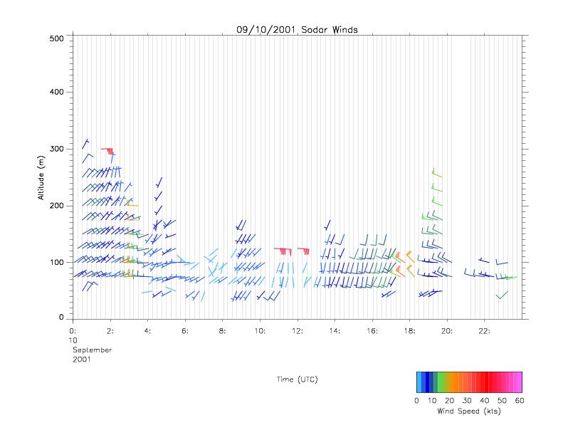
Get a related visualizationJPEG
Sample browse image
-
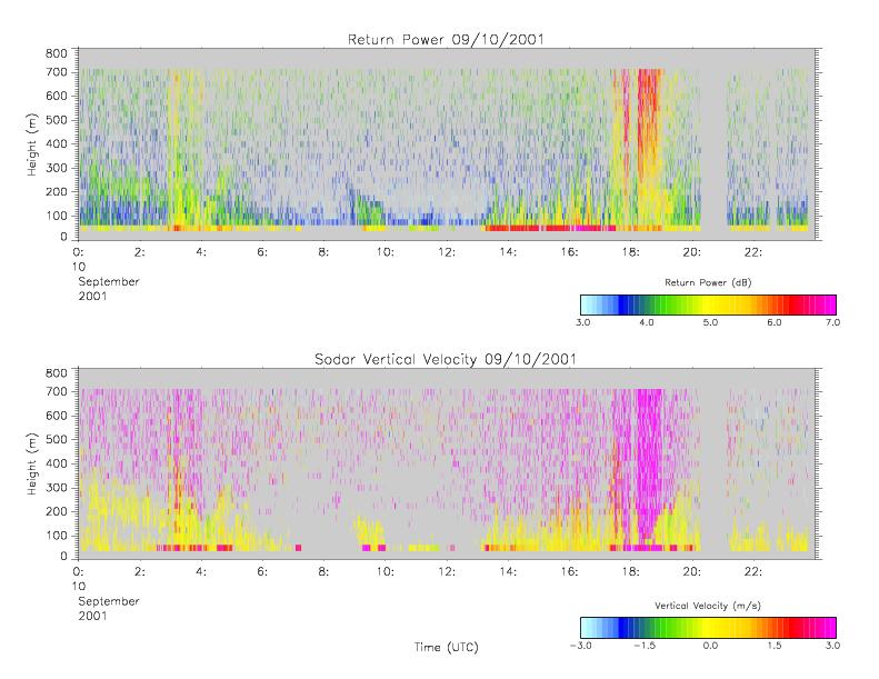
Get a related visualizationJPEG
Sample browse image
-
View documentation related to this datasetHTML
The guide document contains detailed information about the dataset
-
View the primary investigator's documentation...PDF
Components and capabilities of the UAH Mobile Integrated Profiling System (MIPS)
-
View the primary investigator's documentation...DOC
UAH professor to study atmospheric swirls ranging from small waterspouts to...
-
The dataset's project home pageHTML
The home page for the project or program which sponsored the dataset
-
Get a related visualizationHTML
N/A
-
View documentation related to this datasetHTML
Instructions for citing GHRC data
-
Landing PageLanding Page
Dates
| Metadata Created Date | December 1, 2022 |
|---|---|
| Metadata Updated Date | December 6, 2023 |
Metadata Source
- Data.json Data.json Metadata
Harvested from NASA Data.json
Graphic Preview
Additional Metadata
| Resource Type | Dataset |
|---|---|
| Metadata Created Date | December 1, 2022 |
| Metadata Updated Date | December 6, 2023 |
| Publisher | NASA/MSFC/GHRC |
| Maintainer | |
| Identifier | C1979100613-GHRC_DAAC |
| Data First Published | 2002-08-28 |
| Language | en-US |
| Data Last Modified | 2022-05-10 |
| Category | CAMEX-4, geospatial |
| Public Access Level | public |
| Bureau Code | 026:00 |
| Metadata Context | https://project-open-data.cio.gov/v1.1/schema/catalog.jsonld |
| Metadata Catalog ID | https://data.nasa.gov/data.json |
| Schema Version | https://project-open-data.cio.gov/v1.1/schema |
| Catalog Describedby | https://project-open-data.cio.gov/v1.1/schema/catalog.json |
| Citation | Knupp, Kevin and Justin Walters.2002. CAMEX-4 MIPS SODAR indicate subset used. Dataset available online from the NASA Global Hydrometeorology Resource Center DAAC, Huntsville, Alabama, U.S.A. DOI: http://dx.doi.org/10.5067/CAMEX-4/SODAR/DATA201 |
| Graphic Preview Description | N/A |
| Graphic Preview File | https://ghrc.nsstc.nasa.gov/pub/fieldCampaigns/camex4/MIPS_Sodar/browse/ |
| Harvest Object Id | 8d901825-a33c-4b0e-a927-90ebae8d4e35 |
| Harvest Source Id | 58f92550-7a01-4f00-b1b2-8dc953bd598f |
| Harvest Source Title | NASA Data.json |
| Homepage URL | https://doi.org/10.5067/CAMEX-4/SODAR/DATA201 |
| Metadata Type | geospatial |
| Old Spatial | -81.7 24.6 -81.5 24.8 |
| Program Code | 026:001 |
| Source Datajson Identifier | True |
| Source Hash | 2f619eee8fce4d9cb0d4243a36e3f8dd2812e057237eb990086143e5648aa3c6 |
| Source Schema Version | 1.1 |
| Spatial | |
| Temporal | 2001-09-07T00:00:00Z/2001-09-12T23:59:59Z |
Didn't find what you're looking for? Suggest a dataset here.