
-
MLS/Aura Level 2 Chlorine Monoxide (ClO) Mixing Ratio V005 (ML2CLO) at GES DISC
ML2CLO is the EOS Aura Microwave Limb Sounder (MLS) standard product for chlorine monoxide derived from radiances measured primarily by the 640 GHz radiometer. The data version... -
GPM MHS on METOP-C (GPROF) Climate-based Radiometer Precipitation Profiling L2A 1.5 hours 17 km V07 (GPM_2AGPROFMETOPCMHS_CLIM) at GES DISC
Version 07 is the current version of the data set. Older versions are no longer available and have been superseded by Version 07. The "CLIM" products differ from their "regular"... -
VISSR/SMS-2 Level 1 Atmospheric and Oceanographic Image Processing System (AOIPS) Data V001 (VISSRSMS2L1AOIPS) at GES DISC
VISSRSMS2L1AOIPS is the Visible Infrared Spin-Scan Radiometer (VISSR) Level 1 Atmospheric and Oceanographic Image Processing System (AOIPS) data product from the second... -
VISSR/SMS-1 Visible Imagery on 70mm Film V001 (VISSRSMS1IMVIS) at GES DISC
VISSRSMS1IMVIS is the Visible Infrared Spin-Scan Radiometer (VISSR) Visible Imagery on 70mm Film data product from the first Synchronous Meteorological Satellite (SMS-1). This... -
TROPESS CrIS-SNPP L2 Methane for Australian Fires, Standard Product V1 (TRPSDL2CH4CRSAUS) at GES DISC
The TROPESS CrIS-SNPP L2 Methane for Australian Fires, Standard Product contains the vertical distribution of the retrieved atmospheric state of methane (CH4), formal... -
TROPESS CrIS-SNPP L2 Ammonia for West Coast Fires, Standard Product V1 (TRPSDL2NH3CRSWCF) at GES DISC
The TROPESS CrIS-SNPP L2 Ammonia for West Coast Fires, Standard Product contains the vertical distribution of the retrieved atmospheric state of ammonia (NH3), formal... -
THIR/Nimbus-7 Level 1 Calibrated Located Radiation Data at 6.7 and 11.5 microns V001 (THIRN7L1CLDT) at GES DISC
THIRN7L1CLDT is the Nimbus-7 Temperature-Humidity Infrared Radiometer (THIR) Level 1 Calibrated Located Radiation Data (CLDT) at 6.7 and 11.5 microns product and contains... -
OMPS-N21 L2 LP Aerosol Extinction Vertical Profile swath daily 3slit V2 (OMPS_N21_LP_L2_AER_DAILY) at GES DISC
The OMPS-N21 L2 LP Aerosol Extinction Vertical Profile swath daily 3slit (AER) product contains the retrieved aerosol extinction coefficients measured by the Ozone Mapping and... -
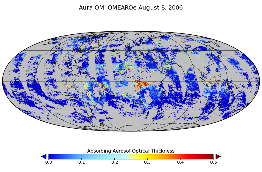
OMI/Aura Multi-wavelength Aerosol Optical Depth and Single Scattering Albedo L3 1 day Best Pixel in 0.25 degree x 0.25 degree V3 (OMAEROe) at GES DISC
The OMI science team produces this Level-3 Aura/OMI Global Aerosol Data Products OMAEROe (0.25deg Lat/Lon grids). The OMAEROe product selects best aerosol value from the Level2G... -
Sounder SIPS: Suomi NPP CrIMSS Level 2 CHART Normal Spectral Resolution: Cloud Cleared Radiances V1
The objective of this limited edition data collection is to examine products generated by the Climate Heritage AIRS Retrieval Technique (CHART) algorithm to analyze Cross-track... -
MLS/Aura Level 2 Carbon Monoxide (CO) Mixing Ratio V005 (ML2CO) at GES DISC
ML2CO is the EOS Aura Microwave Limb Sounder (MLS) standard product for carbon monoxide derived from radiances measured by the 640 GHz radiometer. The data version is 5.0. Data... -
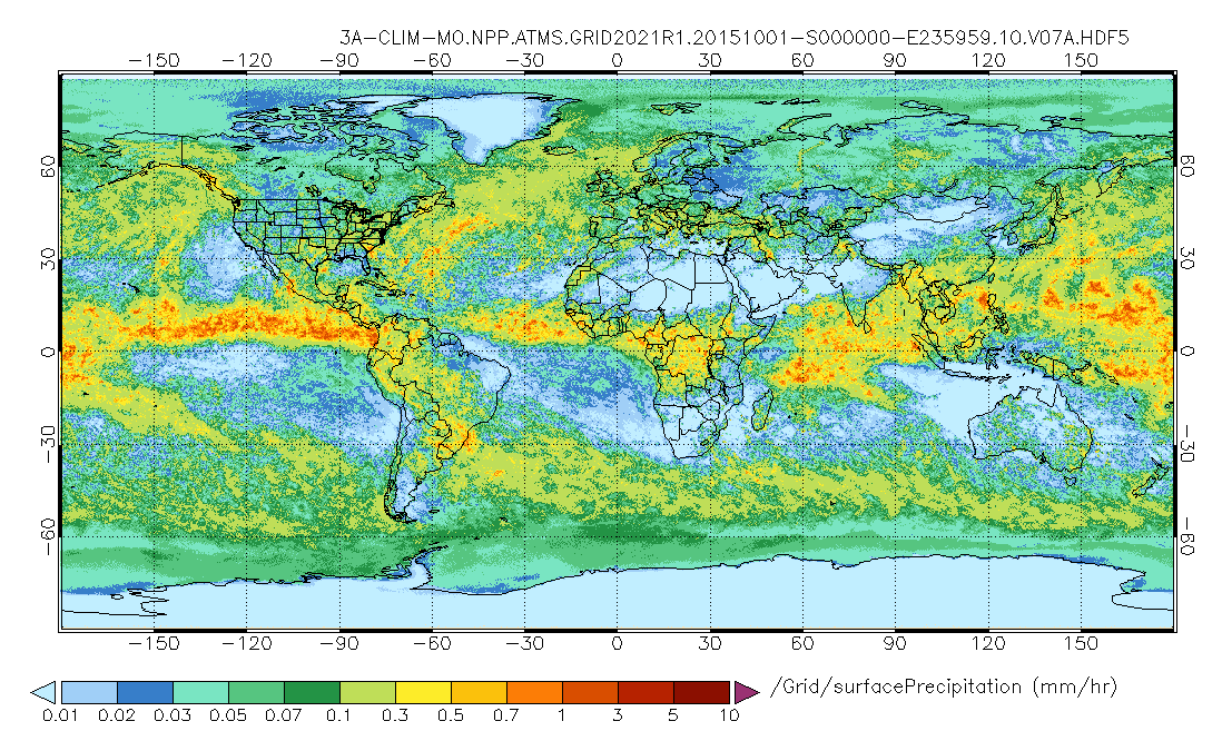
GPM ATMS on SUOMI-NPP (GPROF) Radiometer Precipitation Profiling L3 1 month 0.25 degree x 0.25 degree V07 (GPM_3GPROFNPPATMS_CLIM) at GES DISC
Version 07 is the current version of the data set. Older versions are no longer available and have been superseded by Version 07.The "CLIM" products differ from their "regular"... -
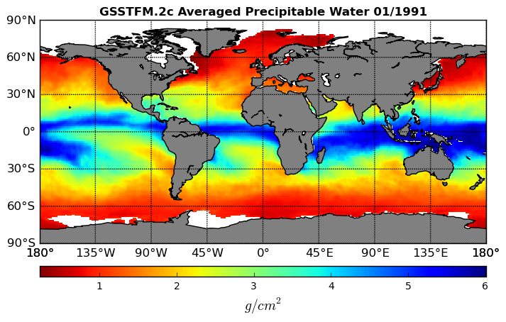
Goddard Satellite-Based Surface Turbulent Fluxes, 0.25 x 0.25 deg, Monthly Grid V3 (GSSTFM) at GES DISC
These data are the Goddard Satellite-based Surface Turbulent Fluxes Version-3 Dataset recently produced through a MEaSUREs funded project led by Dr. Chung-Lin Shie (UMBC/GEST,... -
GEOS-Carb CASA-GFED 3-hourly Ecosystem Exchange Fluxes 0.5 degree x 0.625 degree V3 (GEOS_CASAGFED_3H_NEE) at GES DISC
This product provides 3 hourly average net ecosystem exchange (NEE) and gross ecosystem exchange (GEE)of Carbon derived from the Carnegie-Ames-Stanford-Approach – Global Fire... -
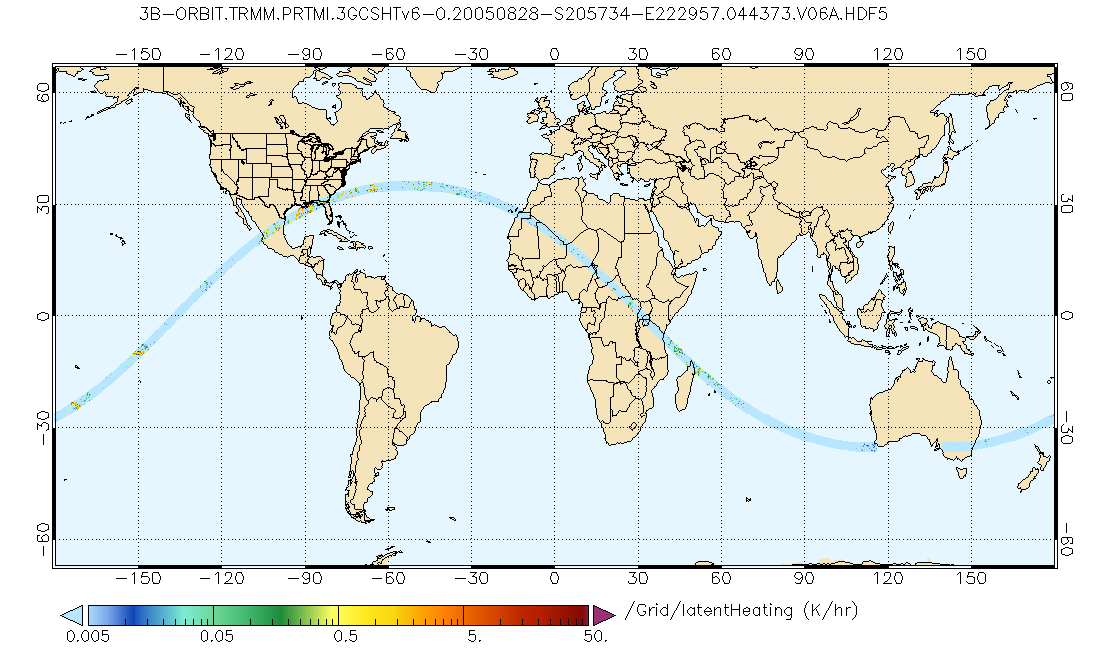
GPM PR and TMI on TRMM Combined Gridded Orbital Convective-Stratiform Latent Heating Profiles L3 1.5 hours 0.25x0.25 degree V07 (GPM_3GCSH_TRMM) at GES DISC
This is the new (GPM-formated) TRMM product. It replaces the old TRMM legacy product TRMM_3G31.Version 07 is the current version of the data set. Older versions will no longer... -
GPM PR and TMI on TRMM Combined Convective-Stratiform Latent Heating Profiles L3 1 month 0.25x0.25 degree V07 (GPM_3HCSH_TRMM) at GES DISC
This is the new (GPM-formated) TRMM product. It replaces the old TRMM legacy TRMM_3H31Version 07 is the current version of the data set. Older versions will no longer be... -
GPM PR on TRMM Precipitation Statistics, at Surface and Fixed Heights 1 day 0.25x0.25 degree V07 (GPM_3PRD) at GES DISC
This a new (GPM-formated) TRMM product. There is no equivalent in the old TRMM suite of products.Version 07 is the current version of the data set. Older versions will no longer... -
Annual Summary of Artificial Light At Night from VIIRS/S-NPP at CONUS County and Census Tract V1 (ALAN_VIIRS_CONUS) at GES DISC
This product provides detailed information about the satellite-based data on artificial light at night (ALAN). The Suomi National Polar-orbiting Partnership (S-NPP) Visible... -
Explorer-7 Thermal Radiation Experiment Selected White Sensor Temperature (Nighttime) Values V001 (EXP7L1TRTWHT) at GES DISC
Explorer-7 Thermal Radiation Experiment Selected White Sensor Temperature (Nighttime) Values product contains the temperatures measured by the white sensor at night. The white... -
GPM SSMIS on F18 (GPROF) Climate-based Radiometer Precipitation Profiling L3 1 month 0.25 degree x 0.25 degree V07 (GPM_3GPROFF18SSMIS_CLIM) at GES DISC
Version 07 is the current version of the data set. Older versions will no longer be available and have been superseded by Version 07. The "CLIM" products differ from their...

Official websites use .gov
A
.gov website belongs to an official government
organization in the United States.
Secure .gov websites use HTTPS
A
lock (
) or https:// means you’ve safely connected to
the .gov website. Share sensitive information only on official,
secure websites.